Scheffau am Tennengebirge

Last updated
Scheffau am Tennengebirge
Scheffau am Tennengebirge - vom Mehlstein gesehen.jpg
Wappen at scheffau.png
Coat of arms
Austria adm location map.svg
Red pog.svg
Scheffau am Tennengebirge
Location within Austria
Coordinates: 47°35′30″N13°12′40″E / 47.59167°N 13.21111°E / 47.59167; 13.21111 Coordinates: 47°35′30″N13°12′40″E / 47.59167°N 13.21111°E / 47.59167; 13.21111
Country Austria
State Salzburg
District Hallein
Government
   Mayor Friedrich Stubreiter (ÖVP)
Area
[1]
  Total69.67 km2 (26.90 sq mi)
Elevation
487 m (1,598 ft)
Population
 (2018-01-01) [2]
  Total1,395
  Density20/km2 (52/sq mi)
Time zone UTC+1 (CET)
  Summer (DST) UTC+2 (CEST)
Postal code
5440
Area code 06244
Vehicle registration HA
Website www.scheffau.salzburg.at

Scheffau am Tennengebirge is a municipality in the Hallein district of Salzburg, Austria.

Geography

The municipality of Scheffau am Tennengebirge lies in the southern Tennengau of the Salzburger Land. The River Lammer flows through its territory. Its subordinate parishes are: Unterscheffau, Oberscheffau, Voregg, Wallingwinkl, Weitenau. Its Katastralgemeinden are Scheffau, Voregg und Weitenau.

The villages lies at the foot of the Tennengebirge mountain range that rises to a height of 2,300 m (7,500 ft) and, to the south, forms the boundary with Pongau. To the north the municipality includes part of the Ostern Group which is up to 1,600 m (5,200 ft) high. The centre of the municipality is in the Lammer valley in Unterscheffau and Oberscheffau.

Related Research Articles

Annaberg-Lungötz Place in Salzburg, Austria

Annaberg-Lungötz is a municipality in the district of Hallein, in the Austrian state of Salzburg.

Ramsau am Dachstein Place in Styria, Austria

Ramsau am Dachstein is a municipality in the district of Liezen, state of Styria, Austria. It is also the name of the elevated plateau between the Dachstein range and the Enns valley on which this municipality is located.

Hohenwarth-Mühlbach am Manhartsberg Place in Lower Austria, Austria

Hohenwarth-Mühlbach am Manhartsberg is a municipality in the district of Hollabrunn in Lower Austria, Austria.

Scheffau am Wilden Kaiser Place in Tyrol, Austria

Scheffau am Wilden Kaiser is a municipality in the district Kufstein in the Austrian region of the Sölllandl. It is located 8.50 km southeast of Kufstein and 13 km northwest of Kitzbühel and has three subdivisions. The main source of income is summer tourism. The village has a public swimming area.

Rußbach am Paß Gschütt Place in Salzburg, Austria

Rußbach am Paß Gschütt is a municipality in the Hallein district in the Austrian state of Salzburg. It is famous for its amazing skiing and summer mountain biking tours and extensive network of hiking trails. It is a must-visit town in Austria and only 40 minutes by car from Salzburg. René Reschreiter is also known here as the person for anything carved out of wood.

Sankt Martin am Tennengebirge Place in Salzburg, Austria

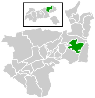
Sankt Martin am Tennengebirge is a municipality in the St. Johann im Pongau district in the Austrian state of Salzburg.

Gilgenberg am Weilhart Place in Upper Austria, Austria

Gilgenberg am Weilhart is a municipality in the district of Braunau am Inn in the Austrian state of Upper Austria.

Höhnhart Place in Upper Austria, Austria

Höhnhart is a municipality in the district of Braunau am Inn in the Austrian state of Upper Austria.

Neukirchen an der Enknach Place in Upper Austria, Austria

Neukirchen an der Enknach is a municipality in the district of Braunau am Inn in the Austrian state of Upper Austria.

Perwang am Grabensee Place in Upper Austria, Austria

Perwang am Grabensee is a municipality in the district of Braunau am Inn in the Austrian state of Upper Austria.

Pfaffstätt Place in Upper Austria, Austria

Pfaffstätt is a municipality in the district of Braunau am Inn in Austrian state of Upper Austria.

Pischelsdorf am Engelbach Place in Upper Austria, Austria

Pischelsdorf am Engelbach is a municipality in the district of Braunau am Inn in the Austrian state of Upper Austria.

Polling im Innkreis Place in Upper Austria, Austria

Polling im Innkreis is a municipality in the district of Braunau am Inn in the Austrian state of Upper Austria.

Sankt Georgen am Fillmannsbach Place in Upper Austria, Austria

St. Georgen am Fillmannsbach, also Sankt Georgen am Fillmannsbach is a municipality in the district of Braunau am Inn in the Austrian state of Upper Austria.

Sankt Johann am Walde Place in Upper Austria, Austria

St. Johann am Walde, also Sankt Johann am Walde is a municipality in the district of Braunau am Inn in the Austrian state of Upper Austria.

Schalchen Place in Upper Austria, Austria

Schalchen is a municipality in the district of Braunau am Inn in the Austrian state of Upper Austria.

Schwand im Innkreis Place in Upper Austria, Austria

Schwand im Innkreis is a municipality in the district of Braunau am Inn in the Austrian state of Upper Austria.

Haag am Hausruck Place in Upper Austria, Austria

Haag am Hausruck is a municipality in the district of Grieskirchen in the Austrian state of Upper Austria. It is home to many great European buildings as well as its own Castle. Haag is located right next to a very large and scenic forest.

Mühlheim am Inn Place in Upper Austria, Austria

Mühlheim am Inn is a municipality in the district of Ried im Innkreis in the Austrian state of Upper Austria.

Obernberg am Inn Place in Upper Austria, Austria

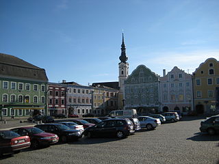
Obernberg am Inn is a municipality in the district of Ried im Innkreis in the Austrian state of Upper Austria.

References

  1. "Dauersiedlungsraum der Gemeinden Politischen Bezirke und Bundesländer - Gebietsstand 1.1.2018". Statistics Austria. Retrieved 10 March 2019.
  2. "Einwohnerzahl 1.1.2018 nach Gemeinden mit Status, Gebietsstand 1.1.2018". Statistics Austria. Retrieved 9 March 2019.
Scheffau am Tennengebirge, seen from the Mehlstein Scheffau am Tennengebirge - vom Mehlstein gesehen II.jpg
Scheffau am Tennengebirge, seen from the Mehlstein