
Rotterdam is the second largest city and municipality in the Netherlands. It is in the province of South Holland, part of the North Sea mouth of the Rhine–Meuse–Scheldt delta, via the "New Meuse" inland shipping channel, dug to connect to the Meuse first, but now to the Rhine instead.
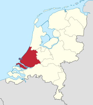
South Holland is a province of the Netherlands with a population of over 3.7 million as of October 2021 and a population density of about 1,373/km2 (3,560/sq mi), making it the country's most populous province and one of the world's most densely populated areas. Situated on the North Sea in the west of the Netherlands, South Holland covers an area of 3,307 km2 (1,277 sq mi), of which 607 km2 (234 sq mi) is water. It borders North Holland to the north, Utrecht and Gelderland to the east, and North Brabant and Zeeland to the south. The provincial capital is the Dutch seat of government The Hague, while its largest city is Rotterdam. The Rhine-Meuse-Scheldt delta drains through South Holland into the North Sea. Europe's busiest seaport, the Port of Rotterdam, is located in South Holland.

Gouda is a city and municipality in the west of the Netherlands, between Rotterdam and Utrecht, in the province of South Holland. Gouda has a population of 75,000 and is famous for its Gouda cheese, stroopwafels, many grachten, smoking pipes, and its 15th-century city hall. Its array of historic churches and other buildings makes it a very popular day trip destination.
Capelle aan den IJssel is a small city and municipality in the western Netherlands, in the province of South Holland. The municipality had a population of 67,319 in 2021, and covers an area of 15.40 km2 (5.95 sq mi), of which 1.26 km2 (0.49 sq mi) is water. It is situated on the eastern edge of Rotterdam, on the Hollandse IJssel river.

Krimpen aan den IJssel is a town and municipality in the western Netherlands, in the province of South Holland. The municipality had a population of 29,410 in 2021, and covers an area of 8.95 km2 (3.46 sq mi) of which 1.26 km2 (0.49 sq mi) is water.

Nieuwerkerk aan den IJssel is a town and former municipality in the western Netherlands, in the province of South Holland. Since 2010 it is part of the new municipality of Zuidplas.

The Hollandse IJssel is a branch of the Rhine delta that flows westward from Nieuwegein on river Lek through IJsselstein, Gouda and Capelle aan den IJssel to Krimpen aan den IJssel, where it ends in the Nieuwe Maas. Another branch called Enge IJssel flows southwest from Nieuwegein. The name IJssel is thought to derive from the Germanic i sala, meaning "dark water". Originally, the Hollandse IJssel forked off from river Lek at Nieuwegein, but the connection was cut off with the Hollandse IJssel nowadays only draining the surrounding pastures.

Adelaide of Holland, Countess of Hainaut, was a Dutch regent. She was a daughter of Floris IV, Count of Holland and Matilda of Brabant. She was also a sister of William II, Count of Holland and King of Germany. She acted as regent for her nephew Count Floris V during his minority.

The 1953 North Sea flood was a major flood caused by a heavy storm surge that struck the Netherlands, north-west Belgium, England and Scotland. Most sea defences facing the surge were overwhelmed, resulting in extensive flooding.

Bouches-de-la-Meuse was a department of the First French Empire in the present-day Netherlands. It was named after the mouth of the river Meuse. It was formed in 1810, when the Kingdom of Holland was annexed by France. Its territory corresponded more or less with the present-day Dutch province of South Holland. Its capital was The Hague.

The Dutch Waterline was a series of water-based defences conceived by Maurice of Nassau in the early 17th century, and realised by his half brother Frederick Henry. Combined with natural bodies of water, the Waterline could be used to transform Holland, the westernmost region of the Netherlands and adjacent to the North Sea, almost into an island. In the 19th century, the Line was extended to include Utrecht.

The Rotterdam Metro is a rapid transit system operated in Rotterdam, Netherlands and surrounding municipalities by RET. The first line, called Noord – Zuidlijn opened in 1968 and ran from Centraal Station to Zuidplein, crossing the river Nieuwe Maas in a tunnel. It was the first metro system to open in the Netherlands. At the time it was also one of the shortest metro lines in the world with a length of only 5.9 km (3.7 mi).

The Roman Catholic Diocese of Rotterdam is a Latin diocese of the Catholic Church in South Holland province of the Netherlands. The diocese is a suffragan in the ecclesiastical province of the Metropolitan Archbishop of Utrecht. Since 2011, the bishop has been Hans van den Hende.

Krimpenerwaard is a municipality, a region and a former water board of the Netherlands. It is a rural area located in the east of the province of South Holland, just south of Gouda and east of the Rotterdam conurbation. It is bordered on the north by the river Hollandse IJssel, on the south by the river Lek and on the east by the stream Vlist.

Rijnmond is the conurbation surrounding the city of Rotterdam in the Netherlands. Another term used in this context is Stadsregio Rotterdam. Located on the Rhine–Meuse–Scheldt delta, the region has a combined population of 1,242,378 as of 2016.

The Zuidplaspolder is a polder in the western Netherlands, located northeast of Rotterdam, Zuid-Holland, neighbouring settlements such as Zuidplas, Zevenhuizen, Waddinxveen, Moerkapelle, Gouda, Moordrecht, and Nieuwerkerk aan den IJssel. It reaches a depth of 6.76 metres below average sea level. This makes it, along with Lammefjord in Denmark, the lowest point of the European Union.
The Government of Rotterdam is the government of the municipality and city of Rotterdam in the Netherlands. Most of the inhabitants live in the city of Rotterdam, but the municipality also covers a number of small villages, and other parts of the local government, such as Rozenburg, cover an even larger area.

Piet Arie de Ruiter was a Dutch politician. He served as a member of the House of Representatives of the Netherlands between 1971 and 1976 for the Labour Party. He also served on the Public Body Rijnmond.
The Stormvloedkering Hollandse IJssel, Hollandse IJsselkering or Algerakering is a storm surge barrier located on the Hollandse IJssel, at the municipal boundary of Capelle aan den IJssel and Krimpen aan den IJssel, east of Rotterdam in The Netherlands. The construction of the works comprised the first project of the Delta Works, undertaken in response to the disastrous effects of the North Sea flood of 1953. Prior to 1954, the spelling Hollandsche was used in the official name.

