
The Lower Mainland is a name commonly applied to the region surrounding and including Vancouver, British Columbia, Canada. As of 2016, 2,759,365 people, lived in the region; sixteen of the province's thirty most populous municipalities are located there. Islands contained within rivers in the region are considered to be part of the Lower Mainland.

Port Alberni is a city located on Vancouver Island in the province of British Columbia, Canada.
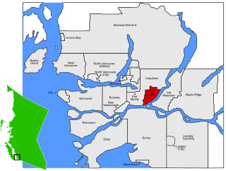
Port Coquitlam is a city in British Columbia, Canada. Located 27 km (17 mi) east of Vancouver, it is on the north bank of the confluence of the Fraser River and the Pitt River. Coquitlam borders it on the north, the Coquitlam River borders it on the west, and the city of Pitt Meadows lies across the Pitt River. Port Coquitlam is almost entirely bisected by Lougheed Highway. Port Coquitlam is often referred to as "PoCo." It is Canada's 88th-largest city by population.
Port Coquitlam is not to be confused with the adjacent and larger Coquitlam.
Parksville is a city on Vancouver Island in British Columbia, Canada. The city lies along Highway 19A, 37 kilometres northwest of Nanaimo, 48 kilometres east of Port Alberni and 7 kilometres southeast of Qualicum Beach. The majority of Parksville's land base lies between Englishman River and French Creek, although a substantial portion of the city lies east of Englishman River, along the western shores of Craig Bay. As of the 2016 Census, Parksville's population was 12,514, representing a 4.5% increase over the 2011 Census.

Port McNeill is a town in the North Island region of Vancouver Island, British Columbia, Canada with a population of 2,623 (2006). Located on Vancouver Island's north-east shore on Queen Charlotte Strait, it was originally a base camp for loggers. Port McNeill became a settlement in 1936. The town was named after Captain William Henry McNeill of the Hudson's Bay Company.

Qualicum Beach is a town located on Vancouver Island British Columbia, Canada. At the 2016 census, it had a population of 8,943. It is situated at the foot of Mount Arrowsmith, along the Strait of Georgia on Vancouver Island's northeastern coast.

Ucluelet is a district municipality on the Ucluelet Peninsula on the west coast of Vancouver Island in British Columbia, Canada. Ucluelet means "people of the safe harbour" in the indigenous Nuu-chah-nulth (Nootka) language.

Port Hardy is a district municipality in British Columbia, Canada located on the northeastern end of Vancouver Island. Port Hardy has a population of 4,132 at last census (2016). It is the gateway to Cape Scott Provincial Park, the North Coast Trail and the BC Marine Trail, located on the northernmost tip of Vancouver Island. The community has access to spectacular wilderness adventures, such as kayaking, caving, world-class scuba diving, nature viewing, surfing, unique saltwater rapids, fishing and camping.

The British Columbia Coast or BC Coast is Canada's western continental coastline on the North Pacific Ocean. The usage is synonymous with the term West Coast of Canada.

The Colony of Vancouver Island, officially known as the Island of Vancouver and its Dependencies, was a Crown colony of British North America from 1849 to 1866, after which it was united with the mainland to form the Colony of British Columbia. The united colony joined Canadian Confederation, thus becoming part of Canada, in 1871. The colony comprised Vancouver Island and the Gulf Islands of the Strait of Georgia.

The Regional District of Mount Waddington (RDMW) is a regional district in British Columbia. It takes in the lower Central Coast region centred on the Queen Charlotte Strait coast of northern Vancouver Island and the adjoining parts of mainland British Columbia. It has a total land area of 20,288.4 km² and a 2016 census population of 11,035 persons, most of which is in towns on Vancouver Island and adjoining islands. The administrative centre is in the town of Port McNeill. Other municipalities include the district municipality of Port Hardy, the village of Port Alice, and the village of Alert Bay.

'West Vancouver Schools, also known as WVS or School District 45 West Vancouver, is a school district in British Columbia. It is immediately north of Vancouver and includes the Municipality of West Vancouver, the community of Lions Bay and Bowen Island.
School District 64 Gulf Islands is a school district in British Columbia. It includes the islands off southern Vancouver Island in the Strait of Georgia. This includes Saltspring Island as well as Galiano, Mayne, Saturna, Pender Islands.

School District 70 Alberni is a school district on the west coast of Vancouver Island in British Columbia. The board office and the majority of the schools are located in Port Alberni but the district extends to the west to include Ucluelet, Tofino, and Bamfield.
School District 72 Campbell River is a school district on Vancouver Island in British Columbia. Centered in Campbell River it includes the more rural communities such as Sayward and the adjacent islands between Vancouver Island and mainland British Columbia.
Port Alice is a village of approximately 805 located off on Neroutsos Inlet, northwest of Port McNeill, on Vancouver Island, originally built by Whalen Pulp and Paper Mills of Vancouver. The community is known for its natural environment, pulp mill, and salt water fishing.

Cortes Island is an island in the Discovery Islands archipelago on the coast of British Columbia, Canada. The island is 25 km (15.5 mi) long, 13 km (8.1 mi) wide, and 130 km2 (50 sq mi) in area. It has a population of 1,035 permanent residents. Cortes Island lies within Electoral Area B of the Strathcona Regional District, which provides water and sewerage systems, fire protection, land use planning, parks, recreation, and emergency response.

