
British Columbia is the westernmost province of Canada. Situated between the Pacific Ocean and the Rocky Mountains, the province has a diverse geography, with rugged landscapes that include rocky coastlines, sandy beaches, forests, lakes, mountains, inland deserts and grassy plains. British Columbia borders the province of Alberta to the east; the territories of Yukon and Northwest Territories to the north; the U.S. states of Washington, Idaho and Montana to the south, and Alaska to the northwest. With an estimated population of over 5.6 million as of 2024, it is Canada's third-most populous province. The capital of British Columbia is Victoria, while the province's largest city is Vancouver. Vancouver and its suburbs together make up the third-largest metropolitan area in Canada, with the 2021 census recording 2.6 million people in Metro Vancouver.

Victoria is the capital city of the Canadian province of British Columbia, on the southern tip of Vancouver Island off Canada's Pacific coast. The city has a population of 91,867, and the Greater Victoria area has a population of 397,237. The city of Victoria is the seventh most densely populated city in Canada with 4,406 inhabitants per square kilometre (11,410/sq mi).

Vancouver Island is an island in the northeastern Pacific Ocean and part of the Canadian province of British Columbia. The island is 456 km (283 mi) in length, 100 km (62 mi) in width at its widest point, and 32,100 km2 (12,400 sq mi) in total area, while 31,285 km2 (12,079 sq mi) are of land. The island is the largest by area and the most populous along the west coasts of the Americas.

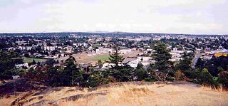
Saanich is a district municipality on Vancouver Island in British Columbia, within the Greater Victoria area. The population was 117,735 at the 2021 census, making it the most populous municipality in the Capital Regional District and Vancouver Island, and the eighth-most populous in the province. The district adopted its name after the Saanich First Nation, meaning "emerging land" or "emerging people". The district acts as a bedroom community immediately to the north of Victoria, British Columbia.
The Township of Esquimalt is a municipality at the southern tip of Vancouver Island, in British Columbia, Canada. It is bordered to the east by the provincial capital, Victoria, to the south by the Strait of Juan de Fuca, to the west by Esquimalt Harbour and Royal Roads, to the northwest by the New Songhees 1A Indian reserve and the town of View Royal, and to the north by a narrow inlet of water called the Gorge, across which is the district municipality of Saanich. It is almost tangential to Esquimalt 1 Indian Reserve near Admirals Road. It is one of the 13 municipalities of Greater Victoria and part of the Capital Regional District.

Greater Victoria is located in British Columbia, Canada, on the southern tip of Vancouver Island. It is usually defined as the thirteen municipalities of the Capital Regional District (CRD) on Vancouver Island as well as some adjacent areas and nearby islands.
Colwood is a city located on Vancouver Island to the southwest of Victoria, capital of British Columbia, Canada. Colwood was incorporated in 1985 and has a population of approximately 19,000 people. Colwood lies within the boundaries of the Greater Victoria area or Capital Regional District, in a region called the Western Communities, or the West Shore. It is one of the 13 component municipalities of Greater Victoria.

Fort Victoria began as a fur trading post of the Hudson's Bay Company and was the headquarters of HBC operations in the Columbia District, a large fur trading area now part of the province of British Columbia, Canada and the U.S. state of Washington. Construction of Fort Victoria in 1843 highlighted the beginning of a permanent British settlement now known as Victoria, the capital city of British Columbia. The fort itself was demolished in November 1864 as the town continued to grow as a commercial centre serving the local area as well as trading with California, Washington Territory, the United Kingdom, and others.

The Victoria Police Department (VicPD) is the municipal police force for the City of Victoria and the Township of Esquimalt, British Columbia, Canada. It is the oldest municipal police department in Canada west of the Great Lakes, the first Canadian law enforcement agency to deploy tasers and VicPD created the first digital forensic unit in the country. They are also one of the few police departments in Canada to use the G36 rifle.
Esquimalt-Port Renfrew was a provincial electoral district in the Canadian province of British Columbia from 1979 to 1986. Its predecessor riding was Esquimalt. It was redistributed into the ridings of Malahat-Juan de Fuca, Esquimalt-Metchosin and Saanich South.

The Colony of Vancouver Island, officially known as the Island of Vancouver and its Dependencies, was a Crown colony of British North America from 1849 to 1866, after which it was united with the mainland to form the Colony of British Columbia. The united colony joined Canadian Confederation, thus becoming part of Canada, in 1871. The colony comprised Vancouver Island and the Gulf Islands of the Strait of Georgia.

École Victor-Brodeur is a French first language K-12 school located in Esquimalt, British Columbia, Canada. It is designed to accommodate 540 students from the Greater Victoria area and to serve as a community centre for the local francophone community. It was named for Royal Canadian Navy officer Victor Brodeur, who was one of the first "group of six" officer cadets accepted into the RCN and also one of the 3% of Quebec born officers to reach the rank of Rear Admiral.
Esquimalt Royal Naval Dockyard was a major British Royal Navy yard on Canada's Pacific coast from 1842 to 1905, subsequently operated by the Canadian government as HMC Dockyard Esquimalt, now part of CFB Esquimalt, to the present day.

Fort Rodd Hill National Historic Site is a 19th-century coastal artillery fort on the Colwood side of Esquimalt Harbour,. The site is adjacent to Fisgard Lighthouse National Historic Site, the first lighthouse on the west coast of Canada. Both the fort and lighthouse are managed and presented to the public by Parks Canada.

John Sebastian Helmcken was a British Columbia physician who played a prominent role in bringing the province into Canadian Confederation. He was also the founding president of the British Columbia Medical Association.

Victoria Harbour is a harbour, seaport, and seaplane airport in the Canadian city of Victoria, British Columbia. It serves as a cruise ship and ferry destination for tourists and visitors to the city and Vancouver Island. It is both a port of entry and an airport of entry for general aviation. Historically it was a shipbuilding and commercial fishing centre. While the Inner Harbour is fully within the City of Victoria, separating the city's downtown on its east side from the Victoria West neighbourhood, the Upper Harbour serves as the boundary between the City of Victoria and the district municipality of Esquimalt. The inner reaches are also bordered by the district of Saanich and the town of View Royal. Victoria is a federal "public harbour" as defined by Transport Canada. Several port facilities in the harbour are overseen and developed by the Greater Victoria Harbour Authority, however the harbour master's position is with Transport Canada.

Randall C. Garrison is a Canadian politician. Elected to the House of Commons in the 2011 federal election, he represents the electoral district of Esquimalt—Saanich—Sooke and is a member of the New Democratic Party. He serves as the party's critic for lesbian, gay, bisexual, and transgender issues, succeeding former MP Bill Siksay, and for National Defence. Since becoming an MP, he has introduced legislation to amend the Canadian Human Rights Act and the Criminal Code, return federal environmental protection to the Goldstream River, and lobbied the government to implement an action plan concerning the endangered Southern resident killer whales. A former criminology and political science instructor at Camosun College, Garrison is openly gay and lives in Esquimalt, British Columbia, with his partner, Teddy Pardede.

Craigflower Elementary School is a public elementary school located in Victoria, British Columbia, Canada. It is the current version of the oldest schoolhouse in Western Canada, and National Historic Site, Craigflower Schoolhouse, and the third school to be called "Craigflower". The third, and current Craigflower School was constructed in the same location in 1963, and has been in constant use for more than half a century.

École Secondaire Esquimalt High School is a high school located in Esquimalt, a township located west of Victoria, British Columbia, Canada. EHS is operated by the Greater Victoria School District. It is the designated secondary school for Shoreline and Rockheights Middle Schools and serves students from Esquimalt, View Royal, and the Victoria neighbourhoods of Vic West and Craigflower. The school is one of three to retain "High School" in its name when the Province of B.C. directed the change to "Secondary School". The school is served by the student-run newspaper Esquimalt Ink.
