Related Research Articles

The Potomac River is a major river in the Mid-Atlantic region of the United States that flows from the Potomac Highlands in West Virginia to the Chesapeake Bay in Maryland. It is 405 miles (652 km) long, with a drainage area of 14,700 square miles (38,000 km2), and is the fourth-largest river along the East Coast of the United States and the 21st-largest in the United States. More than 5 million people live within its watershed.

Wicomico County is located in the southeastern part of the U.S. state of Maryland, on the Delmarva Peninsula. As of the 2020 census, the population was 103,588. The county seat is Salisbury. The county was named for the Wicomico River, which in turn derives its name from the Algonquian language words wicko mekee, meaning "a place where houses are built," apparently referring to a Native American town on the banks. The county is included in the Salisbury, MD-DE Metropolitan Statistical Area.

Salisbury is a city in and the county seat of Wicomico County, Maryland, United States. Salisbury is the largest city in the state's Eastern Shore region, with a population of 33,050 at the 2020 census. Salisbury is the principal city of the Salisbury, Maryland-Delaware Metropolitan Statistical Area. The city is the commercial hub of the Delmarva Peninsula, which was long devoted to agriculture and had a southern culture. It calls itself "The Comfortable Side of Coastal".

The Yadkin River is one of the longest rivers in the US state of North Carolina, flowing 215 miles (346 km). It rises in the northwestern portion of the state near the Blue Ridge Parkway's Thunder Hill Overlook. Several parts of the river are impounded by dams for water, power, and flood control. The river becomes the Pee Dee River at the confluence of the Uwharrie River south of the community of Badin and east of the town of Albemarle. The river then flows into South Carolina near Cheraw, which is at the Fall Line. The entirety of the Yadkin River and the Great Pee Dee River is part of the Yadkin-Pee Dee River Basin.

The Huron River is a 130-mile-long (210 km) river in southeastern Michigan, rising out of the Huron Swamp in Springfield Township in northern Oakland County and flowing into Lake Erie, as it forms the boundary between present-day Wayne and Monroe counties. Thirteen parks, game areas, and recreation areas are associated with the river, which passes through the cities of Dexter, Ann Arbor, Ypsilanti, Belleville, Flat Rock and Rockwood that were developed along its banks.

The Pocomoke River stretches approximately 66 miles (106 km) from southern Delaware through southeastern Maryland in the United States. At its mouth, the river is essentially an arm of Chesapeake Bay, whereas the upper river flows through a series of relatively inaccessible wetlands called the Great Cypress Swamp, largely populated by Loblolly Pine, Red Maple and Bald Cypress. The river is the easternmost river that flows into Chesapeake Bay. "Pocomoke", though traditionally interpreted as "dark water" by local residents, is now agreed by scholars of the Algonquian languages to be derived from the words for "broken ground."
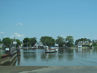
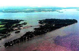
The Wicomico River is a 24.4-mile-long (39.3 km) tributary of the Chesapeake Bay on the eastern shore of Maryland. It drains an area of low marshlands and farming country in the middle Delmarva Peninsula.

The Oswegatchie River is a 137-mile-long (220 km) river in northern New York that flows from the Adirondack Mountains north to the Saint Lawrence River. The Oswegatchie River begins at Partlow Lake in Hamilton County, New York. The river continues through Cranberry Lake which was 'doubled in size' through construction of a dam in the late 1860s. The river continues from the dam to Gouverneur, to near Talcville in St. Lawrence County, where it joins the West Branch. Much of it is within Adirondack State Park. The city of Ogdensburg developed at the mouth of the river at its confluence with the St. Lawrence.
The Wicomico River is a 13.0-mile-long (20.9 km) tributary of the lower tidal portion of the Potomac River located in the U.S. state of Maryland south of Washington, DC. The river empties into the Potomac at Cobb Island and St. Margaret's Island. Its watershed area is 77 square miles (200 km2), with 2% impervious surface in 1994 in Charles, St. Mary's, and southern Prince George's counties. The lower section of the river forms part of the boundary between Charles and St. Mary's counties. The Wicomico River was designated a Scenic River under the Maryland Scenic River Act in 1968. Scenic River Commissions oversee it in Charles and St. Mary's counties..
The Nanticoke River is a tributary of the Chesapeake Bay on the Delmarva Peninsula. It rises in southern Kent County, Delaware, flows through Sussex County, Delaware, and forms the boundary between Dorchester County, Maryland and Wicomico County, Maryland. The tidal river course proceeds southwest into the Tangier Sound, Chesapeake Bay. The river is 64.3 miles (103.5 km) long. A 26-mile ecotourism water trail running along the River was set aside in July 2011 by Delaware state and federal officials, contiguous with a 37-mile water-trail extending through Maryland to the Chesapeake Bay.

The Frankstown Branch Juniata River is a 46.0-mile-long (74.0 km) tributary of the Juniata River in Blair and Huntingdon counties, Pennsylvania, in the United States.

Conewago Creek is an 80.2-mile-long (129.1 km) tributary of the Susquehanna River in Adams and York counties in Pennsylvania in the United States, with its watershed also draining a small portion of Carroll County, Maryland. The source is at an elevation of 1,440 feet (440 m), east of Caledonia State Park, in Franklin Township in Adams County. The mouth is the confluence with the Susquehanna River at York Haven in York County at an elevation of 259 feet (79 m).

Maryland Route 349 is a state highway in the U.S. state of Maryland. Known as Nanticoke Road, the state highway runs 22.32 miles (35.92 km) from a dead end in Nanticoke east to U.S. Route 50 Business in Salisbury. The first segment of MD 349 was constructed by 1910 west of Salisbury. The modern highway reached Quantico by 1919, Bivalve by 1925, and its western terminus by 1933. The only major change to MD 349 since is a realignment near Salisbury in the mid-1950s.
Nassawango Creek is a stream in the U.S. state of Maryland; it is the largest tributary of the Pocomoke River, located on the Delmarva Peninsula. Older variations on the same name include Nassanongo, Naseongo, Nassiongo, and Nassiungo, meaning "[ground] between [the streams]". Early English records have it as Askimenokonson Creek, after a Native settlement near its headwaters.

Boeing Creek is a stream in the U.S. state of Washington, located in the city of Shoreline, just north of Seattle. It is about 1.6 miles (2.6 km) long and empties into Puget Sound. The creek is heavily modified along its course, and in many places has been diverted into culverts. The watershed of Boeing Creek is about 11.2 square miles (29 km2) in size, with two main tributaries aside from the mainstem. The creek takes its name from William Boeing, who built a mansion along the creek in 1913. Despite the river modifications and stormwater pollution, the creek supports a variety of riparian habitats, native animals and fishes.
Beaverdam Creek is a tributary of the Wicomico River on the Eastern Shore of Maryland. Parker Pond and Schumaker Pond were created by damming Beaverdam Creek.
Parker Pond is a pond in Wicomico County, Maryland formed by a widening of Beaverdam Creek.
Beaverdam Creek or Beaver Dam Creek may refer to:
The Beaverdam Formation is an upper Pliocene geologic formation on the Delmarva Peninsula in southern Delaware and eastern Maryland. It is the largest major surficial layer on the Delmarva Peninsula and has a lower stream-deposited unit and an upper estuarine unit. These units may represent a cycle of regression and transgression. The Beaverdam Formation is heterogeneous and ranges from very coarse sand with pebbles to silty clay. It unconformably overlies the Manokin or St. Mary's formations and it is up to 75-100 feet thick.
References
- 1 2 3 4 5 6 7 8 9 10 11 12 13 SURVEY AND MANAGEMENT OF FRESHWATER FISHERIES RESOURCES (PDF). Maryland Department of Natural Resources. 1994. pp. I-4 through I-6. Retrieved 20 January 2015.
- 1 2 "Schumaker Pond – SBY Parks & Recreation Committee" . Retrieved 2020-09-06.
- ↑ "Schumaker Pond". Wicomico River Stewardship Initiative. Retrieved 20 January 2015.
- ↑ "National Dam Inspection Program. Parker Pond Dam (NDI MD00085), Wicomico River Basin, Beaver Dam Creek, Wicomico County, Maryland" (PDF). Defense Technical Information Center. United States Army Corps of Engineers . Retrieved 15 May 2024.