Seafloor depth versus age

Last updated

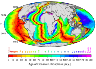
The depth of the seafloor on the flanks of a mid-ocean ridge is determined mainly by the age of the oceanic lithosphere; older seafloor is deeper. During seafloor spreading, lithosphere and mantle cooling, contraction, and isostatic adjustment with age cause seafloor deepening. This relationship has come to be better understood since around 1969 with significant updates in 1974 and 1977. Two main theories have been put forward to explain this observation: one where the mantle including the lithosphere is cooling; the cooling mantle model, and a second where a lithosphere plate cools above a mantle at a constant temperature; the cooling plate model. The cooling mantle model explains the age-depth observations for seafloor younger than 80 million years. The cooling plate model explains the age-depth observations best for seafloor older that 20 million years. In addition, the cooling plate model explains the almost constant depth and heat flow observed in very old seafloor and lithosphere. In practice it is convenient to use the solution for the cooling mantle model for an age-depth relationship younger than 20 million years. Older than this the cooling plate model fits data as well. Beyond 80 million years the plate model fits better than the mantle model.

Contents

Background

The first theories for seafloor spreading in the early and mid twentieth century explained the elevations of the mid-ocean ridges as upwellings above convection currents in Earth's mantle. [1] [2]

The next idea connected seafloor spreading and continental drift in a model of plate tectonics. In 1969, the elevations of ridges was explained as thermal expansion of a lithospheric plate at the spreading center. [3] This 'cooling plate model' was followed in 1974 by noting that elevations of ridges could be modeled by cooling of the whole upper mantle including any plate. [4] This was followed in 1977 by a more refined plate model which explained data that showed that both the ocean depths and ocean crust heat flow approached a constant value for very old seafloor. [5] These observations could not be explained by the earlier 'cooling mantle model' which predicted increasing depth and decreasing heat flow at very old ages.

Seafloor topography: cooling mantle and lithosphere models

The depth of the seafloor (or the height of a location on a mid-ocean ridge above a base-level) is closely correlated with its age (i.e. the age of the lithosphere at the point where depth is measured). Depth is measured to the top of the ocean crust, below any overlying sediment. The age-depth relation can be modeled by the cooling of a lithosphere plate [3] [6] [7] [8] [5] or mantle half-space in areas without significant subduction. [4] The distinction between the two approaches is that the plate model requires the base of the lithosphere to maintain a constant temperature over time and the cooling is of the plate above this lower boundary. The cooling mantle model, which was developed after the plate model, does not require that the lithosphere base is maintained at a constant and limiting temperature. The result of the cooling mantle model is that seafloor depth is predicted to be proportional to the square root of its age. [4]

Cooling mantle model (1974)

In the cooling mantle half-space model developed in 1974, [4] the seabed (top of crust) height is determined by the oceanic lithosphere and mantle temperature, due to thermal expansion. The simple result is that the ridge height or seabed depth is proportional to the square root of its age. [4] In all models, oceanic lithosphere is continuously formed at a constant rate at the mid-ocean ridges. The source of the lithosphere has a half-plane shape (x = 0, z < 0) and a constant temperature T1. Due to its continuous creation, the lithosphere at x > 0 is moving away from the ridge at a constant velocity , which is assumed large compared to other typical scales in the problem. The temperature at the upper boundary of the lithosphere (z = 0) is a constant T0 = 0. Thus at x = 0 the temperature is the Heaviside step function . The system is assumed to be at a quasi-steady state, so that the temperature distribution is constant in time, i.e.

Derivation of the mathematical model for a cooling mantle

By calculating in the frame of reference of the moving lithosphere (velocity ), which has spatial coordinate and the heat equation is:

where is the thermal diffusivity of the mantle lithosphere.

Since T depends on x' and t only through the combination :

Thus:

It is assumed that is large compared to other scales in the problem; therefore the last term in the equation is neglected, giving one-dimensional diffusion equation:

with the initial conditions

The solution for is given by the error function:

.

Due to the large velocity, the temperature dependence on the horizontal direction is negligible, and the height at time t (i.e. of sea floor of age t) can be calculated by integrating the thermal expansion over z:

where is the effective volumetric thermal expansion coefficient, and h0 is the mid-ocean ridge height (compared to some reference).

The assumption that is relatively large is equivalent to the assumption that the thermal diffusivity is small compared to , where L is the ocean width (from mid-ocean ridges to continental shelf) and A is the age of the ocean basin.

The effective thermal expansion coefficient is different from the usual thermal expansion coefficient due to isostasic effect of the change in water column height above the lithosphere as it expands or contracts. Both coefficients are related by:

where is the rock density and is the density of water.

By substituting the parameters by their rough estimates into the solution for the height of the ocean floor :

we have: [4]

where the height is in meters and time is in millions of years. To get the dependence on x, one must substitute t = x/ ~ Ax/L, where L is the distance between the ridge to the continental shelf (roughly half the ocean width), and A is the ocean basin age.

Rather than height of the ocean floor above a base or reference level , the depth of the seabed is of interest. Because (with measured from the ocean surface) we can find that:

; for the eastern Pacific for example, where is the depth at the ridge crest, typically 2500 m. [9]

Cooling plate model (1977)

The depth predicted by the square root of seafloor age found by the 1974 cooling mantle derivation [4] is too deep for seafloor older than 80 million years. [5] Depth is better explained by a cooling lithosphere plate model rather than the cooling mantle half-space. [5] The plate has a constant temperature at its base and spreading edge. Derivation of the cooling plate model also starts with the heat flow equation in one dimension as does the cooling mantle model. The difference is in requiring a thermal boundary at the base of a cooling plate. Analysis of depth versus age and depth versus square root of age data allowed Parsons and Sclater [5] to estimate model parameters (for the North Pacific):

~125 km for lithosphere thickness
at base and young edge of plate

Assuming isostatic equilibrium everywhere beneath the cooling plate yields a revised age-depth relationship for older sea floor that is approximately correct for ages as young as 20 million years:

meters

Thus older seafloor deepens more slowly than younger and in fact can be assumed almost constant at ~6400 m depth. Their plate model also allowed an expression for conductive heat flow, q(t) from the ocean floor, which is approximately constant at beyond 120 million years:

Parsons and Sclater concluded that some style of mantle convection must apply heat to the base of the plate everywhere to prevent cooling down below 125 km and lithosphere contraction (seafloor deepening) at older ages. [5] Morgan and Smith [10] [11] showed that the flattening of the older seafloor depth can be explained by flow in the asthenosphere below the lithosphere.

The age-depth-heat flow relationship continued to be studied with refinements in the physical parameters that define ocean lithospheric plates. [12] [13] [14]

Impacts

The usual method for estimating the age of the seafloor is from marine magnetic anomaly data and applying the Vine-Matthews-Morley hypothesis. Other ways include expensive deep sea drilling and dating of core material. If the depth is known at a location where anomalies are not mapped or are absent, and seabed samples are not available, knowing the seabed depth can yield an age estimate using the age-depth relationships. [4] [5]
Along with this, if the seafloor spreading rate in an ocean basin increases, then the average depth in that ocean basin decreases and therefore its volume decreases (and vice versa). This results in global eustatic sea level rise (fall) because the Earth is not expanding. Two main drivers of sea level variation over geologic time are then changes in the volume of continental ice on the land, and the changes over time in ocean basin average depth (basin volume) depending on its average age. [15]

See also

Related Research Articles

<span class="mw-page-title-main">Plate tectonics</span> Movement of Earths lithosphere

Plate tectonics is the scientific theory that Earth's lithosphere comprises a number of large tectonic plates which have been slowly moving since about 3.4 billion years ago. The model builds on the concept of continental drift, an idea developed during the first decades of the 20th century. Plate tectonics came to be accepted by geoscientists after seafloor spreading was validated in the mid-to-late 1960s.

<span class="mw-page-title-main">Convection</span> Fluid flow that occurs due to heterogeneous fluid properties and body forces.

Convection is single or multiphase fluid flow that occurs spontaneously due to the combined effects of material property heterogeneity and body forces on a fluid, most commonly density and gravity. When the cause of the convection is unspecified, convection due to the effects of thermal expansion and buoyancy can be assumed. Convection may also take place in soft solids or mixtures where particles can flow.

<span class="mw-page-title-main">Seafloor spreading</span> Geological process at mid-ocean ridges

Seafloor spreading, or seafloor spread, is a process that occurs at mid-ocean ridges, where new oceanic crust is formed through volcanic activity and then gradually moves away from the ridge.

<span class="mw-page-title-main">Lithosphere</span> Outermost shell of a terrestrial-type planet or natural satellite

A lithosphere is the rigid, outermost rocky shell of a terrestrial planet or natural satellite. On Earth, it is composed of the crust and the lithospheric mantle, the topmost portion of the upper mantle that behaves elastically on time scales of up to thousands of years or more. The crust and upper mantle are distinguished on the basis of chemistry and mineralogy.

<span class="mw-page-title-main">Asthenosphere</span> Highly viscous, mechanically weak, and ductile region of Earths mantle

The asthenosphere is the mechanically weak and ductile region of the upper mantle of Earth. It lies below the lithosphere, at a depth between ~80 and 200 km below the surface, and extends as deep as 700 km (430 mi). However, the lower boundary of the asthenosphere is not well defined.

<span class="mw-page-title-main">Subduction</span> A geological process at convergent tectonic plate boundaries where one plate moves under the other

Subduction is a geological process in which the oceanic lithosphere and some continental lithosphere is recycled into the Earth's mantle at convergent boundaries. Where the oceanic lithosphere of a tectonic plate converges with the less dense lithosphere of a second plate, the heavier plate dives beneath the second plate and sinks into the mantle. A region where this process occurs is known as a subduction zone, and its surface expression is known as an arc-trench complex. The process of subduction has created most of the Earth's continental crust. Rates of subduction are typically measured in centimeters per year, with rates of convergence as high as 11 cm/year.

<span class="mw-page-title-main">Divergent boundary</span> Linear feature that exists between two tectonic plates that are moving away from each other

In plate tectonics, a divergent boundary or divergent plate boundary is a linear feature that exists between two tectonic plates that are moving away from each other. Divergent boundaries within continents initially produce rifts, which eventually become rift valleys. Most active divergent plate boundaries occur between oceanic plates and exist as mid-oceanic ridges.

<span class="mw-page-title-main">Oceanic crust</span> Uppermost layer of the oceanic portion of a tectonic plate

Oceanic crust is the uppermost layer of the oceanic portion of the tectonic plates. It is composed of the upper oceanic crust, with pillow lavas and a dike complex, and the lower oceanic crust, composed of troctolite, gabbro and ultramafic cumulates. The crust overlies the rigid uppermost layer of the mantle. The crust and the rigid upper mantle layer together constitute oceanic lithosphere.

<span class="mw-page-title-main">Forearc</span> The region between an oceanic trench and the associated volcanic arc

Forearc is a plate tectonic term referring to a region in a subduction zone between an oceanic trench and the associated volcanic arc. Forearc regions are present along convergent margins and eponymously form 'in front of' the volcanic arcs that are characteristic of convergent plate margins. A back-arc region is the companion region behind the volcanic arc.

<span class="mw-page-title-main">Mid-ocean ridge</span> Basaltic underwater mountain system formed by plate tectonic spreading

A mid-ocean ridge (MOR) is a seafloor mountain system formed by plate tectonics. It typically has a depth of about 2,600 meters (8,500 ft) and rises about 2,000 meters (6,600 ft) above the deepest portion of an ocean basin. This feature is where seafloor spreading takes place along a divergent plate boundary. The rate of seafloor spreading determines the morphology of the crest of the mid-ocean ridge and its width in an ocean basin.

<span class="mw-page-title-main">Supercontinent cycle</span> Quasi-periodic aggregation and dispersal of Earths continental crust

The supercontinent cycle is the quasi-periodic aggregation and dispersal of Earth's continental crust. There are varying opinions as to whether the amount of continental crust is increasing, decreasing, or staying about the same, but it is agreed that the Earth's crust is constantly being reconfigured. One complete supercontinent cycle is said to take 300 to 500 million years. Continental collision makes fewer and larger continents while rifting makes more and smaller continents.

<span class="mw-page-title-main">Geothermal gradient</span> Rate of temperature increase with depth in Earths interior

Geothermal gradient is the rate of change in temperature with respect to increasing depth in Earth's interior. As a general rule, the crust temperature rises with depth due to the heat flow from the much hotter mantle; away from tectonic plate boundaries, temperature rises in about 25–30 °C/km (72–87 °F/mi) of depth near the surface in most of the world. However, in some cases the temperature may drop with increasing depth, especially near the surface, a phenomenon known as inverse or negative geothermal gradient. The effects of weather, the Sun, and season only reach a depth of roughly 10–20 m (33–66 ft).

<span class="mw-page-title-main">Passive margin</span> Transition between oceanic and continental lithosphere that is not an active plate margin

A passive margin is the transition between oceanic and continental lithosphere that is not an active plate margin. A passive margin forms by sedimentation above an ancient rift, now marked by transitional lithosphere. Continental rifting forms new ocean basins. Eventually the continental rift forms a mid-ocean ridge and the locus of extension moves away from the continent-ocean boundary. The transition between the continental and oceanic lithosphere that was originally formed by rifting is known as a passive margin.

<span class="mw-page-title-main">Mantle convection</span> Gradual movement of the planets mantle

Mantle convection is the very slow creeping motion of Earth's solid silicate mantle as convection currents carry heat from the interior to the planet's surface.

<span class="mw-page-title-main">Geodynamics</span> Study of dynamics of the Earth

Geodynamics is a subfield of geophysics dealing with dynamics of the Earth. It applies physics, chemistry and mathematics to the understanding of how mantle convection leads to plate tectonics and geologic phenomena such as seafloor spreading, mountain building, volcanoes, earthquakes, faulting. It also attempts to probe the internal activity by measuring magnetic fields, gravity, and seismic waves, as well as the mineralogy of rocks and their isotopic composition. Methods of geodynamics are also applied to exploration of other planets.

<span class="mw-page-title-main">Earth's internal heat budget</span> Accounting of the energy flows at and below the planets crust

Earth's internal heat budget is fundamental to the thermal history of the Earth. The flow of heat from Earth's interior to the surface is estimated at 47±2 terawatts (TW) and comes from two main sources in roughly equal amounts: the radiogenic heat produced by the radioactive decay of isotopes in the mantle and crust, and the primordial heat left over from the formation of Earth.

<span class="mw-page-title-main">Lithosphere–asthenosphere boundary</span> Level representing a mechanical difference between layers in Earth’s inner structure

The lithosphere–asthenosphere boundary represents a mechanical difference between layers in Earth's inner structure. Earth's inner structure can be described both chemically and mechanically. The lithosphere–asthenosphere boundary lies between Earth's cooler, rigid lithosphere and the warmer, ductile asthenosphere. The actual depth of the boundary is still a topic of debate and study, although it is known to vary according to the environment.

Ridge push is a proposed driving force for plate motion in plate tectonics that occurs at mid-ocean ridges as the result of the rigid lithosphere sliding down the hot, raised asthenosphere below mid-ocean ridges. Although it is called ridge push, the term is somewhat misleading; it is actually a body force that acts throughout an ocean plate, not just at the ridge, as a result of gravitational pull. The name comes from earlier models of plate tectonics in which ridge push was primarily ascribed to upwelling magma at mid-ocean ridges pushing or wedging the plates apart.

Intraplate volcanism is volcanism that takes place away from the margins of tectonic plates. Most volcanic activity takes place on plate margins, and there is broad consensus among geologists that this activity is explained well by the theory of plate tectonics. However, the origins of volcanic activity within plates remains controversial.

<span class="mw-page-title-main">Marine geophysics</span>

Marine geophysics is the scientific discipline that employs methods of geophysics to study the world's ocean basins and continental margins, particularly the solid earth beneath the ocean. It shares objectives with marine geology, which uses sedimentological, paleontological, and geochemical methods. Marine geophysical data analyses led to the theories of seafloor spreading and plate tectonics.

References

  1. Dietz, Robert S. (1961). "Continent and Ocean Basin Evolution by Spreading of the Sea Floor". Nature. 190 (4779): 854–857. Bibcode:1961Natur.190..854D. doi:10.1038/190854a0. ISSN   0028-0836. S2CID   4288496.
  2. Hess, H. H. (November 1962). "History of Ocean Basins" (PDF). In A. E. J. Engel; Harold L. James; B. F. Leonard (eds.). Petrologic studies: a volume to honor A. F. Buddington. Boulder, CO: Geological Society of America. pp. 599–620.
  3. 1 2 McKenzie, D. P.; Sclater, J. G. (1969-03-01). "Heat flow in the eastern pacific and sea floor spreading". Bulletin Volcanologique. 33 (1): 101–117. Bibcode:1969BVol...33..101M. doi:10.1007/BF02596711. ISSN   1432-0819. S2CID   129021651.
  4. 1 2 3 4 5 6 7 8 Davis, E.E; Lister, C. R. B. (1974). "Fundamentals of Ridge Crest Topography". Earth and Planetary Science Letters. 21 (4): 405–413. Bibcode:1974E&PSL..21..405D. doi:10.1016/0012-821X(74)90180-0.
  5. 1 2 3 4 5 6 7 Parsons, Barry; Sclater, John G. (1977-02-10). "An analysis of the variation of ocean floor bathymetry and heat flow with age". Journal of Geophysical Research. 82 (5): 803–827. Bibcode:1977JGR....82..803P. doi:10.1029/jb082i005p00803. ISSN   2156-2202.
  6. McKenzie, Dan P. (1967-12-15). "Some remarks on heat flow and gravity anomalies". Journal of Geophysical Research. 72 (24): 6261–6273. Bibcode:1967JGR....72.6261M. doi:10.1029/JZ072i024p06261.
  7. Sclater, J. G.; Francheteau, J. (1970-09-01). "The Implications of Terrestrial Heat Flow Observations on Current Tectonic and Geochemical Models of the Crust and Upper Mantle of the Earth". Geophysical Journal International. 20 (5): 509–542. Bibcode:1970GeoJ...20..509S. doi: 10.1111/j.1365-246X.1970.tb06089.x . ISSN   0956-540X.
  8. Sclater, John G.; Anderson, Roger N.; Bell, M. Lee (1971-11-10). "Elevation of ridges and evolution of the central eastern Pacific". Journal of Geophysical Research. 76 (32): 7888–7915. Bibcode:1971JGR....76.7888S. doi:10.1029/jb076i032p07888. ISSN   2156-2202.
  9. MacDonald, Ken. "GalAPAGoS: Where Ridge Meets Hotspot". NOAA Ocean Explorer. Retrieved 2023-10-10.
  10. Morgan, Jason Phipps; Smith, Walter H. F. (1992). "Flattening of the sea-floor depth-age curve as a response to asthenospheric flow". Nature. 359 (6395): 524–527. Bibcode:1992Natur.359..524M. doi:10.1038/359524a0. ISSN   1476-4687. S2CID   4326297.
  11. Morgan, Jason Phipps; Smith, Walter H. F. (1994). "Correction: Flattening of the sea-floor depth-age curve as a response to asthenospheric flow". Nature. 371 (6492): 83. doi: 10.1038/371083a0 . ISSN   1476-4687. S2CID   4270220.
  12. Stein, Carol A.; Stein, Seth (1992). "A model for the global variation in oceanic depth and heat flow with lithospheric age". Nature. 359 (6391): 123–129. Bibcode:1992Natur.359..123S. doi:10.1038/359123a0. ISSN   1476-4687. S2CID   4272482.
  13. Mckenzie, D; Jackson, J; Priestley, K (2005-05-15). "Thermal structure of oceanic and continental lithosphere". Earth and Planetary Science Letters. 233 (3–4): 337–349. doi:10.1016/j.epsl.2005.02.005.
  14. Grose, Christopher J. (2012-06-01). "Properties of oceanic lithosphere: Revised plate cooling model predictions". Earth and Planetary Science Letters. 333–334: 250–264. Bibcode:2012E&PSL.333..250G. doi:10.1016/j.epsl.2012.03.037. ISSN   0012-821X.
  15. Miller, Kenneth G. (2009), "Sea Level Change, Last 250 Million Years", in Gornitz, Vivien (ed.), Encyclopedia of Paleoclimatology and Ancient Environments, Encyclopedia of Earth Sciences Series, Springer Netherlands, pp. 879–887, doi:10.1007/978-1-4020-4411-3_206, ISBN   978-1-4020-4551-6

Further reading

McKenzie, Dan (2018-05-30). "A Geologist Reflects on a Long Career". Annual Review of Earth and Planetary Sciences. 46 (1): 1–20. Bibcode:2018AREPS..46....1M. doi: 10.1146/annurev-earth-082517-010111 . ISSN   0084-6597.