
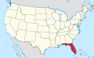
Santa Rosa County is a county located in the northwestern portion of the U.S. state of Florida. As of 2020, the population is 188,000. The county seat is Milton, which lies in the geographic center of the county. Other major communities within Santa Rosa County are Navarre, Pace, and Gulf Breeze. Navarre is the most populated community with a population of approximately 45,000 residents. Santa Rosa County is included in the Pensacola Metropolitan Statistical Area, which also includes Escambia County.

Walton County is located on the Emerald Coast in the northwestern part of the U.S. state of Florida, with its southern border on the Gulf of Mexico. As of the 2020 census, the population was 75,305. Its county seat is DeFuniak Springs. The county is home to the highest natural point in Florida: Britton Hill, at 345 feet (105 m). Walton County is included in the Crestview–Fort Walton Beach–Destin Metropolitan Statistical Area.

Fort Walton Beach, often referred to by the initialism FWB, a city in southern Okaloosa County, Florida. As of the 2020 U.S. census, the population was 20,922, up from 19,507 in 2010. It is the principal city of the Fort Walton Beach−Crestview−Destin Metropolitan Statistical Area.
Shalimar is a town in Okaloosa County, Florida, United States. The population was 717 at the 2010 census. It is part of the Fort Walton Beach–Crestview–Destin Metropolitan Statistical Area.

DeFuniak Springs is a city and the county seat of Walton County, Florida, United States. The population was 6,968 as of the 2020 Census. DeFuniak Springs also serves as a hub for many residents in surrounding communities. In 2019, MSN's Insider Online named the city as the "best small town in Florida".
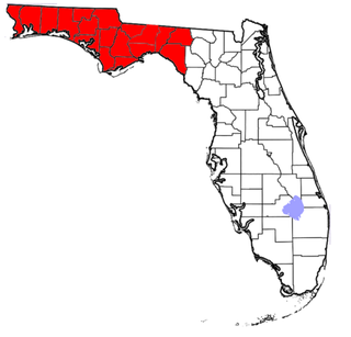
The Florida Panhandle is the northwestern part of the U.S. state of Florida. It is a salient roughly 200 miles long, bordered by Alabama on the north and the west, Georgia on the north, and the Gulf of Mexico to the south. Its eastern boundary is arbitrarily defined. It is defined by its southern culture and rural geography relative to the rest of Florida, as well as closer cultural links to French-influenced Louisiana, Mississippi, and Alabama. Its major communities include Pensacola, Navarre, Destin, Panama City Beach, and Tallahassee.
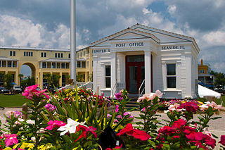
Seaside is an unincorporated master-planned community on the Florida Panhandle in Walton County, between Panama City Beach and Destin. One of the first communities in America designed on the principles of New Urbanism, the town has become the topic of slide lectures in architectural schools and in housing-industry magazines, and is visited by design professionals from all over the United States. On April 18, 2012, the American Institute of Architects's Florida Chapter placed the community on its list of Florida Architecture: 100 Years. 100 Places as the Seaside – New Urbanism Township.
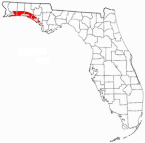
The Emerald Coast is an unofficial name for the coastal area in the US state of Florida on the Gulf of Mexico that stretches about 100 miles (160 km) through five counties, Escambia, Santa Rosa, Okaloosa, Walton, and Bay, which include Pensacola Beach, Navarre Beach, Fort Walton Beach, Destin, and Panama City Beach. Some south Alabama communities on the coast of Baldwin County, such as Gulf Shores, Orange Beach, and Fort Morgan embrace the term as well.

Navarre is a census-designated place and unincorporated community in Santa Rosa County in the northwest Florida Panhandle. It is a major bedroom community for mostly U.S. military personnel, federal civil servants, local population, retirees and defense contractors. Due to Navarre Beach and the 4 miles (6.4 km) of beach front on the Gulf of Mexico thereof, as well as several miles of beaches within the Navarre Beach Marine Park and the Gulf Islands National Seashore, it has a small, but rapidly growing community of nature enthusiasts and tourists. Navarre has grown from being a small town of around 1,500 in 1970 to a town with a population estimated at 43,540 as of 2020, if including both the Navarre and Navarre Beach Census Designated Places.

Florida's 1st congressional district is a congressional district in the U.S. state of Florida, covering the state's western Panhandle. It includes all of Escambia, Okaloosa, and Santa Rosa counties, and portions of Walton county. The district is anchored in Pensacola and also includes the large military bedroom communities and tourist destinations of Navarre and Fort Walton Beach and stretches along the Emerald Coast. The district is currently represented by Republican Matt Gaetz. With a Cook Partisan Voting Index rating of R+19, it is one of the most Republican districts in Florida.

The East Bay River in Florida is a 15-mile-long (24 km) river located in Santa Rosa and Okaloosa counties. It flows from east to west, forming near Hurlburt Field, and empties into the eastern portion of East Bay (Florida) near the towns Holley and Navarre. The river forms part of the southern boundary of Eglin Air Force Base.
Choctawhatchee High School is a high school in Fort Walton Beach, Florida. It is the only school in Okaloosa County to offer the International Baccalaureate Diploma Programme. It also offers the Advanced Placement Program and honors classes, AFJROTC, a dual-enrollment aviation program offered by Embry-Riddle Aeronautical University, and pre-engineering classes. Its newest innovation is the Information Technology Institute housing the Academy of Web Design as well as the Academy of Digital Design. Choctaw has received Florida's highest rating of A+ for many years.
Grayton Beach is a small, historic beach village on the Florida Panhandle Gulf coast halfway between Destin and Panama City in Walton County and adjacent to Grayton Beach State Park. Collectively, the area is known as the “Beaches of South Walton,” with South Walton referring to the southern portion of Walton County below the Choctawhatchee Bay.

Mount Liberty is an unincorporated community in Washington Township, Brown County, in the U.S. state of Indiana.

Santa Rosa Beach is an unincorporated community in Walton County, Florida, United States. It is part of the Fort Walton Beach-Crestview-Destin, Florida Metropolitan Statistical Area.

Northwest Florida State College is a public college in Niceville, Florida. It is part of the Florida College System and is accredited by the Southern Association of Colleges and Schools to award associate and baccalaureate degrees. Northwest Florida State College has multiple campuses but has operated continuously on its Niceville campus since 1963. The college also operates a charter high school, the Collegiate High School at Northwest Florida State College, which opened in 2000.
Seacrest and Seacrest Beach are communities located along County Road 30A in the Florida Panhandle. They are located at the eastern end of scenic highway 30A. Following the development of adjacent Alys Beach, the Seacrest Beach community is split into two geographic areas. The eastern side of Seacrest Beach borders Rosemary Beach and the western side borders WaterSound Beach. Recreational opportunities at the beach community include fishing, kayaking, swimming, golfing, and beachgoing. The nearby coastal dune lake, Camp Creek, offers hiking and bird watching.
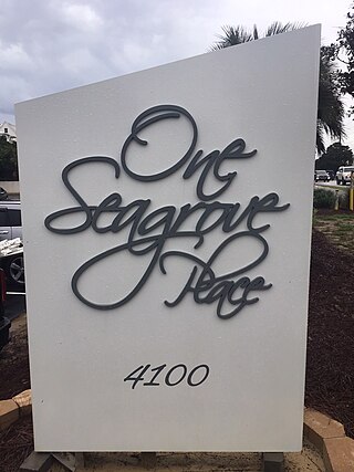
One Seagrove Place is a high-rise condominium located in Seagrove Beach, Florida. It was constructed in 1985 and is the tallest building in South Walton County.


