Search and rescue transponder

Last updated
A standard SART 9 GHz radar transponder, produced by Jotron, on board a Norwegian ferry. The unit is 251 mm high. SART radar transponder.jpg
A standard SART 9 GHz radar transponder, produced by Jotron, on board a Norwegian ferry. The unit is 251 mm high.

A search and rescue transponder (SART) is a self-contained, waterproof transponder intended for emergency use at sea. These devices may be either a radar-SART, or a GPS-based AIS-SART (automatic identification system SART).

Contents

The radar-SART is used to locate a survival craft or distressed vessel by creating a series of dots on a rescuing ship's radar display. A SART will only respond to a 9 GHz X-band (3 cm wavelength) radar. It will not be seen on S-band (10 cm) or other radar. Shipboard Global Maritime Distress Safety System (GMDSS) include one or more search and rescue locating devices. The radar-SART may be triggered by any X-band radar within a range of approximately 8 nautical miles (15 kilometers). Each radar pulse received causes the SART to transmit a response which is swept repetitively across the complete radar frequency band. When interrogated, it first sweeps rapidly (0.4 microsecond) through the band before beginning a relatively slow sweep (7.5 microseconds) through the band back to the starting frequency. This process is repeated for a total of twelve complete cycles. At some point in each sweep, the radar-SART frequency will match that of the interrogating radar and be within the passband of the radar receiver. If the radar-SART is within range, the frequency match during each of the 12 slow sweeps will produce a response on the radar display, thus a line of 12 dots equally spaced by about 0.64 nautical mile (1,185 km) will be shown. When the range to the radar-SART is reduced to about 1 nautical mile (1,852 km), the radar display may show also the 12 responses generated during the fast sweeps. These additional dot responses, which also are equally spaced by 0.64 nautical mile (1.2 km), will be interspersed with the original line of 12 dots. They will appear stronger and larger the closer the interrogating radar gets, slowly becoming arcs at first until the SART is within 1NM, the arcs will become full circles indicating the active SART is in the general area.

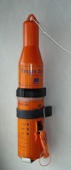
SARTs are typically cylindrical, about the size of a person's forearm, and brightly coloured.

See also

Sources

Related Research Articles

<span class="mw-page-title-main">Emergency position-indicating radiobeacon</span> Distress radio beacon, a tracking transmitter that is triggered during an accident

An emergency position-indicating radiobeacon (EPIRB) is a type of emergency locator beacon for commercial and recreational boats, a portable, battery-powered radio transmitter used in emergencies to locate boaters in distress and in need of immediate rescue. In the event of an emergency, such as a ship sinking or medical emergency onboard, the transmitter is activated and begins transmitting a continuous 406 MHz distress radio signal, which is used by search-and-rescue teams to quickly locate the emergency and render aid. The signal is detected by satellites operated by an international consortium of rescue services, COSPAS-SARSAT, which can detect emergency beacons anywhere on Earth transmitting on the distress frequency of 406 MHz. The satellites calculate the position or utilize the GPS coordinates of the beacon and quickly passes the information to the appropriate local first responder organization, which performs the search and rescue. As Search and Rescue approach the search areas, they use Direction Finding (DF) equipment to locate the beacon using the 121.5 MHz homing signal, or in newer EPIRBs, the AIS location signal. The basic purpose of this system is to help rescuers find survivors within the so-called "golden day" during which the majority of survivors can usually be saved. The feature distinguishing a modern EPIRB, often called GPIRB, from other types of emergency beacon is that it contains a GPS receiver and broadcasts its position, usually accurate within 100 m (330 ft), to facilitate location. Previous emergency beacons without a GPS can only be localized to within 2 km (1.2 mi) by the COSPAS satellites and relied heavily upon the 121.5 MHz homing signal to pin-point the beacons location as they arrived on scene.

A distress signal, also known as a distress call, is an internationally recognized means for obtaining help. Distress signals are communicated by transmitting radio signals, displaying a visually observable item or illumination, or making a sound audible from a distance.

The Global Maritime Distress and Safety System (GMDSS) is a worldwide system for automated emergency signal communication for ships at sea developed by the United Nations' International Maritime Organization (IMO) as part of the SOLAS Convention.

<span class="mw-page-title-main">Distance measuring equipment</span> Radio navigation technology used in aviation

In aviation, distance measuring equipment (DME) is a radio navigation technology that measures the slant range (distance) between an aircraft and a ground station by timing the propagation delay of radio signals in the frequency band between 960 and 1215 megahertz (MHz). Line-of-visibility between the aircraft and ground station is required. An interrogator (airborne) initiates an exchange by transmitting a pulse pair, on an assigned 'channel', to the transponder ground station. The channel assignment specifies the carrier frequency and the spacing between the pulses. After a known delay, the transponder replies by transmitting a pulse pair on a frequency that is offset from the interrogation frequency by 63 MHz and having specified separation.

<span class="mw-page-title-main">Radar beacon</span> Transmitter-receiver associated with a fixed navigational mark

Radar beacon is – according to article 1.103 of the International Telecommunication Union's (ITU) ITU Radio Regulations (RR) – defined as "A transmitter-receiver associated with a fixed navigational mark which, when triggered by a radar, automatically returns a distinctive signal which can appear on the display of the triggering radar, providing range, bearing and identification information." Each station shall be classified by the service in which it operates permanently or temporarily.

<span class="mw-page-title-main">Automatic identification system</span> Automatic tracking system that uses transceivers on ships

The automatic identification system (AIS) is an automatic tracking system that uses transceivers on ships and is used by vessel traffic services (VTS). When satellites are used to receive AIS signatures, the term Satellite-AIS (S-AIS) is used. AIS information supplements marine radar, which continues to be the primary method of collision avoidance for water transport. Although technically and operationally distinct, the ADS-B system is analogous to AIS and performs a similar function for aircraft.

The air traffic control radar beacon system (ATCRBS) is a system used in air traffic control (ATC) to enhance surveillance radar monitoring and separation of air traffic. It consists of a rotating ground antenna and transponders in aircraft. The ground antenna sweeps a narrow vertical beam of microwaves around the airspace. When the beam strikes an aircraft, the transponder transmits a return signal back giving information such as altitude and the Squawk Code, a four digit code assigned to each aircraft that enters a region. Information about this aircraft is then entered into the system and subsequently added to the controller's screen to display this information when queried. This information can include flight number designation and altitude of the aircraft. ATCRBS assists air traffic control (ATC) surveillance radars by acquiring information about the aircraft being monitored, and providing this information to the radar controllers. The controllers can use the information to identify radar returns from aircraft and to distinguish those returns from ground clutter.

<span class="mw-page-title-main">Airborne collision avoidance system</span> Avionics system to avoid aircraft collision

An airborne collision avoidance system operates independently of ground-based equipment and air traffic control in warning pilots of the presence of other aircraft that may present a threat of collision. If the risk of collision is imminent, the system recommends a maneuver that will reduce the risk of collision. ACAS standards and recommended practices are mainly defined in annex 10, volume IV, of the Convention on International Civil Aviation. Much of the technology being applied to both military and general aviation today has been undergoing development by NASA and other partners since the 1980s.

<span class="mw-page-title-main">Transponder landing system</span> All-weather, precision landing system

A transponder landing system (TLS) is an all-weather, precision landing system that uses existing airborne transponder and instrument landing system (ILS) equipment to create a precision approach at a location where an ILS would normally not be available.

<span class="mw-page-title-main">Airport surveillance radar</span> Radar system

An airport surveillance radar (ASR) is a radar system used at airports to detect and display the presence and position of aircraft in the terminal area, the airspace around airports. It is the main air traffic control system for the airspace around airports. At large airports it typically controls traffic within a radius of 60 miles (96 km) of the airport below an elevation of 25,000 feet. The sophisticated systems at large airports consist of two different radar systems, the primary and secondary surveillance radar. The primary radar typically consists of a large rotating parabolic antenna dish that sweeps a vertical fan-shaped beam of microwaves around the airspace surrounding the airport. It detects the position and range of aircraft by microwaves reflected back to the antenna from the aircraft's surface. The secondary surveillance radar consists of a second rotating antenna, often mounted on the primary antenna, which interrogates the transponders of aircraft, which transmits a radio signal back containing the aircraft's identification, barometric altitude, and an emergency status code, which is displayed on the radar screen next to the return from the primary radar.

<span class="mw-page-title-main">Rebecca/Eureka transponding radar</span> World War II airborne radio transponder system

The Rebecca/Eureka transponding radar was a short-range radio navigation system used for the dropping of airborne forces and their supplies. It consisted of two parts, the Rebecca airborne transceiver and antenna system, and the Eureka ground-based transponder. Rebecca calculated the range to the Eureka based on the timing of the return signals, and its relative position using a highly directional antenna. The 'Rebecca' name comes from the phrase "Recognition of beacons". The 'Eureka' name comes from the Greek word meaning "I have found it!".

A radar system uses a radio-frequency electromagnetic signal reflected from a target to determine information about that target. In any radar system, the signal transmitted and received will exhibit many of the characteristics described below.

<span class="mw-page-title-main">RCA AN/FPS-16 Instrumentation Radar</span> Ground radar

The AN/FPS-16 is a highly accurate ground-based monopulse single object tracking radar (SOTR), used extensively by the NASA crewed space program, the U.S. Air Force and the U.S. Army. The accuracy of Radar Set AN/FPS-16 is such that the position data obtained from point-source targets has azimuth and elevation angular errors of less than 0.1 milliradian and range errors of less than 5 yards (5 m) with a signal-to-noise ratio of 20 decibels or greater.

An international distress frequency is a radio frequency that is designated for emergency communication by international agreement.

<span class="mw-page-title-main">Radio</span> Technology of using radio waves to carry information

Radio is the technology of signaling and communicating using radio waves. Radio waves are electromagnetic waves of frequency between 3 hertz (Hz) and 3,000 gigahertz (GHz). They are generated by an electronic device called a transmitter connected to an antenna which radiates the waves, and received by another antenna connected to a radio receiver. Radio is widely used in modern technology, in radio communication, radar, radio navigation, remote control, remote sensing, and other applications.

<span class="mw-page-title-main">AIS-SART</span> Radio transmitter which sends a location signal

The AIS-SART is a self-contained radio device used to locate a survival craft or distressed vessel by sending updated position reports using a standard Automatic Identification System (AIS) class-A position report. The position and time synchronization of the AIS-SART are derived from a built in GNSS receiver . Shipboard Global Maritime Distress Safety System (GMDSS) installations include one or more search and rescue locating devices. These devices may be either an AIS-SART, or a radar-SART.

<span class="mw-page-title-main">Survival radio</span> Small radios carried to facilitate rescue in an emergency

Survival radios are carried by pilots and search and rescue teams to facilitate rescue in an emergency. They are generally designed to transmit on international distress frequencies. Maritime systems have been standardized under the Global Maritime Distress Safety System. Civil and military organisation's utilized different frequencies to communicate and no infringement on either sector would take place. For emergencies involving civilian aircraft, the radio frequency used is VHF 121.5 MHz and for military aircraft incidents, the frequency used is UHF 243 MHz.

<span class="mw-page-title-main">IFF Mark III</span> Aircraft identification friend or foe system

IFF Mark III, also known as ARI.5025 in the UK or SCR.595 in the US, was the Allied Forces standard identification friend or foe (IFF) system from 1943 until well after the end of World War II. It was widely used by aircraft, ships, and submarines, as well as in various adaptations for secondary purposes like search and rescue. 500 units were also supplied to the Soviet Union during the war.

IFF Mark X was the NATO standard military identification friend or foe transponder system from the early 1950s until it was slowly replaced by the IFF Mark XII in the 1970s. It was also adopted by ICAO, with some modifications, as the civilian air traffic control (ATC) secondary radar (SSR) transponder. The X in the name does not mean "tenth", but "eXperimental". Later IFF models acted as if it was the tenth in the series and used subsequent numbers.

An emergency locator beacon is a radio beacon, a portable battery powered radio transmitter, used to locate airplanes, vessels, and persons in distress and in need of immediate rescue. Various types of emergency locator beacons are carried by aircraft, ships, vehicles, hikers and cross-country skiers. In case of an emergency, such as the aircraft crashing, the ship sinking, or a hiker becoming lost, the transmitter is deployed and begins to transmit a continuous radio signal, which is used by search and rescue teams to quickly find the emergency and render aid. The purpose of all emergency locator beacons is to help rescuers find survivors within the so-called "golden day", the first 24 hours following a traumatic event, during which the majority of survivors can usually be saved.