Searles Valley

Last updated

Coordinates: 35°36′N117°18′W / 35.6°N 117.3°W / 35.6; -117.3 [1]

Geographic coordinate system Coordinate system

A geographic coordinate system is a coordinate system that enables every location on Earth to be specified by a set of numbers, letters or symbols. The coordinates are often chosen such that one of the numbers represents a vertical position and two or three of the numbers represent a horizontal position; alternatively, a geographic position may be expressed in a combined three-dimensional Cartesian vector. A common choice of coordinates is latitude, longitude and elevation. To specify a location on a plane requires a map projection.

Contents

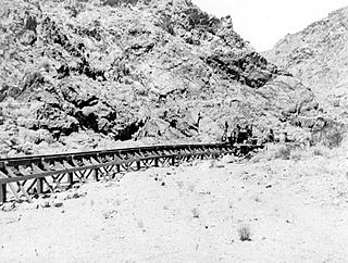
Searles Valley is a valley in the northern Mojave Desert of California, with the northern half in Inyo County and the southern half in San Bernardino County, California, United States.

Mojave Desert desert in southwestern United States

The Mojave Desert is an arid rain-shadow desert and the driest desert in North America. It is in the southwestern United States, primarily within southeastern California and southern Nevada, and it occupies 47,877 sq mi (124,000 km2). Very small areas also extend into Utah and Arizona. Its boundaries are generally noted by the presence of Joshua trees, which are native only to the Mojave Desert and are considered an indicator species, and it is believed to support an additional 1,750 to 2,000 species of plants. The central part of the desert is sparsely populated, while its peripheries support large communities such as Las Vegas, Barstow, Lancaster, Palmdale, Victorville, and St. George.

California State of the United States of America

California is a state in the Pacific Region of the United States. With 39.6 million residents, California is the most populous U.S. state and the third-largest by area. The state capital is Sacramento. The Greater Los Angeles Area and the San Francisco Bay Area are the nation's second- and fifth-most populous urban regions, with 18.7 million and 8.8 million residents respectively. Los Angeles is California's most populous city, and the country's second-most populous, after New York City. California also has the nation's most populous county, Los Angeles County, and its largest county by area, San Bernardino County. The City and County of San Francisco is both the country's second-most densely populated major city after New York City and the fifth-most densely populated county, behind only four of the five New York City boroughs.

Inyo County, California County in California, United States

Inyo County is a county in the U.S. state of California. As of the 2010 census, the population was 18,546. The county seat is Independence.

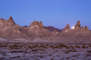
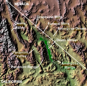
Searles Valley is located between the Argus Range to the west and the Slate Range to the east. Death Valley is to the northeast. The valley contains the landform features of Searles Lake and the Trona Pinnacles.

Argus Range mountain range in Inyo County, California

The Argus Range is a mountain range located in Inyo County, California, southeast of the town of Darwin. The range forms the western boundary of Panamint Valley, and the northwestern boundary of Searles Valley. The Coso Range is located to the west, and the Panamint Range to the east.

Slate Range (California)

The Slate Range is located in the Mojave Desert in San Bernardino County, California, southwest of Death Valley and east of Trona.

Death Valley desert valley located in Eastern California

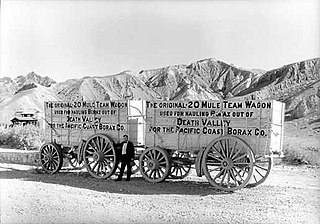
Death Valley is a desert valley located in Eastern California, in the northern Mojave Desert bordering the Great Basin Desert. It is one of the hottest places in the world at the height of summertime along with deserts in the Middle East.

Settlements

The Searles Valley Minerals company town of Trona is the primary settlement. Other towns in the Searles Valley include: Westend, Argus, Pioneer Point, Homewood Canyon, and Searles Valley. Sometimes Argus, Westend, Pioneer Point, and Trona are collectively referred to as Trona.

Searles Valley Minerals U.S. mining and chemical company

Searles Valley Minerals Inc. is a raw materials mining and production company based in Overland Park, Kansas. It is owned by the Indian company Nirma. It has major operations in the Searles Valley and in Trona, California where it is the town's largest employer. The company produces borax, boric acid, soda ash, salt cake and salt. It also owns the Trona Railway.

Company town place where practically all stores and housing are owned by the one company that is also the main employer

A company town is a place where practically all stores and housing are owned by the one company that is also the main employer. Company towns are often planned with a suite of amenities such as stores, churches, schools, markets and recreation facilities. They are usually bigger than a model village.

Trona, San Bernardino County, California Unincorporated community in California, United States

Trona is an unincorporated community in San Bernardino County, California. In 2015 it had a population of approximately 1,900. Trona is at the western edge of Searles Lake, a dry lake bed in Searles Valley, southwest of Death Valley. The town takes its name from the mineral trona, abundant in the lakebed. It is about 170 miles (274 km) northeast of Los Angeles, on State Route 178. The ZIP code is 93562.

See also

Related Research Articles

Geography of California

California is a U.S. state on the western coast of North America. Covering an area of 163,696 sq mi (423,970 km2), California is geographically diverse. The Sierra Nevada, the fertile farmlands of the Central Valley, and the arid Mojave Desert of the south are some of the major geographic features of this U.S. state. It is home to some of the world's most exceptional trees: the tallest, most massive, and oldest. It is also home to both the highest and lowest points in the 48 contiguous states. The state is generally divided into Northern and Southern California, although the boundary between the two is not well defined. San Francisco is decidedly a Northern California city and Los Angeles likewise a Southern California one, but areas in between do not often share their confidence in geographic identity. The US Geological Survey defines the geographic center of the state at a point near North Fork, California.

Area codes 760 and 442 area codes for Mono County, California

Area code 760 is a California telephone area code that was split from area code 619 on March 22, 1997. Area code 442 is an overlay of 760 that became effective on November 21, 2009. It encompasses much of the southeastern and southernmost portions of California. The area includes Imperial, Inyo, and Mono counties, as well as portions of San Diego, Riverside, San Bernardino, Los Angeles and Kern counties.

Christian Brevoort Zabriskie American businessman

Christian Brevoort Zabriskie was an American businessman and vice president of Pacific Coast Borax Company. Zabriskie Point on the northeasternmost flank of the Black Mountains east of Death Valley, located in Death Valley National Park is named after him.

Trona Pinnacles

The Trona Pinnacles are an unusual geological feature in the California Desert National Conservation Area. The unusual landscape consists of more than 500 tufa spires, some as high as 140 feet (43 m), rising from the bed of the Searles Lake (dry) basin. The pinnacles vary in size and shape from short and squat to tall and thin, and are composed primarily of calcium carbonate (tufa). They now sit isolated and slowly crumbling away near the south end of the valley, surrounded by many square miles of flat, dried mud and with stark mountain ranges at either side.

Searles Lake San Bernardino Co., California

Searles Lake is an endorheic dry lake in the Searles Valley of the Mojave Desert, in northwestern San Bernardino County, California.

Pacific Coast Borax Company

The Pacific Coast Borax Company (PCB) was a United States mining company founded in 1890 by the American borax magnate Francis "Borax" Smith, the "Borax King".

Panamint Valley desert

The Panamint Valley is a long basin located east of the Argus Range and Slate Range, and west of the Panamint Range in the northeastern reach of the Mojave Desert, in eastern California, United States.

Trona Railway

The Trona Railway is a 30.5 mi (49.1 km) short-line railroad owned by Searles Valley Minerals. The TRC interchanges with the Union Pacific Railroad at Searles, California.

Searles Valley, California Census-designated place in California, United States

Searles Valley is a census-designated place (CDP) in the Searles Valley of the Mojave Desert, in northwestern San Bernardino County, California.

Mica Peak Wikipedia disambiguation page

Mica Peak is the name of two separate mountain summits in the United States located approximately 5.49 miles (9 km) apart; one in Spokane County, Washington and the other in Kootenai County, Idaho. The two peaks are located along the same ridge, which separates the Spokane Valley and Rathdrum Prairie from the Palouse. The mountains have an elevation difference of only 31 ft (9.4 m) and are the southernmost peaks of the Selkirk Mountains.

Pioneer Point, California Unincorporated community in California, United States

Pioneer Point is an unincorporated community in the Searles Valley of the Mojave Desert, in northern San Bernardino County, California.

Argus, California Unincorporated community in California, United States

Argus is an unincorporated community in the Searles Valley of the Mojave Desert, in northwestern San Bernardino County, California. Argus is 17 miles (27 km) east-northeast of Ridgecrest.

Epsom Salts Monorail

The Epsom Salts Monorail or Magnesium Monorail was a short-lived Lartigue Monorail in San Bernardino County, California, in the United States. It was built to carry epsomite from a deposit in the Owlshead Mountains to a siding of the Trona Railway. It ran nearly due east from Trona, for a distance of about 28 mi (45 km). The monorail was opened in 1924 and closed in June 1926.

Needle Peak is a mountain in the Panamint Range in the northern Mojave Desert, in Inyo County, eastern California.

References