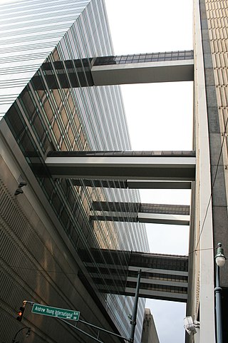
A skyway, skybridge, skywalk, or sky walkway is an elevated type of pedway connecting two or more buildings in an urban area, or connecting elevated points within mountainous recreational zones. Urban skyways very often take the form of enclosed or covered footbridges that protect pedestrians from the weather. Open-top modern skyways in mountains now often have glass bottoms. Sometimes enclosed urban skywalks are made almost totally from glass, including ceilings, walls and floors. Also, some urban skyways function strictly as linear parks designed for walking.

Pioneer Square is a neighborhood in the southwest corner of Downtown Seattle, Washington, US. It was once the heart of the city: Seattle's founders settled there in 1852, following a brief six-month settlement at Alki Point on the far side of Elliott Bay. The early structures in the neighborhood were mostly wooden, and nearly all burned in the Great Seattle Fire of 1889. By the end of 1890, dozens of brick and stone buildings had been erected in their stead; to this day, the architectural character of the neighborhood derives from these late 19th century buildings, mostly examples of Richardsonian Romanesque.

An underground city is a series of linked subterranean spaces that may provide a defensive refuge; a place for living, working or shopping; a transit system; mausolea; wine or storage cellars; cisterns or drainage channels; or several of these. Underground cities may be currently active modern creations or they may be historic including ancient sites, some of which may be entirely or partially open to the public.
History of Seattle, Washington 1900–1940: Seattle experienced rapid growth and transformation in the early 20th century, establishing itself as a leader in the Pacific Northwest. The Klondike Gold Rush led to massive immigration, diversifying the city's ethnic mix with arrivals of Japanese, Filipinos, Europeans, and European-Americans. The city expanded geographically through annexations and ambitious regrade projects, most notably the Denny Regrade which leveled more than 120 feet of Denny Hill. Major infrastructure projects shaped the city, including the construction of the Lake Washington Ship Canal and the development of an extensive park system designed by the Olmsted Brothers. The Alaska-Yukon-Pacific Exposition of 1909 celebrated the city's rise, while the completion of Smith Tower in 1914 gave Seattle the tallest building west of the Mississippi River.

The street layout of Seattle is based on a series of disjointed rectangular street grids. Most of Seattle and King County use a single street grid, oriented on true north. Near the center of the city, various land claims were platted in the 19th century with differently oriented grids, which still survive today. Distinctly oriented grids also exist in some cities annexed by Seattle in the early 20th century, such as Ballard and Georgetown. A small number of streets and roads are exceptions to the grid pattern.

Path is a network of underground pedestrian tunnels, elevated walkways, and at-grade walkways connecting the office towers of Downtown Toronto, Ontario, Canada. It connects more than 70 buildings via 30 kilometres (19 mi) of tunnels, walkways, and shopping areas. According to Guinness World Records, Path is the largest underground shopping complex in the world, with 371,600 square metres (4,000,000 sq ft) of retail space which includes over 1,200 retail fronts (2016). As of 2016, over 200,000 residents and workers use the Path system daily with the number of private dwellings within walking distance at 30,115.

The Rayburn House Office Building (RHOB) is a congressional office building for the U.S. House of Representatives in the Capitol Hill neighborhood of Washington, D.C., between South Capitol Street and First Street.

A utility vault is an underground room providing access to subterranean public utility equipment, such as valves for water or natural gas pipes, or switchgear for electrical or telecommunications equipment. A vault is often accessible directly from a street, sidewalk or other outdoor space, thereby distinct from a basement of a building.
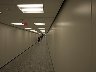
The Houston tunnel system is a network of subterranean, climate-controlled, pedestrian walkways that links 95 full city blocks 20 feet (6 m) below Houston's downtown streets. It is approximately six miles (9.7 km) long. There are similar systems in Chicago, Dallas, Oklahoma City, Montreal, and Toronto. Architectural historian Stephen Fox has stated that the idea for the tunnel system came when the Bank of the Southwest Building was "linked by tunnel to the 1010 Garage and the Mellie Esperson Building" in 1961.

William C Speidel was a columnist for The Seattle Times and a self-made historian who wrote the books Sons of the Profits and Doc Maynard, The Man Who Invented Seattle about the people who settled and built Seattle, Washington.
Lou Graham, born Dorothea Georgine Emile Ohben, was a German-born woman who became famous as the madam of a brothel in what is now the Pioneer Square district of Seattle, Washington, United States. She was referred to as the "Queen of the Lava Beds", with "lava beds" referring to the area of tide flats that were filled in with sawdust from the sawmill. She became one of the city's wealthiest citizens before dying in her forties.
Henry Leiter Yesler was an American entrepreneur and a politician, regarded as a founder of the city of Seattle. Yesler served two non-consecutive terms as Mayor of Seattle, and was the city's wealthiest resident during his lifetime.

The Pioneer Building is a Richardsonian Romanesque stone, red brick, terra cotta, and cast iron building located on the northeast corner of First Avenue and James Street, in Seattle's Pioneer Square District. Completed in 1892, the Pioneer Building was designed by architect Elmer Fisher, who designed several of the historic district's new buildings following the Great Seattle Fire of 1889.

Westlake station is a light rail station that is part of the Downtown Seattle Transit Tunnel in Seattle, Washington, United States. The station is located under Pine Street between 3rd and 6th avenues in Downtown Seattle, near Westlake Center and Westlake Park. It is served by the 1 Line, part of Sound Transit's Link light rail system, and also connected above ground by buses at several stops, the South Lake Union Streetcar, and the Seattle Center Monorail.

Joshua Green was an American sternwheeler captain, businessman, and banker. He rose from being a seaman to being the dominant figure of the Puget Sound Mosquito Fleet, then sold out his interests and became a banker. Living to the age of 105 and active in business almost to the end of his life, he became an invaluable source of information about the history of Seattle and the Puget Sound region. According to Nard Jones, Green was one of the city of Seattle's last fluent speakers of Chinook Jargon, the pidgin trade language of the Pacific Northwest.

The Colonial Hotel is a historic building in Seattle located at 1119-1123 at the southwest corner of 1st Avenue and Seneca Streets in the city's central business district. The majority of the building recognizable today was constructed in 1901 over a previous building built in 1892-3 that was never completed to its full plans.
Vaulted sidewalks, also called sidewalk vaults and areaways are sidewalks that are not placed directly on the ground. Rather, there is an empty space below them where the ground level used to be. This may happen where the street level has been raised over time, or where basements are extended, or as utility vaults.

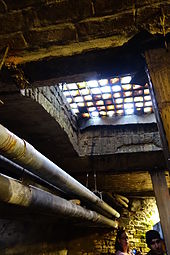
Pavement lights (UK), vault lights (US), floor lights, or sidewalk prisms are flat-topped walk-on skylights, usually set into pavement (sidewalks) or floors to let sunlight into the space below. They often use anidolic lighting prisms to throw the light sideways under the building. They were developed in the 19th century, but declined in popularity with the advent of cheap electric lighting in the early 20th. Older cities and smaller centers around the world have, or once had, pavement lights. In the early 21st century, such lights are approximately a century old, although lights are being installed in some new construction.

The Mutual Life Building, originally known as the Yesler Building, is an historic office building located in Seattle's Pioneer Square neighborhood that anchors the West side of the square. The building sits on one of the most historic sites in the city; the original location of Henry Yesler's cookhouse that served his sawmill in the early 1850s and was one of Seattle's first community gathering spaces. It was also the site of the first sermon delivered and first lawsuit tried in King County. By the late 1880s Yesler had replaced the old shanties with several substantial brick buildings including the grand Yesler-Leary Building, which would all be destroyed by the Great Seattle Fire in 1889. The realignment of First Avenue to reconcile Seattle's clashing street grids immediately after the fire would split Yesler's corner into two pieces; the severed eastern corner would become part of Pioneer Square park, and on the western lot Yesler would begin construction of his eponymous block in 1890 to house the First National Bank, which had previously been located in the Yesler-Leary Building. Portland brewer Louis Feurer began construction of a conjoined building to the west of Yesler's at the same time. Progress of both would be stunted and the original plans of architect Elmer H. Fisher were dropped by the time construction resumed in 1892. It would take 4 phases and 4 different architects before the building reached its final form in 1905. The Mutual Life Insurance Company of New York only owned the building from 1896 to 1909, but it would retain their name even after the company moved out in 1916.
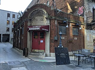
Ringside Café is a restaurant and bar in Downtown Columbus, Ohio. The restaurant is considered the oldest bar or restaurant in Downtown Columbus, having opened in 1897 and operated continuously since then. The restaurant has always been an attraction of politicians, lawyers, reporters, and lobbyists, given its proximity to the Ohio Statehouse, Columbus City Hall, and other government buildings.