Seaview, Lower Hutt

Last updated

Seaview
Miss Fortune's, Seaview, 29 November 2020.png
Seaview, Lower Hutt
CountryNew Zealand
City Lower Hutt
Local authority Hutt City Council
Electoral wardHarbour
Community board Petone Community Board [1]
Petone Moera Gracefield
Pfeil oben.svg
Pfeil links.svgSeaviewPfeil rechts.svg
Pfeil unten.svg
Eastbourne Sorrento Bay

Seaview is an industrial suburb of the city of Lower Hutt, in Wellington, New Zealand. [2] Situated on the eastern coast of the Hutt Valley, the suburb lies between Te Awa Kairangi / the Hutt River and Petone (to the west), and the bays of Eastbourne to the south. Seaview is a centre for bulk liquid fuel storage for the lower half of the North Island, and a site for heavy industry. It is also a base for support services for trucks and transportation businesses and the location of the wastewater treatment plant for drainage from the Hutt Valley. Seaview is home to the Port Road Drags, the longest-running street drag races in Australasia.

Contents

History

In the first half of the nineteenth century there were two pā at Seaview. Ngāti Ira people lived at a pā called Ohiti or Owhiti which was later taken over by Te Āti Awa. [3] It was situated where the Ford factory would later be built. [4] Te Āti Awa had another settlement, Waiwhetū Pā, which was on a sandy, windswept spit at the eastern side of the mouth of the Waiwhetu Stream where it joined the Hutt River. [3] [5] [6] The Waiwhetū Stream was navigable well into the Hutt Valley, [7] providing food and ease of movement for the people at the pā. The population decreased in the 1840s after a local chief was murdered by Māori from the Wairarapa, and by 1850 only 48 people lived at Waiwhetū Pā. [8] [9] European settlers arrived after 1840 and by 1848 there were several ship-building yards on the Waiwhetū Stream. [10] [11] [12] Māori operated a ferry service by canoe across the Waiwhetū Stream in the 1840s. [13]

However, disaster struck when the 1855 Wairarapa earthquake occurred, changing the river into the low-lying stream it is today, and making the area a desolate strip of swampland. The local shipyards were destroyed, and Pākehā settlers focused their efforts on Petone instead. A government report in 1861 stated that only 20 Māori then lived in the Waiwhetū area: 10 Ngati-te-umo-Rangi led by Te Wiremu Uenukutara, and 10 Hamua led by Ropiha Moturoa. [14] [15] Today a Māori cemetery, Owhiti Urupā, remains on the site of the former Waiwhetū Pā. [16]

Seaview remained undeveloped until 1929, when Lower Hutt Borough Council reclaimed land and constructed Seaview Road to provide a more direct route to the eastern bays and access to a new heavy industrial zone to be developed in the area. [17] [18] A drainage and sewage scheme was put in place and plans were made for bridges and more reclamation. [19] Meanwhile, the Texas Company (now Caltex) built a fuel processing plant in 1929, fronting the new Seaview Road that was still under construction. [20] Companies making pipes and other products were soon established nearby. [18] Between 1936 and 1939, an additional 94 acres of land was reclaimed from swamp and estuary at the mouth of the Hutt River, [21] and more manufacturing industries started moving into the area. Ford opened a car-assembly factory on Seaview Road in 1936, [22] and British Australian Lead Manufacturers (now Dulux) established a paint manufacturing plant in 1937. [23] These were followed by more companies making industrial goods such as bolts, rivets and chemicals, both in Seaview and the adjacent suburb of Gracefield.

During World War 2, the United states arranged for car-assembly plants in Petone and Seaview (Ford) to become repair shops for US forces vehicles damaged during the war in the Pacific. Vehicles were stripped down and, where possible, reconditioned and sent back to active duty. At the end of the war the United States declared that the 2287 vehicles still stored in Seaview were surplus to their requirements. The vehicles were stacked bumper-to-bumper, with jeeps on top of truck beds, in a yard opposite the Ford factory. The New Zealand government agreed to buy the vehicles and spare parts from the United States, with a view to on-selling them to New Zealand car assemblers, but the car assemblers were not interested because of the state of the vehicles, the difficulty of getting spare parts and their specialised military nature. [24] G.T. Gillies bought over 1200 of the vehicles and the 18 acres they were stored on in Seaview Road, and spent over 10 years fixing or disposing of them. [25] [26]

The Hutt Estuary Bridge was built across the Hutt River in 1954 to replace a 1912 bridge, improving the connection between Seaview and Petone. [27] More land was reclaimed from 1955. As of 2024, Seaview is a centre for bulk liquid fuel storage and heavy industry, and is also a base for support services for trucks and transportation businesses. [28]

Ford Motor Company workshop

In 1936, the Ford Motor Company built a large, modern vehicle assembly plant on a 13 acre site in Seaview Road. Imported car parts were welded together, finished, upholstery was made and fitted and the whole vehicle assembled in the 3.5 acre building. By the time of its official opening on 7 April 1937, the factory employed between 600 and 700 men who were producing 40 vehicles per day. Another 40 men and women worked in the company's offices. [29] The building was designed by architects Dawson and King for efficiency and the comfort of employees. It is constructed of brick with steel framing, with large windows and skylights for maximum natural light. The largest neon sign in the southern hemisphere was mounted on the roof, facing Seaview Road and out over the harbour. It was said to be visible from Wellington city. [30]

Over the years the factory produced various models of car including the Prefect, Anglia, Cortina, Zephyr and Zodiac, and Fordson tractors. During World War 2, arms, explosives and jeeps were produced at the factory. [31]

In 1988 the factory closed when production shifted to Auckland. Ford employed about 700 staff at the time the closure was announced in February 1986, but as the plant wound down the number of employees dropped, and by the time of the final closure in 1988 there were about 300 employees. [32] :3–4 Many car assembly firms and other manufacturing businesses in the region had closed in the 1970s and 1980s: for example, in Petone, New Zealand Motor Bodies (closed 1978), Austin Motors (1983), and General Motors (1984). In the context of the declining manufacturing sector, closure of the Ford plant was seen as a significant event for the regional economy, for businesses supplying the plant, [33] and for the well-being and financial situations of the workers. [34] [35]

Other companies later operated from the building, and in 2016 it was refurbished and earthquake-strengthened. [36] The building was listed by Heritage New Zealand as a 'Historic Place Category 2' in 1984. [31]

Demographics

Very few people live in Seaview, as it is zoned for heavy industry. Seaview is included in the Gracefield statistical area. [37]

Port Road Drags

Port Road Drags, which is held in Port Road in Seaview, is the longest-running street drag racing event in Australasia. The first event was organised by the Hutt Valley Motoring Club in March 1966. [38] The Wellington Hot Rod Club formed later that year, and the races have taken place along Port Road in November each year since then. Much of Port Road is closed off for the event, and classic cars fill Wellington on their way to Seaview on the day. Drag enthusiasts travel from all over the country for the races. [39] In 2020, the event was called off early when a spectator was seriously injured. [40]

Seaview marina

Seaview marina is situated at the southern end of Seaview. It was built by Works Civil Construction in two stages in 1989 and 1991. The first stage involved building two breakwaters, a boat ramp and floating jetties, and in the second stage the seabed was dredged and the spoil used to reclaim land. [41] The marina is owned by Hutt City Council. [42] Lowry Bay Yacht Club is based at the marina, which has 360 berths for vessels of up to 26 m long and storage for 250 trailer boats. [43]

Seaview wharf

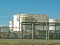
Seaview wharf is a marine fuel terminal at the north-east of Wellington Harbour. The fuel terminal is the main point of supply for liquid fuels for the lower North Island, and is also a backup point of supply for other parts of the North Island. The wharf was originally built around 1975, and is now owned by CentrePort Wellington. The landward end of the wharf is at Point Howard and it is approximately 600 metres (2,000 ft) long. Fuel pipelines along the wharf connect with bulk fuel storage facilities in Seaview. The fuel terminal handles approximately one million tonnes of fuel annually. [44]

The wharf was damaged in the 2016 Kaikōura earthquake, but was able to continue operating. In 2021 a $60m project was commenced to improve the seismic resilience of the wharf. [45]

Waiwhetū Stream

The lower reaches of Waiwhetū Stream pass through Seaview, and for decades it was used as an industrial sewer. In 1972, the stream caught fire because of the quantity of solvents that were being discharged. [46] [47] In 2001, despite 20 years having passed since the stopping of trade waste discharges from industries in the area, the river was still highly polluted with toxic sediments. [48] Mud in the stream bed down to a depth of 1.5 metres (4 ft 11 in) was heavily contaminated with lead, zinc, DDT and hydrocarbons including diesel, oil and petrol. In 2003, it was estimated that there was 30,000 cubic metres (1,100,000 cu ft) of heavily contaminated sediment in a short section of the stream between Seaview Road and the rail bridge just north of Hutt Park Holiday Village. Local groups urged that a clean-up be undertaken. [47] [49] A major clean-up project commenced in 2009 to remove 12,000 cubic metres (420,000 cu ft) of contaminated mud from the lower reaches of the stream. The work was funded by Hutt City Council, Greater Wellington Regional Council and the Ministry for the Environment, and cost over $20 million. At the time, the stream was described as one of the country's most polluted waterways. [50] The clean-up was declared complete in June 2010, after the removal of 56,000 tonnes of toxic waste. [51]

Wastewater treatment plant and outfall

Prior to 2001, wastewater from the entire Hutt Valley was screened and then pumped without any further treatment via a pipeline along the eastern coastline of Wellington Harbour to an ocean outfall near the harbour entrance at Pencarrow Head. By the 1990s, the discharge of untreated sewage into the ocean had become environmentally unacceptable. [52] Planning for a new sewage treatment plan began in the mid 1990s. In 1998, tenders were called for a design, build and operate contract for a treatment plant to be built in Seaview that would provide secondary treatment of all sewage from the Hutt Valley and Wainuiomata. [52] It was to be located close to the Waiwhetū Stream. A contract was let in 1999, [53] and the plant was commissioned in 2001. [54]

In March 2022, Wellington Water reported a leak in the pipeline to the outfall, in the Seaview area. Repairs required the shutdown of the pipeline, and the discharge of fully treated wastewater into Waiwhetū Stream while the repairs were carried out. [55] In September 2023, Wellington Water predicted that pipeline shutdowns for repairs will become increasingly frequent, possibly rising to 30 times per year, with a typical repair time of 1 week, leading to repeated discharges of treated wastewater into the Waiwhetū Stream. Options presented to the Hutt City and Upper Hutt councils included refurbishment of the existing pipeline, or the construction of a new pipeline in Wellington Harbour. The forecast costs of a new outfall pipeline were approximately $700 million, with a further $300 million required for upgrades to the Seaview treatment plant, including a replacement sludge drier. [56]

Related Research Articles

<span class="mw-page-title-main">Eastbourne, New Zealand</span> Suburb of Lower Hutt, New Zealand

Eastbourne is a suburb of Lower Hutt, a part of Wellington, New Zealand. Lying beside the sea, it is a popular local tourist destination via car from Petone or from ferry crossings from central Wellington. An outer suburb, it lies on the eastern shore of Wellington Harbour, five kilometres south of the main Lower Hutt urban area and directly across the harbour from the Miramar Peninsula in Wellington city. A narrow exposed coastal road connects it with the rest of Lower Hutt via the Eastern Bays and the industrial suburb of Seaview. It is named for Eastbourne in England, another seaside town known as a destination for day-trips.

<span class="mw-page-title-main">Hutt River (New Zealand)</span> River in New Zealand

The Hutt River flows through the southern North Island of New Zealand. It flows south-west from the southern Tararua Range for 56 kilometres (35 mi), forming a number of fertile floodplains, including Kaitoke, central Upper Hutt and Lower Hutt.

<span class="mw-page-title-main">Petone</span> Suburb of Lower Hutt, New Zealand

Petone is a large suburb of Lower Hutt, Wellington. It stands at the southern end of the Hutt Valley, on the northern shore of Wellington Harbour.

<span class="mw-page-title-main">Wainuiomata</span> Town in Lower Hutt, New Zealand

Wainuiomata is a large dormitory suburb of Lower Hutt, in the Wellington metropolitan area in New Zealand. Its population was estimated as being 19,840 as of June 2023, with a density of 1,600 people per km2. European settlement of Wainuiomata began in the 1850s with timber-felling and farming and began to grow in the 1920s. After World War 2 there was rapid population expansion, with Wainuiomata earning the nickname 'Nappy Valley' because of the large number of families with young children. From the late 1980s the economy slowed and the population decreased, but since about 2020 there has been a housing boom and corresponding increase in population. Wainuiomata is noted for being the origin of New Zealand's kōhanga reo movement.

<span class="mw-page-title-main">Wellington Harbour</span> Harbour in New Zealand

Wellington Harbour is a large natural harbour on the southern tip of New Zealand's North Island. The harbour entrance is from Cook Strait. Central Wellington is located on parts of the western and southern sides of the harbour, and the suburban area of Lower Hutt is to the north and east.

<span class="mw-page-title-main">Matiu / Somes Island</span> Island in Wellington, New Zealand

Matiu / Somes Island is the largest of three islands in the northern half of Wellington Harbour, New Zealand. The island is 24.9 hectares in area, and lies 3 kilometres south of the suburb of Petone and the mouth of the Hutt River.

<span class="mw-page-title-main">Hutt Valley Line</span> Train service in New Zealand

The Hutt Valley Line is the electrified train service operated by Transdev Wellington on behalf of Metlink on the section of the Wairarapa Line railway between Wellington and Upper Hutt, New Zealand.

<span class="mw-page-title-main">Moera</span> Suburb of Lower Hutt, New Zealand

Moera, a suburb of the city of Lower Hutt in New Zealand, forms part of the urban area of greater Wellington.

<span class="mw-page-title-main">Lower Hutt</span> City in Wellington, New Zealand

Lower Hutt is a city in the Wellington Region of New Zealand. Administered by the Hutt City Council, it is one of the four cities that constitute the Wellington metropolitan area.

Gracefield is an industrial suburb of Lower Hutt City, located at the bottom of the North Island of New Zealand.

<span class="mw-page-title-main">Automotive industry in New Zealand</span> Overview of the automotive industry in New Zealand

The automotive industry in New Zealand supplies a market which has always had one of the world's highest car ownership ratios. The distributors of new cars are essentially the former owners of the assembly businesses. At the dealership level they have maintained their old retail chains in spite of the establishment of the many new independent businesses built since the 1980s by specialists in used imports from Japan. Toyota entered into direct competition with those used-import businesses refurbishing old Toyotas from Japan and selling them through their own dealers as a special line. The nation's car fleet is accordingly somewhat older than in most developed countries.

<span class="mw-page-title-main">Wellington Harbour Board</span> Board elected to levy dues on goods passing through Wellington Harbour

Wellington Harbour Board was the body which formerly managed the shipping and commercial affairs of the port of Wellington in New Zealand. It was constituted in 1880 and was disestablished in 1989.

<span class="mw-page-title-main">Wainuiomata Tunnel</span> Planned tunnel in New Zealand

The Wainuiomata Tunnel was planned to improve access to the Wainuiomata Valley in the Wellington region of New Zealand’s North Island as part of a scheme to commence residential development there in the 1930s. Construction started in 1932 but was halted several years later when only partly completed due to a lack of funds brought about by economic depression.

<span class="mw-page-title-main">Lambton railway station</span> Defunct railway station in Wellington, New Zealand

Lambton railway station in Featherston Street, Wellington, New Zealand was the southern passenger terminus for the Hutt Valley Line and the Wairarapa Line from 1885 to 1936 and for lines further north until December 1908. It was originally known as Wellington railway station. Wellington's third railway station, it had been preceded by station buildings temporarily at Pipitea Point and a site further south on Featherston Street beside Wellington's rail freight depot and its Railway Wharf.

Water supply and sanitation in the Wellington region involves the provision of the "three waters" – drinking water, stormwater, and wastewater services in the Greater Wellington region.

<span class="mw-page-title-main">Gear Meat Company</span>

Gear Meat Company was a meat processing company with a large works that operated in Petone, New Zealand from 1874 until 1981 and was one of the major employers in Petone.

<span class="mw-page-title-main">Point Howard</span> Suburb of Lower Hutt, New Zealand

Point Howard is a suburb on the eastern side of Wellington Harbour, in Lower Hutt, New Zealand.

<span class="mw-page-title-main">Waiwhetu Aquifer</span> Aquifer in Wellington, New Zealand

The Waiwhetu artesian aquifer, sometimes referred to as the Hutt aquifer, is a pressurized zone of water-retaining sand, gravel and boulders beneath the Hutt Valley and Wellington Harbour in New Zealand. The aquifer provides about 40% of the public fresh water supply for Lower Hutt and Wellington city. Water from the Hutt River begins to flow underground south from Taita Gorge, then becomes pressurized under a seal of clay. Water is extracted from the pressurized area for public use, but concerns about overuse and damage by earthquakes have led to investigations of alternative sources of fresh water.

<span class="mw-page-title-main">Waiwhetū Stream</span> River in New Zealand

The Waiwhetū Stream is a small watercourse in Lower Hutt, in the North Island of New Zealand. The stream drains the eastern side of the Hutt Valley, and enters Wellington Harbour at the Hutt River estuary. Development and urbanisation of the Hutt Valley since the arrival of settlers led to increasing pollution and degradation of the stream environment. The stream was diverted into concrete culverts in some sections in an attempt to reduce flooding.

<span class="mw-page-title-main">Wharves in Wellington Harbour</span> Wharves in Wellington

Wharves in Wellington Harbour have been essential to the operation of the Port of Wellington and to the development of the city and the lower half of the North Island of New Zealand.

References

  1. "Community Boards". Hutt City Council . Retrieved 28 May 2023.
  2. "History and Vision Seaview of Lower Hutt, on HuttCity".
  3. 1 2 Adkin, G. Leslie (1959). The great harbour of Tara: Traditional Maori place-names and sites of Wellington Harbour and environs. New Zealand: Whitcombe and Tombs.
  4. "History". www.seaviewbusiness.co.nz. Retrieved 17 February 2024.
  5. Best, Elsdon (28 September 1894). "Wellington in pre-Pakeha days". New Zealand Mail via Papers Past.
  6. "Industrial area, Hutt Valley settlement [map]". ndhadeliver.natlib.govt.nz. 1939. Retrieved 16 February 2024.
  7. Jackson, H. H. (10 September 1883). "Reminiscences of the Early Wairarapa Settlers". Wairarapa Standard via Papers Past.
  8. "12th settlement - Waiwhetu". Wellington Independent. 31 August 1850 via Papers Past.
  9. "Early Wellington". New Zealand Mail. 27 May 1903 via Papers Past.
  10. "Untitled". New Zealand Spectator, and Cook's Strait Guardian. Vol. 4, no. 235. 30 October 1847. p. 2. A vessel built by Mr Wilcox on the Waiwetu river [...] is capable of carrying 120 tons of cargo.
  11. "[untitled]". New Zealand Spectator and Cook's Strait Guardian. 10 June 1846. p. 2 via Papers Past. A smart little craft of about seventeen tons [...] was built on the Waiwetu river by Mr R Williams.
  12. "Launch". New Zealand Spectator and Cook's Strait Guardian. 20 May 1848 via Papers Past. A new vessel was launched at Mr Mathieson's building yard on the Waiwetu river.
  13. "Original correspondence [Letter to editor]". New Zealand Spectator and Cook's Strait Guardian. 29 November 1845 via Papers Past.
  14. "Reports on the state of the Natives in various districts". Appendices to the Journals of the House of Representatives. Session 1, E 07: 25. 1862 via Papers Past.
  15. "Te Ropiha Moturoa". www.wcl.govt.nz. Retrieved 16 February 2024.
  16. "Owhiti urupā kaitiaki maintains traditions". E Tū Whānau. 2 May 2016. Retrieved 16 February 2024.
  17. "City and suburban". Dominion. 5 November 1929 via Papers Past.
  18. 1 2 "Not a dream". Evening Post. 29 May 1929 via Papers Past.
  19. "Development at Waiwetu". Dominion. 6 February 1930 via Papers Past.
  20. "Big oil plant". Evening Post. 25 February 1929 via Papers Past.
  21. "Reclamation work nears end". Dominion. 14 January 1939 via Papers Past.
  22. "£160,000 plant for Hutt Valley". 26 February 1936 via Papers Past.
  23. "Modern plant". Evening Post. 9 August 1937 via Papers Past.
  24. Report of the Royal Commission to inquire into and report upon certain matters arising out of the acquisition and disposal of surplus assets by the War Assets Realization Board (PDF). New Zealand Government. 1946.
  25. "Sales £87,157". Gisborne Herald. 27 August 1946 via Papers Past.
  26. "Army trucks reconditioned". Press. 8 December 1955 via Papers Past.
  27. "Hutt Estuary Bridge | Engineering New Zealand". www.engineeringnz.org. Retrieved 17 February 2024.
  28. "History". www.seaviewbusiness.co.nz. Retrieved 17 February 2024.
  29. "Forty cars a day". Evening Post. 8 April 1937 via Papers Past.
  30. Stokes, John (2020), Ford in New Zealand, vol. 2: Driving Ahead 1936 to 1997, New Holland Publishing, ISBN   9781869665357
  31. 1 2 "Ford Motor Company Workshop". New Zealand Heritage List/Rārangi Kōrero. Heritage New Zealand . Retrieved 17 February 2024.
  32. Wellington Regional Council (August 1987). Task force on closure of Ford vehicle assembly plant at Seaview [part 1] (PDF). Wellington, New Zealand.{{cite book}}: CS1 maint: location missing publisher (link)
  33. "Ford to offer few transfers". Press. 5 February 1986 via Papers Past.
  34. Wellington Regional Council (August 1987). Task force on closure of Ford vehicle assembly plant at Seaview [part 2] (PDF). Wellington, New Zealand.{{cite book}}: CS1 maint: location missing publisher (link)
  35. Wellington Regional Council (August 1987). Task force on closure of the Ford vehicle assembly plant at Seaview [part 3] (PDF). Wellington, New Zealand.{{cite book}}: CS1 maint: location missing publisher (link)
  36. Tso, Matt (21 March 2016). "Former Ford Seaview assembly plant to get upgrade when Placemakers move out". Stuff. Retrieved 17 February 2024.
  37. 2018 Census place summary: Gracefield
  38. "History". portroad.co.nz. Retrieved 17 February 2024.
  39. "History, speed and burnt rubber a drawcard for Port Road Drags". Stuff. 16 November 2017. Retrieved 29 November 2020.
  40. Cornish, Sophie; Witton, Bridie (30 November 2020). "Moment of Lower Hutt drag race crash that put spectator in hospital caught on film". Stuff. Retrieved 17 February 2024.
  41. Seaview Marina Construction [video] , retrieved 17 February 2024
  42. "Seaview Marina Ltd - Governance". www.seaviewmarina.co.nz. Retrieved 17 February 2024.
  43. "Seaview Marina". LBYC Website. Retrieved 17 February 2024.
  44. Juno, W.; Hall, L.; Delaney, A.; Terry, P. (2021). "Seaview Wharf: risk-based thinking underpins the future" (PDF). NZ Society for Earthquake Engineering.
  45. Tso, Matthew (27 June 2021). "$80m quake-resilience upgrade for lower North Island's fuel supply line in Lower Hutt". Stuff. Retrieved 27 May 2023.
  46. "Take me to the river ..." Good Magazine. 2 June 2017.
  47. 1 2 Schouten, Hank (19 March 2002). "Cleaning filthy Hutt stream has big price tag". Evening Post . ProQuest   314846534.
  48. Schouten, Hank (10 May 2001). "Toxic study step to Waiwhetu Stream cleanup". Evening Post . ProQuest   314751986.
  49. Scanlon, Sean (7 October 2003). "Waiwhetu Stream group pushes for urgent cleanup". Evening Post . ProQuest   338021582.
  50. "Budget blowout in cleanup of toxic Waiwhetu Stream". Dominion Post . 1 February 2010. ProQuest   507114045.
  51. "Stream clean-up complete". RNZ . 18 June 2010. Archived from the original on 14 May 2023. Retrieved 14 May 2023.
  52. 1 2 Schouten, Hank (16 March 1998). "Seven signal Hutt sewage interest". Evening Post . ProQuest   314533367.
  53. Schouten, Hank (24 November 1999). "Hutt sewage plant cheaper". Evening Post . ProQuest   314635961.
  54. "Report card for Seaview sewage plant". Evening Post . 14 November 2001. ProQuest   314817886.
  55. "Wastewater discharging from broken pipeline into Waiwhetu Stream". Scoop. 9 March 2022. Archived from the original on 12 March 2022. Retrieved 21 May 2022.
  56. Boyack, Nicholas (23 September 2023). "$1 billion shock for Hutt Valley ratepayers" . www.thepost.co.nz. Retrieved 24 September 2023.

41°14′28″S174°54′22″E / 41.241°S 174.906°E / -41.241; 174.906