
Green Oaks is a village in Libertyville Township, Lake County, Illinois, United States. The population was 3,866 at the 2010 census.
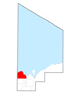
Onota Township is a civil township of Alger County in the U.S. state of Michigan. As of the 2010 census, the township population was 352.

Rock River Township is a civil township of Alger County in the U.S. state of Michigan. The population was 1,212 at the 2010 census.

There are two streams named Salmon Trout River in the Upper Peninsula of the U.S. state of Michigan.

The city of Chicago is located in northern Illinois, United States, at the south western tip of Lake Michigan. It sits on the Saint Lawrence Seaway continental divide at the site of the Chicago Portage, an ancient trade route connecting the Mississippi River and the Great Lakes watersheds.

Hagemeister Park was the name of a park in Green Bay, Wisconsin. It was the home of the Green Bay Packers from their founding in 1919 and their first two seasons playing in the National Football League, 1921 and 1922.

The Root River is a 43.7-mile-long (70.3 km) river that flows to Lake Michigan at the city of Racine in southeastern Wisconsin in the United States. Racine and Racine County are named for the river, as racine is the French word for root.

The East Twin River, formerly the Mishicot River, is a 41.1-mile-long (66.1 km) river in east-central Wisconsin that is a tributary to Lake Michigan. It merges with the West Twin River in the city of Two Rivers at its mouth with the lake. The source of the river is located in central Kewaunee County. On its course it passes through the villages of Mishicot and Tisch Mills. Its tributaries include Jambo Creek and Tisch Mills Creek.
Black River is a 29.8-mile-long (48.0 km) river on the Upper Peninsula of the U.S. state of Michigan. The river flows into the Middle Branch Escanaba River in Ely Township of Marquette County at 46°23′53″N87°46′15″W and on into Lake Michigan.
The Laughing Whitefish River is a 19.4-mile-long (31.2 km) stream located on the Upper Peninsula of the U.S. state of Michigan. The river rises in eastern Marquette County and flows east and then north through Alger County to its mouth on Lake Superior at 46°31′30″N87°01′43″W a few miles north of Deerton, Michigan. The total watershed of the Laughing Whitefish River is 36 square miles (93 km2).
Chopawamsic Creek is a 6.8-mile-long (10.9 km) tributary of the Potomac River in Prince William and Stafford counties, Virginia. Chopawamsic Creek is formed by the confluence of the North and South Branches of Chopawamsic Creek and empties into the Potomac River south of Quantico at the Marine Corps Base Quantico's Air Station. Breckenridge Reservoir lies at the stream's confluence with the North and South Branches. Along with its North Branch, Chopawamsic Creek forms part of the boundary between Prince William and Stafford counties. The North Branch flows through part of the Chopawamsic Backcountry Area in Prince William Forest Park.

The Presque Isle River runs 42.1 miles (67.8 km) through the Upper Peninsula of Michigan and empties into Lake Superior. Along its course, it flows through the Ottawa National Forest and Porcupine Mountains Wilderness State Park. It has 300 square miles (780 km2) of drainage area in Upper Michigan and northern Wisconsin.
The Whitefish River is an 11.9-mile-long (19.2 km) river on the Upper Peninsula of the U.S. state of Michigan. The mouth of the river is in Delta County at 45°54′34″N86°58′01″W on the Little Bay De Noc of Lake Michigan. The main branch of the river is formed by the confluence of the east and west branches at 46°03′25″N86°52′17″W.

Ahtanum Ridge is a long anticline mountain ridge in Yakima County in the U.S. state of Washington. It is located just south of the city of Yakima, and much of its length is at the northern edge of the Yakama Indian Reservation.
The Chocolay River is a 21.7-mile-long (34.9 km) tributary of Lake Superior in Marquette County on the Upper Peninsula of Michigan in the United States. It forms at the confluence of its West and East Branches west of Skandia and flows generally north, then west, to Lake Superior at the village of Harvey, 3 miles (5 km) southeast of the city of Marquette.
The Cliff River is a 6.8-mile-long (10.9 km) river on the Upper Peninsula of Michigan in the United States. It is a tributary of Mountain Lake, which drains by Mountain Stream to Pine Lake, which in turn drains by the Pine River to Lake Superior.
The Greene County Nuclear Power Plant was proposed in 1974 by the Power Authority of the State of New York. A single 1,212 MWe Babcock & Wilcox pressurized water reactor was to be built approximately 5 miles south of Catskill, New York on the western shore of the Hudson River, but the plant proposal was canceled in 1979, largely due to concerns over social and economic disruptions to the local communities.

Indian River is a 59.1-mile-long (95.1 km) tributary of the Manistique River on the Upper Peninsula of Michigan in the United States. It rises out of Hovey Lake at 46°17′36″N86°42′20″W on Hiawatha National Forest land in Alger County and flows south and east through a lake district and on through Schoolcraft County. The river flows into the 8,659 acre (35 km²) Indian Lake at 46°17′36″N86°42′20″W and flows out at 45°59′30″N86°17′15″W. It then flows east and south about 2.5 miles where it merges with the Manistique River, which then flows through Manistique and into Lake Michigan at 45°56′56″N86°14′45″W.
The River Styx is a 0.6-mile-long (1.0 km) stream in Marquette County, Michigan, in the United States. It flows from the outlet of Ives Lake north over a waterfall to Third Lake, an arm of Pine Lake. Via the Pine River, water from the River Styx flows to Lake Superior.


