Sefton Coast

Last updated
Sefton Coast
Site of Special Scientific Interest
Natterjack Toads live here^ - geograph.org.uk - 5719.jpg
Merseyside UK location map.svg
Red pog.svg
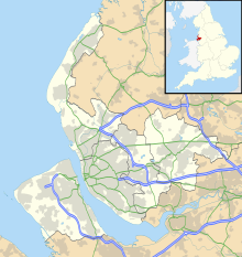
Location within Merseyside
Area of Search Merseyside
Grid reference SD295106
Coordinates 53°35′06″N3°03′40″W / 53.585°N 3.061°W / 53.585; -3.061 Coordinates: 53°35′06″N3°03′40″W / 53.585°N 3.061°W / 53.585; -3.061
Interest Biological and Geological
Area 4605.32 hectares, 11,380 acres (46,100,000 m2)
Notification 16 August 2000
Natural England website

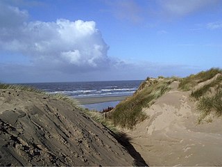
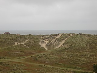
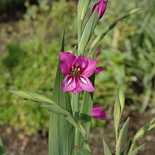
Sefton Coast is a 4605.3 hectare (11379.9 acre) Site of special scientific interest which stretches for 12 miles (20 km) between Southport and Waterloo, which is end location of Crosby Beach. The site was notified in 2000 for both its biological and geological features. The coast has species such as grass of Parnassus, wild orchids, rare butterflies, sand lizards, natterjack toads and waders. [1]

Southport seaside town in the Metropolitan Borough of Sefton, England

Southport is a large seaside town in Merseyside, England. At the 2001 census, it had a population of 90,336, making it the eleventh most populous settlement in North West England.

Waterloo, Merseyside area of the Metropolitan Borough of Sefton in Merseyside, England

Waterloo is an area of the Metropolitan Borough of Sefton, in Merseyside, England. Along with Seaforth the two localities make up the Sefton Ward of Church. The area is bordered by Crosby to the north, Seaforth to the south, the Rimrose Valley country park to the east, and to the west the Crosby Beach and Crosby Coastal Park.

Crosby Beach

Crosby Beach is part of the Merseyside coastline north of Liverpool in the Metropolitan Borough of Sefton, England, stretching about 2.5 miles (4.0 km) North-West from the Seaforth Dock in the Port of Liverpool, through Waterloo, where it separates the sea from the Marina. The beach has been the permanent home of the Another Place sculptures by Antony Gormley since 2007.

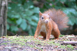
Sefton Coast includes Crosby beach which is also the site of an art installation by Antony Gormley, called Another Place. Further north is the National Trust site of Formby Point containing pinewoods and sand dunes. [2] The whole of the coastline here is managed as a Special Area of Conservation(SAC) [3] for its important wildlife reserves by Sefton Coast Partnership. The pine woods at Victoria Road have been established as a National Trust reserve for the red squirrel, listed on the endangered species list. Formby is one of several sites in Britain where the red squirrel can still be found although it is now being threatened by the grey squirrel. [4]

Antony Gormley British sculptor

Sir Antony Mark David Gormley,, is a British sculptor. His best known works include the Angel of the North, a public sculpture in Gateshead in the North of England, commissioned in 1994 and erected in February 1998, Another Place on Crosby Beach near Liverpool, and Event Horizon, a multi-part site installation which premiered in London in 2007, around Madison Square in New York City, in 2010, in São Paulo, Brazil, in 2012, and in Hong Kong in 2015–16.

<i>Another Place</i> (sculpture)

Another Place is a piece of modern sculpture by Sir Antony Gormley located at Crosby Beach in Merseyside, England. It consists of 100 cast iron figures facing towards the sea. The figures are modelled on the artist's own naked body. The work proved controversial due to the naked statues but has increased tourism to the beach. After being exhibited at two other locations in space meeting by Sefton Metropolitan Borough Council on 7 March 2007 decided that the sculptures should be permanently installed at the beach.

A Special Area of Conservation (SAC) is defined in the European Union's Habitats Directive (92/43/EEC), also known as the Directive on the Conservation of Natural Habitats and of Wild Fauna and Flora. They are to protect the 220 habitats and approximately 1000 species listed in annex I and II of the directive which are considered to be of European interest following criteria given in the directive. They must be chosen from the Sites of Community Importance by the State Members and designated SAC by an act assuring the conservation measures of the natural habitat.

The coast is also famous for the presence of Natterjack toads in Formby. Formby is only one of a few sites in England where they will breed. Later in the evening the male's distinctive song can be heard and is known locally as the 'Bootle Organ'. In spring the males gather at the edge of shallow pools in the dune slacks and sing to attract a mate. The Sefton Coast and Countryside Service are working hard to keep these pools from growing over so that they are ready each spring for this annual event. [5]

Natterjack toad species of amphibian

The natterjack toad is a toad native to sandy and heathland areas of Europe. Adults are 60–70 mm in length and are distinguished from common toads by a yellow line down the middle of the back, and parallel paratoid glands. They have relatively short legs, and this gives them a distinctive gait, contrasting with the hopping movement of many other toad species.

Bootle town within the Metropolitan Borough of Sefton in Merseyside, England

Bootle is a town in the Metropolitan Borough of Sefton, Merseyside, England, which in 2011 had a population of 51,394; a wider definition of the area, as covered by the Bootle UK Parliamentary constituency, had a population of 98,449.


Related Research Articles

Holkham National Nature Reserve nature reserve in the United Kingdom

Holkham National Nature Reserve is England's largest national nature reserve (NNR). It is on the Norfolk coast between Burnham Overy Staithe and Blakeney, and is managed by Natural England with the cooperation of the Holkham Estate. Its 3,900 hectares comprise a wide range of habitats, including grazing marsh, woodland, salt marsh, sand dunes and foreshore. The reserve is part of the North Norfolk Coast Site of Special Scientific Interest, and the larger area is additionally protected through Natura 2000, Special Protection Area (SPA) and Ramsar listings, and is part of both an Area of Outstanding Natural Beauty (AONB) and a World Biosphere Reserve. Holkham NNR is important for its wintering wildfowl, especially pink-footed geese, Eurasian wigeon and brant geese, but it also has breeding waders, and attracts many migrating birds in autumn. A number of scarce invertebrates and plants can be found in the dunes, and the reserve is one of the only two sites in the UK to have an antlion colony.

Studland village and civil parish in Dorset, England

Studland is a village and civil parish on the Isle of Purbeck in the English county of Dorset. It is famous for its beaches and nature reserve. It lies within the Purbeck administrative district, and is located about 2 miles (3.2 km) north of the town of Swanage, over a steep chalk ridge, and 3 miles (4.8 km) south of the South East Dorset conurbation at Sandbanks, but separated from it by Poole Harbour. The parish includes Brownsea Island within the harbour. In the 2011 census the parish had 182 households and a population of 425, though many of the houses in the village are holiday homes, second homes, or guest houses, and the village's population varies depending upon the season.

Formby civil parish and town within the Metropolitan Borough of Sefton in Merseyside, England

Formby is an affluent civil parish and town in the Metropolitan Borough of Sefton, Merseyside, England, which had a population of 22,419 at the 2011 Census.

Freshfield human settlement in United Kingdom

Freshfield is an area of Formby, in the Metropolitan Borough of Sefton, Merseyside, England, situated at the northern end of the town. It has no local political distinction or representation and is included as part of the two council wards which make up Formby, nor is it any longer separated in a physical sense from the town.

Gibraltar Point nature reserve in the United Kingdom

Gibraltar Point national nature reserve is an area of approximately 4.3 km2 (1.7 sq mi) in Lincolnshire, England.

Winterton Dunes

Winterton Dunes is an extensive dune system on the east coast of Norfolk, England, which has been designated as a National Nature Reserve of 109 ha. Winterton Dunes is within the Norfolk Coast AONB.

Sandwich Bay is a long sweeping inlet of the sea between Ramsgate and Deal, on the east coast of Kent, England. The coastal area consists of sand flats with their associated salt marshes and coastal sand dunes. The Sandwich Flats stretch for about five miles (8 km) along the coast. The coastal habitats are of high ecological importance.

Priddy Mineries

Priddy Mineries is a nature reserve previously run by the Somerset Wildlife Trust. It is in the village of Priddy, on the Mendip Hills in Somerset.

Saltfleetby-Theddlethorpe Dunes National Nature Reserve

Saltfleetby-Theddlethorpe Dunes is a national nature reserve on the coast of Lincolnshire, England, in the parishes of Saltfleetby and Theddlethorpe. It is managed in part by Natural England; in part by the Lincolnshire Wildlife Trust, and consists of 1,377 acres (557 ha) of sand dunes, salt marsh, sand and mudflats. It is on Rimac Road and sometimes referred to as Rimac.

Red Rocks (SSSI)

Red Rocks (SSSI) is an area of sand dunes and reedbeds at the mouth of the Dee Estuary and to the west of Hoylake on the Wirral Peninsula, England.

North Walney is a National Nature Reserve on Walney Island, England. The reserve, which has an area of 646.5 ha, is notable as a habitat of Natterjack Toads. It is one of the sites in the Duddon Estuary which support one fifth of the national population of the rare amphibian.

Sandscale Haws

Sandscale Haws is a national nature reserve on the Duddon Estuary, Cumbria, England. It is managed by the National Trust. Resident species include the natterjack toad.

Nature reserves in the North Norfolk Coast Site of Special Scientific Interest

The North Norfolk Coast Site of Special Scientific Interest (SSSI) is an internationally important protected area in Norfolk, England. The SSSI is a long, narrow strip of coastal land that starts between Old Hunstanton and Holme-next-the-Sea, and runs east for about 43 km (27 mi) to Kelling. The southern boundary runs roughly west to east except where it detours around towns and villages, and never crosses the A149 coast road. It has an area of 7,700 ha (19,027 acres), and is additionally protected through Natura 2000, Special Protection Area (SPA) and Ramsar listings; it is also part of the Norfolk Coast Area of Outstanding Natural Beauty (AONB). Scolt Head Island and the coast from the Holkham National Nature Reserve to Salthouse are a Biosphere Reserve.

North Norfolk Coast Site of Special Scientific Interest

The North Norfolk Coast Site of Special Scientific Interest (SSSI) is an area of European importance for wildlife in Norfolk, England. It comprises 7,700 ha (19,027 acres) of the county's north coast from just west of Holme-next-the-Sea to Kelling, and is additionally protected through Natura 2000, Special Protection Area (SPA) listings; it is also part of the Norfolk Coast Area of Outstanding Natural Beauty (AONB). The North Norfolk Coast is also designated as a wetland of international importance on the Ramsar list and most of it is a Biosphere Reserve.

Suffolk Coast National Nature Reserve

Suffolk Coast National Nature Reserve is a wildlife reserve on the North Sea coast of the English county of Suffolk. It is located around the village of Walberswick to the south of the town of Southwold. The reserve was designated in 2003, combining the existing Walberswick National Nature Reserve with reserves at Dingle Marshes and Hen Reedbeds to create a 1,340 hectares reserve.

Luitemaa Nature Reserve

Luitemaa Nature Reserve is a nature reserve situated in south-western Estonia, in Pärnu County.

North Devons Biosphere Reserve

North Devon's Biosphere Reserve is a UNESCO-designated biosphere reserve in North Devon. It covers 55 square miles (140 km2) and is centred on Braunton Burrows, the largest sand dune system (psammosere) in England. The boundaries of the reserve follow the edges of the conjoined catchment basin of the Rivers Taw and the Torridge and stretch out to sea to include the island of Lundy. The biosphere reserve is primarily lowland farmland, and includes many protected sites including 63 Sites of Special Scientific Interest which protect habitats such as culm grassland and broadleaved woodlands. The most populous settlements in its buffer area are Barnstaple, Bideford, Northam, Ilfracombe, and Okehampton.

Syderstone Common

Syderstone Common is a 43.7-hectare (108-acre) biological Site of Special Scientific Interest west of Fakenham in Norfolk. An area of 24-hectare (59-acre) is managed by the Norfolk Wildlife Trust

References

  1. "The Sefton Coastal Path". VISIT LIVERPOOL. Retrieved 12 May 2015.
  2. National Trust Archived 2009-03-01 at the Wayback Machine .
  3. NM BAP Action Plan
  4. Country File, BBC TV, 28.89.2008
  5. Coastlines