
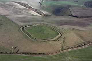
Uffington Castle is an early Iron Age univallate hillfort in Oxfordshire, England. It covers about 32,000 square metres and is surrounded by two earth banks separated by a ditch with an entrance in the western end. A second entrance in the eastern end was apparently blocked up a few centuries after it was built. The original defensive ditch was V-shaped with a small box rampart in front and a larger one behind it. Timber posts stood on the ramparts. Later the ditch was deepened and the extra material dumped on top of the ramparts to increase their size. A parapet wall of sarsen stones lined the top of the innermost rampart. It is very close to the Uffington White Horse on White Horse Hill.

Barbury Castle is a scheduled hillfort in Wiltshire, England. It is one of several such forts found along the ancient Ridgeway route. The site, which lies within the Wessex Downs Area of Outstanding Natural Beauty, has been managed as a country park by Swindon Borough Council since 1971. It is on Barbury Hill, a local vantage point, which, under ideal weather conditions, commands a view across to the Cotswolds and the River Severn. It has two deep defensive ditches and ramparts.
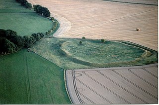
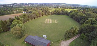
Liddington Castle, locally called Liddington Camp, is a late Bronze Age and early Iron Age univallate hillfort in Liddington parish in the English county of Wiltshire, and a scheduled monument.
Alfred's Castle is a small Iron Age hill fort, situated at grid reference SU277822, behind Ashdown Park in the civil parish of Ashbury in Oxfordshire. It lies 2–3 km south of the Ridgeway and is protected as a Scheduled Ancient Monument.

Blackbury Camp, also known as Blackbury Castle, is an Iron Age hill fort in Devon, England. It is managed by English Heritage.

Yarnbury Castle is the site of a multiphase, multivallate Iron Age hillfort near the village of Steeple Langford, Wiltshire, England. The site covers an area of 28.5 acres (11.5 ha), and was extensively surveyed and investigated by the Royal Commission on the Historical Monuments of England in 1991, with finds of Iron Age and Romano-British pottery, Iron Age and Roman coins, and burials of human remains. There is much evidence of prolonged and extensive settlement of the site, including evidence of around 130 structures of various sizes, most probably representing a mix of round houses, pits, and other features. It was designated as a scheduled monument in 1925.

Roundway Down and Covert is an area of sloping chalk grassland close to the hamlet of Roundway, near Devizes in Wiltshire, England. It is part of the North Wessex Downs Area of Outstanding Natural Beauty. At the summit of the slope are ancient earthworks, evidence of a Bronze Age human settlement and Iron Age hillfort.

Coney's Castle is an Iron Age hillfort in Dorset, England. The name Coney is from the Old English for rabbit, suggesting medieval use as a domestic warren, as at nearby Pilsdon Pen.
Vespasian's Camp is an Iron Age hillfort just west of the town of Amesbury, Wiltshire, England. The hillfort is less than 3 kilometres (2 mi) from the Neolithic and Bronze Age site of Stonehenge, and was built on a hill next to the Stonehenge Avenue; it has the River Avon on its southern side and the A303 road on its northern edge. The site is a scheduled monument and lies within the boundaries of the Stonehenge World Heritage Site.

The Trundle is an Iron Age hillfort on St Roche's Hill about 4 miles (6 km) north of Chichester, West Sussex, England, built on the site of a causewayed enclosure, a form of early Neolithic earthwork found in northwestern Europe. Causewayed enclosures were built in England from shortly before 3700 BC until at least 3500 BC; they are characterized by the full or partial enclosure of an area with ditches that are interrupted by gaps, or causeways. Their purpose is not known; they may have been settlements, meeting places, or ritual sites. Hillforts were built as early as 1000 BC, in the Late Bronze Age, and continued to be built through the Iron Age until shortly before the Roman occupation.
Letcombe Regis is a village and civil parish in the Vale of White Horse. It was part of Berkshire until the 1974 boundary changes transferred the Vale of White Horse to Oxfordshire. The village is on Letcombe Brook at the foot of the Berkshire Downs escarpment about 1 mile (1.6 km) southwest of the market town of Wantage. The 2011 Census recorded the parish population as 578.

Blewburton Hill is the site of an Iron Age hillfort located in Oxfordshire, in the southeast of England. It was a univallate hillfort. The area is mostly farmland with some small areas of wooded copse to the south and the northeast. The hill fort may have been occupied from the 4th century BC to the 1st century BC, and replaced a small settlement surrounded by a stockade, which is estimated to have been built in the 5th or 6th century BC.

Scratchbury Camp is the site of an Iron Age univallate hillfort on Scratchbury Hill, overlooking the Wylye valley about 1 km northeast of the village of Norton Bavant in Wiltshire, England. The fort covers an area of 37 acres (15 ha) and occupies the summit of the hill on the edge of Salisbury Plain, with its four-sided shape largely following the natural contours of the hill.

Bury Camp is the site of an Iron Age multivallate hillfort in north-west Wiltshire, England. It occupies a triangular promontory of Colerne Down, in the north of Colerne parish, at the southern edge of the Cotswold Hills between two spurs of a river valley. The enclosed area of approximately 9.2ha is surrounded by a ditch 4m wide and up to 1m deep, and an outer rampart up to 1.5m high on the east and northwestern sides and up to 2m high on the southwestern side, across the neck of the promontory.

Sidbury Hill, or Sidbury Camp, is the site of an Iron Age bivallate hillfort on the eastern edge of Salisbury Plain in Wiltshire, England. The site is sub-triangular in shape, approximately 17 acres (6.9 ha) in area, and is constructed on the site of a Neolithic settlement.
Hillforts in Britain refers to the various hillforts within the island of Great Britain. Although the earliest such constructs fitting this description come from the Neolithic British Isles, with a few also dating to later Bronze Age Britain, British hillforts were primarily constructed during the British Iron Age. Some of these were apparently abandoned in the southern areas that were a part of Roman Britain, although at the same time, those areas of northern Britain that remained free from Roman occupation saw an increase in their construction. Some hillforts were reused in the Early Middle Ages, and in some rarer cases, into the Later Medieval period as well. By the early modern period, these had essentially all been abandoned, with many being excavated by archaeologists in the nineteenth century onward.

Hollingbury Castle, also known as Hollingbury Camp and Hollingbury Hillfort, is an Iron Age hillfort on the northern edge of Brighton, in East Sussex, England. It is adjacent to Hollingbury Park Golf Course.
Dungeon Hill is an Iron Age hillfort, about 1+1⁄4 miles north of the village of Buckland Newton in Dorset, England. It is a scheduled monument.
South Weald Camp was a hillfort based in South Weald, Brentwood, Essex, England. Roughly circular in plan, the fort covered 2.8 hectares, with a suggested construction date in the late Iron Age, from the 1st century BC to the 1st century AD. The location is associated in this period with the Catuvellauni and the Trinovantes.

Maiden Bower is an Iron Age hillfort near Dunstable in Bedfordshire, England. The site, which also has traces of a Neolithic causewayed enclosure, is a scheduled monument.


