
KwaZulu-Natal is a province of South Africa that was created in 1994 when the Zulu bantustan of KwaZulu and Natal Province were merged. It is located in the southeast of the country, with a long shoreline on the Indian Ocean and sharing borders with three other provinces and the countries of Mozambique, Eswatini and Lesotho. Its capital is Pietermaritzburg, and its largest city is Durban. It is the second-most populous province in South Africa, with slightly fewer residents than Gauteng.

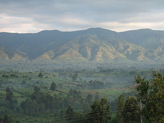
The Drakensberg is the eastern portion of the Great Escarpment, which encloses the central Southern African plateau. The Great Escarpment reaches its greatest elevation – 2,000 to 3,482 metres within the border region of South Africa and Lesotho.

A transboundary protected area (TBPA) is an ecological protected area that spans boundaries of more than one country or sub-national entity. Such areas are also known as transfrontier conservation areas (TFCAs) or peace parks.

Maloti-Drakensberg Park was established on 11 June 2001 by linking the Sehlabathebe National Park in the Kingdom of Lesotho and the uKhahlamba Drakensberg Park in KwaZulu-Natal, South Africa. The highest peak is Thaba Ntlenyana rising to 3.482 m.
Desert National Park is a national park situated in the Indian state of Rajasthan, near the towns of Jaisalmer and Barmer. This is one of the largest national parks, covering an area of 3162 km². The Desert National Park is an excellent example of the ecosystem of the Thar Desert. Sand dunes form around 44% of the Park. The major landform consists of craggy rocks and compact salt lake bottoms, intermedial areas and fixed dunes. The park was gazetted in 1980.

Simien Mountains National Park is the largest national park in Ethiopia. Located in the North Gondar Zone of the Amhara Region, its territory covers the highest parts of the Simien Mountains and includes Ras Dashan, the highest point in Ethiopia.
Rwenzori Mountains National Park is a Ugandan national park and UNESCO World Heritage Site located in the Rwenzori Mountains. Almost 1,000 km2 (386 sq mi) in size, the park has Africa's third highest mountain peak and many waterfalls, lakes, and glaciers. The park is known for its beautiful plant life.
The Central Balkan National Park lies in the heart of Bulgaria, nestled in the central and higher portions of the Balkan Mountains. Its altitude varies from 550 m. near the town of Karlovo to 2376 m. at Botev Peak, the highest summit in the mountain range. It was established on 31 October 1991. The Central Balkan National Park is the third largest protected territory in Bulgaria, spanning an area of 716.69 km² with total length of 85 km from the west to the east and an average width of 10 km. It occupies territory from 5 of the 28 provinces of the country: Lovech, Gabrovo, Sofia, Plovdiv and Stara Zagora. The national park includes nine nature reserves covering 28% of its territory: Boatin, Tsarichina, Kozya Stena, Steneto, Severen Dzhendem, Peeshti Skali, Sokolna, Dzhendema and Stara Reka.

The Maloti Mountains are a mountain range of the highlands of the Kingdom of Lesotho. They extend for about 100 km into the South African Free State. The Maloti Range is part of the Drakensberg system that includes ranges across large areas of South Africa. “Maloti” is also the plural for Loti, the currency of the Kingdom of Lesotho. The range forms the northern portion of the boundary between the Butha-Buthe District in Lesotho and South Africa's Free State.

Mount Sanqing is a renowned Taoist sacred mountain located 40 kilometres (25 mi) north of Yushan County in Jiangxi Province. Sanqing means the "Three Pure Ones" in Chinese as Mount Sanqing is made up of three main summits: Yujing, Yushui, and Yuhua, representing the Taoist trinity.

Golden Gate Highlands National Park is located in Free State, South Africa, near the Lesotho border. It covers an area of 340 km2 (130 sq mi). The park's most notable features are its golden, ochre, and orange-hued, deeply eroded sandstone cliffs and outcrops, especially the Brandwag rock. Another feature of the area is the numerous caves and shelters displaying San rock paintings. Wildlife featured at the park includes mongooses, eland, zebras, and over 100 bird species. It is the Free State's only national park, and is more famous for the beauty of its landscape than for its wildlife. Numerous paleontology finds have been made in the park, including dinosaur eggs and skeletons.

The wildlife of South Africa consists of the flora and fauna of this country in southern Africa. The country has a range of different habitat types and an ecologically rich and diverse wildlife, vascular plants being particularly abundant, many of them endemic to the country. There are few forested areas, much savanna grassland, semi-arid Karoo vegetation and the fynbos of the Cape Floristic Region. Famed for its national parks and big game, 297 species of mammal have been recorded in South Africa, as well as 849 species of bird and over 20,000 species of vascular plants.

Royal Natal National Park is a 80.94-square-kilometre (31.25 sq mi) park in KwaZulu-Natal province, South Africa and forms part of the uKhahlamba Drakensberg Park World Heritage Site. Notwithstanding the name, it is actually not a South African National Park managed by the SANParks, but rather a Provincial Park managed by Ezemvelo KZN Wildlife. This park is now included in the Maloti-Drakensberg Transfrontier Conservation Area Peace Park.

The uKhahlamba-Drakensberg Park is a protected area in the KwaZulu-Natal province of South Africa, covering 2,428.13 km2 (938 sq mi), and is part of a world heritage site. The park includes Royal Natal National Park, a provincial park, and covers part of the Drakensberg, an escarpment formation with the highest elevations in southern Africa.
The QwaQwa National Park is part of the Golden Gate Highlands National Park and the Maloti-Drakensberg Park and comprises the former Bantustan (homeland) of QwaQwa. It is approximately 60 km from Harrismith on the Golden Gate Road (R712) and formed an integral part of the Highlands Treasure Route.

Matatiele Local Municipality is a Category B municipality located in the Alfred Nzo District of Eastern Cape in South Africa. It adjoins Lesotho to the north, Elundini to the south-west, and Greater Kokstad to the east and its 4,352 km² makes the Matatiele Local Municipality largest of four municipalities in the district at almost half of its geographical area. [1]

Ts'ehlanyane National Park is a National Park in Lesotho. It is located in the Maloti Mountains in Leribe District, and is part of the larger Maloti-Drakensberg Transfrontier Conservation Area. This Lesotho northern park protects a high-altitude, 2,600-metre (8,500 ft) patch of rugged wilderness, including one of Lesotho’s only stands of indigenous forest with a number of rare undergrowth plants that are unique to this woodland habitat.
Aponogeton ranunculiflorus, the Sehlabathebe water lily, is a tiny and endangered species of aquatic plant, that belongs to the pondweed family Aponogetonaceae. It is protected in the Sehlabathebe National Park in the mountains of Lesotho, where it is very localized, and nearby in the uKhahlamba / Drakensberg Park of KwaZulu-Natal, South Africa. Outside these areas it is seriously threatened. It is found in sandstone rock pools, up to 7 metres deep, and in permanently wet tarns or sensitive high altitude mires, at altitudes between about 2,600 and 3,200 metres. Its spiralled stems allow the flowers to remain at surface level. Threats to the species include overgrazing and trampling by cattle, overburning, erosion and subsistence farming. Their small (1 cm) corms can survive the drying out of the pools, or being frozen into the muddy bottoms.
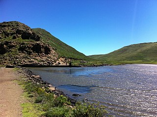
Lake Letsie is a reservoir in the Drakensberg mountains in Quthing District, Lesotho. The reservoir was formed when a smaller, natural lake was enlarged by damming the source of the Mohlakeng River in 1968. The lake and the wetlands surrounding the shore have been designated as a national protected area since 2001 and a Ramsar site since 2004.
