
The Mali Empire was an empire in West Africa from c. 1226 to 1670. The empire was founded by Sundiata Keita and became renowned for the wealth of its rulers, especially Mansa Musa. At its peak, Mali was the largest empire in West Africa, widely influencing the culture of the region through the spread of its language, laws, and customs.

French Sudan was a French colonial territory in the Federation of French West Africa from around 1880 until 1959, when it joined the Mali Federation, and then in 1960, when it became the independent state of Mali. The colony was formally called French Sudan from 1890 until 1899 and then again from 1921 until 1958, and had a variety of different names over the course of its existence. The colony was initially established largely as a military project led by French troops, but in the mid-1890s it came under civilian administration.

French West Africa was a federation of eight French colonial territories in West Africa: Mauritania, Senegal, French Sudan, French Guinea, Ivory Coast, Upper Volta, Dahomey and Niger. The federation existed from 1895 until 1958. Its capital was Saint-Louis in Senegal until 1902, and then Dakar until the federation's collapse in 1960.
The Senegambia is, in the narrow sense, a historical name for a geographical region in West Africa, named after the Senegal River in the north and the Gambia River in the south. However, there are also text sources which state that Senegambia is understood in a broader sense and equated with the term the Western region. This refers to the coastal areas between Senegal and Sierra Leone, where the inland border in the east was not further defined.

The Gambia River is a major river in West Africa, running 1,120 kilometres (700 mi) from the Fouta Djallon plateau in north Guinea westward through Senegal and The Gambia to the Atlantic Ocean at the city of Banjul. It is navigable for about half that length.
Upper Senegal and Niger was a colony in French West Africa, created on 21 October 1904 from colonial Senegambia and Niger by the decree "For the Reorganisation of the general government of French West Africa".
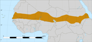
The Sahelian kingdoms were a series of centralized kingdoms or empires that were centered on the Sahel, the area of grasslands south of the Sahara, from the 8th century to the 19th. The wealth of the states came from controlling the trade routes across the desert. Their power came from having large pack animals like camels and horses that were fast enough to keep a large empire under central control and were also useful in such kind of battle. All of these empires were also quite decentralized with member cities having a great deal of autonomy.

French Sudan was established in the late nineteenth century and occupied roughly the same territory as modern Mali.

Senegambia and Niger was a short-lived administrative unit of the French possessions in Africa, formed in 1902 and reorganized in 1904 into Upper Senegal and Niger.
Upper Senegal and Niger was a colony in French West Africa created in 1904 from Senegambia and Niger. Niger became a separate military district in 1911 and a separate colony in 1922, Upper Volta was split off in 1919, and the remainder reorganized as French Sudan in 1920. The capital was Bamako.
The Mali Federation was a federation in West Africa linking the French colonies of Senegal and the Sudanese Republic for two months in 1960. It was founded on 4 April 1959 as a territory with self-rule within the French Community and became independent after negotiations with France on 20 June 1960. Two months later, on 19 August 1960, the Sudanese Republic leaders in the Mali Federation mobilized the army, and Senegal leaders in the federation retaliated by mobilizing the gendarmerie ; this resulted in a tense stand-off, and led to the withdrawal from the federation by Senegal the next day. The Sudanese Republic officials resisted this dissolution, cut off diplomatic relations with Senegal, and defiantly changed the name of their country to Mali. For the brief existence of the Mali Federation, the premier was Modibo Keïta, who would later become the first President of Mali, and its government was based in Dakar, the eventual capital of Senegal.

Azawad, or Azawagh, was a short-lived unrecognised state lasting between 2012 and 2013. Azawagh (Azawaɣ) is the generic Tuareg Berber name for all Tuareg Berber areas, especially the northern half of Mali and northern and western Niger. The Azawadi declaration of independence was declared unilaterally by the National Movement for the Liberation of Azawad (MNLA) in 2012, after a Tuareg rebellion drove the Malian Armed Forces from the region.

Bambouk is a traditional name for the territory in eastern Senegal and western Mali, encompassing the Bambouk Mountains on its eastern edge, the valley of the Faleme River and the hilly country to the east of the river valley. It was a formally described district in French Sudan, but in 1895, the border between French Sudan and Senegal was moved to the Faleme River, placing the western portion of the district within Senegal. The term is still used to designate the region, but there is no formal administrative area with that name.
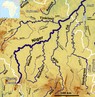
The Sankarani River is a tributary of the Niger River. Flowing northward from the Guinea Highlands of the Fouta Djallon in Guinea, it crosses into southern Mali, where it joins the Niger approximately 40 kilometres (25 mi) upstream of Bamako, the capital of Mali. It forms part of the Ivory Coast-Guinea and Guinea–Mali borders.
The Colony of Niger was a French colonial possession covering much of the territory of the modern West African state of Niger, as well as portions of Mali, Burkina Faso and Chad. It existed in various forms from 1900 to 1960 but was titled the Colonie du Niger only from 1922 to 1960.
The Jakhanke -- also spelled Jahanka, Jahanke, Jahanque, Jahonque, Diakkanke, Diakhanga, Diakhango, Dyakanke, Diakhanké, Diakanké, or Diakhankesare -- are a Manding-speaking ethnic group in the Senegambia region, often classified as a subgroup of the larger Soninke. The Jakhanke have historically constituted a specialized caste of professional Muslim clerics (ulema) and educators. They are centered on one larger group in Guinea, with smaller populations in the eastern region of The Gambia, Senegal, and in Mali near the Guinean border. Although generally considered a branch of the Soninke, their language is closer to Western Manding languages such as Mandinka.
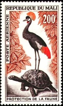
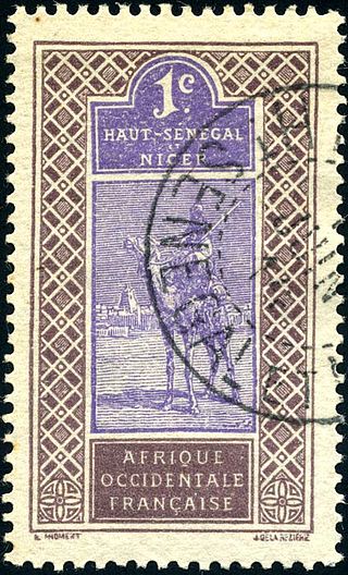
This is a survey of the postage stamps and postal history of Mali.
The following is a timeline of the history of the city of Bamako, Mali.
Senegambia is a region of West Africa, encompassing the modern states of Senegal, The Gambia, and Guinea-Bissau. Senegambia may also refer to:

Nigerien nationality law is regulated by the Constitution of Niger, as amended; the Nigerien Nationality Code, and its revisions; and various international agreements to which the country is a signatory. These laws determine who is, or is eligible to be, a national of Niger. The legal means to acquire nationality, formal legal membership in a nation, differ from the domestic relationship of rights and obligations between a national and the nation, known as citizenship. Nationality describes the relationship of an individual to the state under international law, whereas citizenship is the domestic relationship of an individual within the nation. Nigerien nationality is typically obtained under the jus sanguinis, i.e. by birth in Niger or abroad to parents with Nigerien nationality. It can be granted to persons with an affiliation to the country, or to a permanent resident who has lived in the country for a given period of time through naturalization.

