
Sengar River is a tributary of the river Yamuna in the northern Indian state of Uttar Pradesh.
Sengar River is a tributary of the river Yamuna in the northern Indian state of Uttar Pradesh.
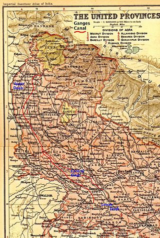
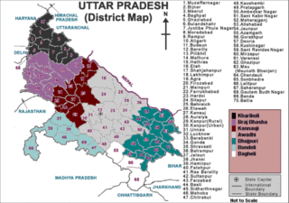
Sengar originates near Adhawan lake in Aligarh district and drains [Hathras District ]Etawah, Mainpuri and Kanpur districts before it confluences with the Yamuna between Kalpi and Hamirpur. It has a total length of 304 km (190 miles). [1] The Sengar flows parallel to the Yamuna in Etawah district and is joined by the Sirsa river near Amritpur. It forms a doab with the Rind in Kanpur district. Much of the Sengar's basin in Etawah and Kanpur districts is under red loamy soil. [2] [3] The 1878 settlement report for Kanpur district also notes that the river is fringed by a series of ravines that had impacted adversely the fertility of the soil in the river's vicinity. [3]
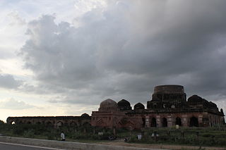
Sengar - originally called Basind - is said to have been named after the Sengar Rajputs after they captured most of Etawah following the fall of Kannauj in the medieval period. [4]
Rapid urbanisation and industrialisation and the discharge of domestic and industrial effluents into the river has caused severe pollution in the river. [5]

The Yamuna is the second-largest tributary river of the Ganges by discharge and the longest tributary in India. Originating from the Yamunotri Glacier at a height of about 4,500 m (14,800 ft) on the southwestern slopes of Bandarpunch peaks of the Lower Himalaya in Uttarakhand, it travels a total length of 1,376 kilometres (855 mi) and has a drainage system of 366,223 square kilometres (141,399 sq mi), 40.2% of the entire Ganges Basin. It merges with the Ganges at Triveni Sangam, Allahabad, which is a site of the Kumbh Mela, a Hindu festival held every 12 years.

Etawah also known as Ishtikapuri is a city on the banks of Yamuna River in the state of Western Uttar Pradesh in India. It is the administrative headquarters of Etawah District. Etawah's population of 256,838 makes it the one hundred and eightieth-most populous city in India. The city lies 300 km (190 mi) southeast of the national capital New Delhi, and 230 km (140 mi) northwest of the state capital Lucknow.

Doab is a term used in South Asia for the tract of land lying between two confluent rivers. It is similar to an interfluve. In the Oxford Hindi-English Dictionary, R. S. McGregor defines it as from Persian do-āb "a region lying between and reaching to the confluence of two rivers.
Mainpuri is a city in Mainpuri district in the Indian state of Uttar Pradesh. It is the administrative headquarters of Mainpuri district and is situated to the north-east of Agra and is 270 km from New Delhi. Mainpuri forms part of the ancient legendary region of Lord Krishna's land called Braj.
Kalpi is a historical city and municipal board in Jalaun district in Uttar Pradesh, India. It is on the right bank of the Yamuna. Once Kalpi was more important Than Orai It is situated 78 kilometres south-west of Kanpur from which it is connected by both road and rail.

Firozabad is a city near Agra in Firozabad district in the state of Uttar Pradesh in India. It is the centre of India's glassmaking industry and is known for the quality of the bangles and also glasswares produced there.

Jalaun district is a district of Uttar Pradesh, India. The district is named after the town of Jalaun, which was the former headquarters of a Maratha governor, but the administrative headquarters of the district is at Orai. Other major towns in the district are Konch, Kalpi, and Madhogarh.
Mainpuri district is one of the districts in the Agra division of Uttar Pradesh, India. Mainpuri town is the district headquarters. It consists of six tehsils, namely Mainpuri, Bhongaon, Karhal, Kishni, Kurawali and Ghiror.

Kanpur division is an administrative geographical unit of Uttar Pradesh state of India. Kanpur is the administrative headquarters of the division. Kanpur was formerly spelled Cawnpore. The division consists of six districts:
The Ganges Canal or Ganga Canal is a canal system that irrigates the Doab region between the Ganges River and the Yamuna River in India.

Farrukhabad district is a district of Uttar Pradesh state in Northern India. The town of Fatehgarh is the district headquarters. The district is part of Kanpur Division.
Pahuj River is a river flowing through the city of Jhansi, Uttar Pradesh, India. It has been referred as the Pushpavati in religious texts. It is a small and dry river which passes through the Indian Grassland and Fodder Research Institute, Jhansi. It flows through the region of Bundelkhand region and a plays a major part in dividing the border of Uttar Pradesh and Madhya Pradesh. Generally it flows at a heavy water level outside its banks in the monsoon season but drastically can also go dry or with very little flow in the summers. Nowadays many electric plants in Uttar pradesh are discharging its waste in it due to which the water of the river getting contaminated day by day and also illegal mining at the banks of it is causing its state deteriorating day by day. The river is approx 195 km from its origin to mouth.
Auraiya is a city and a municipal board in Auraiya district in the state of Uttar Pradesh, India. NH 19 passes through the center of the town. Phaphund railway station is nearest Railway Station. Saifai Airstrip is the nearest aviation facility, having limited private use. Nearest commercial airport is the Kanpur Airport.Before becoming the district headquarters, it was the tehsil headquarters of Etawah district. This district is under Kanpur Mandal. [1] [2] [3] This is the heroic place of Sengar Rajputs. Sengar dynasty Kanardhani Maharajadhiraj Vishok Dev was married to Devkala, sister of Maharaja Jaichand Gaharwar (Rathore) of Kannauj. He had received this entire area in dowry. The famous Devkali temple here was also built by him in the name of his wife Devkali. There are many famous villages of Kshatriya in which Ayana, Bhartaul, Jaswantpur, Bhurepur Kalan, Bhurepur Khurd, Sikharna, Fareha, Anepur, Senganpur, Barbatpur, Roshangpur, Manpur, Phaphund, Aseva are very famous villages.
Shikohabad is a city and a municipal board in the Firozabad district of the Indian state of Uttar Pradesh.
Sengar, also known as Sanghar, Singraur or Songar, are a clan of Rajputs in India.

Auraiya district is one of the districts of Uttar Pradesh state of India, and Auraiya town is the district headquarters. It lies on the south-western portion of Uttar Pradesh and also forms a part of the Kanpur Division.
Bhareh is a town in Etawah district in the state of Uttar Pradesh, India. This is situated on the confluence of Yamuna and Chambal rivers. There is an old fort belonging to the Sengar clan.This is the heroic place of Sengar Rajputs. Sengar dynasty Kanardhani Maharajadhiraj Vishok Dev was married to Devkala, sister of Maharaja Jaichand Gaharwar (Rathore) of Kannauj. The last Raja of Bhareh was Raja Niranjan Singh Judeo who was also a Freedom Fighter. He was also an avid flyer and one of the few at that time to have obtained a flying licence. He died in 1991. His eldest son was late Amar Singhji who died in 2004.Singh. Amar Singhji's brother is Krishna Chandra Singh Sengar, who has now settled in Noida, and lives with his spouse, Malti Sengar. Krishna Sengar has 2 children, Ashvini Sengar and Malvika Sengar. Ashvini Sengar has 3 children: Anjali Sengar, Aniket Sengar and Anugrah Sengar. Malvika Katoch, has 2 children: Aditya Katoch and Niharika Katoch.
Western Uttar Pradesh is a region in India that comprises the western districts of Uttar Pradesh state, including the areas of Rohilkhand and those where Khariboli, Braj and Kannauji are spoken. The region has some demographic, economic and cultural patterns that are distinct from other parts of Uttar Pradesh, and more closely resemble those of Haryana and Rajasthan states. Western Uttar Pradesh has experienced rapid economic growth, in a fashion similar to Haryana and Punjab, due to the successes of the Green Revolution. A significant part of western Uttar Pradesh is a part of National Capital Region of India. The largest city of the region is Ghaziabad, while the second-largest city, Agra, is a major tourist destination.
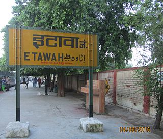
Etawah Junction railway station is one of the main railway stations on the Kanpur–Delhi section of Howrah–Delhi main line. It is 139 km (86 mi) away from Kanpur Central.Tundla is 92 km (57 mi) from here, from where lines to Agra bifurcates. It is located in Etawah district in the Indian state of Uttar Pradesh. It serves Etawah and the surrounding areas. Etawah stands near the confluence of the Yamuna and the Chambal.
Bhadauria also called Bhadoria, Bhadouria, Bhadauriya, Bhadoriya or Bhaduria are Rajputs of Chauhan clan. They were historically mainly concentrated in what are now the districts of Agra, Etawah, Bhind and Dholpur, which includes the states of Uttar Pradesh, Madhya Pradesh, and Rajasthan.
sengar river.