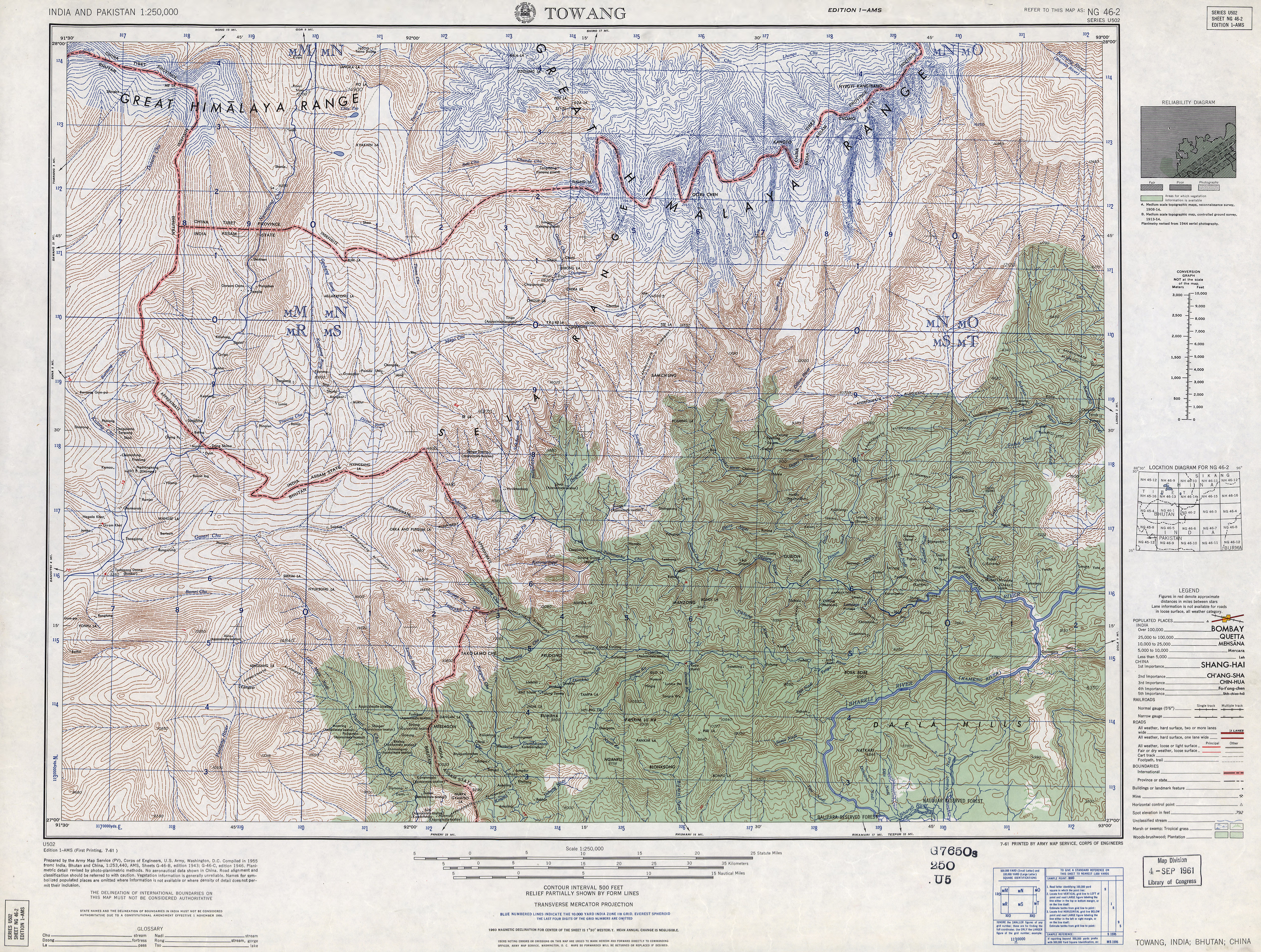
Geography and climate
Sessa and Eaglenest together occupy a rough east–west rectangle with Sessa occupying the north-east quadrant. The Bhalukpong-Bomdila highway (and Pakke immediately beyond) are its eastern boundary. It is bounded to the north by the Tenga River valley. [1] Altitude is 900 metres (2,953 ft) to 3,250 metres (10,663 ft).
Sessa and Eaglenest ridges rise to 3,250 metres (10,663 ft) and 2,700 metres (8,858 ft) respectively and are the first major barriers to the monsoon as it moves north from the plains of Assam. These ridges get over 3,000 millimetres (120 in) of rain on the southern slopes and about 1,500 millimetres (59 in) on the northern slopes. [2]
Sessa sanctuary is drained by the Tippi Naala (Tippi river), which joins the Kameng river at Tippi village on the Bhalukpong-Bomdila highway. [3]
Sessa is part of the Kameng protected area complex (KPAC), the largest contiguous closed-canopy forest tract of Arunachal Pradesh, which includes Sessa, Eaglenest, Pakke, Nameri, and Sonai Rupai sanctuaries and associated reserved forest blocks. The Complex covers 3500 km2 in area and ranges from 100 metres (328 ft) to 3,300 metres (10,827 ft)3300m in altitude. [4]

West Kameng is a district of Arunachal Pradesh in northeastern India. It accounts for 8.86% of the total area of the state. The name is derived from the Kameng river, a tributary of the Brahmaputra, that flows through the district.

The Nyishi community is the largest ethnic group in Arunachal Pradesh in north-eastern India. The Nyishi language belongs to the Sino-Tibetan family, however, the origin is disputed. Their population of around 300,000 makes them the most populous tribe of Arunachal Pradesh, closely followed by the tribes of the Adi according to 2001 census.

Bomdila is the headquarters of West Kameng district in the state of Arunachal Pradesh in India. Bomdila is one of the 60 constituencies of the state of Arunachal Pradesh.

Nameri National Park is a national park in the foothills of the eastern Himalayas in the Sonitpur District of Assam, India, about 35 km from Tezpur. Nameri is about 9 km from Chariduar, the nearest village.

Japalura austeniana, also known commonly as the Abor Hills agama or Annandale's dragon, is a rare species of lizard in the family Agamidae. The species is endemic to Asia.
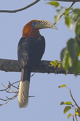
The rufous-necked hornbill is a species of hornbill in Bhutan, northeastern India, especially in Arunachal Pradesh, Indian Subcontinent and Southeast Asia. It is locally extinct in Nepal due to hunting and significant loss of habitat. There are less than 10,000 adults left in the wild. With a length of about 117 cm (46 in), it is among the largest Bucerotine hornbills. The underparts, neck and head are rich rufous in the male, but black in the female.

Bhalukpung is a small town located along the southern reaches of the Himalayas in West Kameng district of Arunachal Pradesh in India. The town is located at 213m above sea level, 100 km from Bomdila, 52 km from Tezpur and 5 km from Tipi. It lies along the Kameng river and is the headquarters of Bhalukpung circle. A road leads to Bomdila via the Tipi Orchidariurm, and the inner line check post is located at Bhalukpung. It has a railway station namely Bhalukpong Railway Station, connected to Rangiya Murkongselek rail line at Balipara. It has 3 platforms. One pair of trains runs daily to and from here.

The Bugun liocichla is a passerine bird species from the family Leiothrichidae closely related to the Emei Shan liocichla. First spotted in 1995 in Arunachal Pradesh, India, it was described as a new species in 2006. The description was made without the collection of a type specimen as they were too few to risk killing one. It is thought to be an endangered species, with a small population, and a very restricted distribution range within which commercial development threatens the habitat.

Eaglenest or Eagle's Nest Wildlife Sanctuary is a protected area of India in the Himalayan foothills of West Kameng District, Arunachal Pradesh. It conjoins Sessa Orchid Sanctuary to the northeast and Pakhui Tiger Reserve across the Kameng river to the east. Altitude ranges are extreme: from 500 metres (1,640 ft) to 3,250 metres (10,663 ft). It is a part of the Kameng Elephant Reserve.

The black-backed forktail, occasionally referred to as the black-throated forktail, is a forktail species in the family Muscicapidae. The species was described in 1836, from a specimen collected in Nepal. It is a medium-sized forktail, weighing between 25 and 29 grams, with a length of 20.5 to 23 centimetres. The species has a broad white stripe across its forehead. The crown, face, and mantle are black, while the bird's underparts are white, sharply divided from the black above. The wings are largely black with a broad white stripe across the greater coverts. The tail of the species, similar to that of other forktails, is long, graduated, and deeply forked. The tail is black with a white tip and three white bands created by shorter tail feathers. The beak of the bird is black, while the feet and legs are light pink, and the iris is brown. The species is monomorphic.
The Kameng Elephant Reserve is an Elephant Reserve located in the Himalayan foothills of Arunachal Pradesh, India, in the districts of West Kameng and East Kameng.
Pakke Tiger Reserve, is a Project Tiger reserve in the East Kameng district of Arunachal Pradesh in Northeast India. The 862 km2 (333 sq mi) reserve is protected by the Department of Environment and Forest of Arunachal Pradesh. It was known as Pakhui Tiger Reserve, but renamed in April 2001 by the Governor of Arunachal Pradesh. It has won India Biodiversity Award 2016 in the category of 'Conservation of threatened species' for its Hornbill Nest Adoption Programme.
The Trans-Arunachal Highway (TAH), which includes an existing 1,811 km (1,125 mi) route comprising NH-13 and parts of NH-15, NH-215 and SH-25, is an under-construction 2-lane more than 2,407 km (1,496 mi) long highway passing through 16 districts in Arunachal Pradesh state in India. It runs from LAC in Tawang in northwest to Kanubari in southeast at tri-junction of Assam-Nagaland-Arunachal Pradesh. It connects at least 16 districts of Arunachal Pradesh.

The Department of Environment and Forests of Arunachal Pradesh (DEFAP) is a state-sponsored agency responsible for conserving the environment, identifying, establishing, and conserving protected areas in the Indian state of Arunachal Pradesh.
Arunachal Frontier Highway (AFH), officially notified as the National Highway NH-913 and also called Bomdila-Vijaynagar Highway (BVH), connecting Bomdila Airstrip ALG & HQ in northwest to Vijaynagar Airstrip ALG & HQ in southeast via Nafra HQ-Sarli HQ-Huri Helipad ALG & HQ-Nacho HQ-Mechuka Airstrip ALG & HQ-Monigong HQ-Jido -Hunli HQ-Hayuliang Airstrip ALG HQ-Chenquenty-Hawai HQ-Miao HQ including 800 km greenfield section and network of new tunnels & bridges, is a 2-lane paved-shoulder under-construction national highway along the India-China LAC-McMahon Line border in the Indian state of Arunachal Pradesh. The 1,748 km-long (1,086 mi) highway itself will cost ₹27,000 crore and total cost including 6 additional inter-corridors is ₹40,000 crore. In some places, this highway will run as close as 20 km from the LAC. To be constructed by MoRTH in 9 packages, all packages will be approved by the end of fy 2024-25 and construction will be completed in 2 years by 31 March 2027. Of the total route, 800km is greenfield, rest brownfield will be upgraded and tunnels will be built. This highway in the north & east Arunachal along the China border, would complement the Trans-Arunachal Highway and the Arunachal East-West Corridor as major highways spanning the whole state, pursuing the Look East connectivity policy.

Arunachal Pradesh is primarily a hilly tract nestled in the foothills of the Himalayas in northeast India. It is spread over an area of 83,743 km2 (32,333 sq mi). 98% of the geographical area is land out of which 80% is forest cover; 2% is water. River systems in the region, including those from the higher Himalayas and Patkoi and Arakan Ranges, eventually drain into the Brahmaputra River.

The following outline is provided as an overview of and topical guide to Arunachal Pradesh:
Pakke Kessang is a town in the Indian state of Arunachal Pradesh. It is located in Pakke-Kessang district, which has been carved out of the East Kameng district along with five administrative units, namely Pakke Kessang, Seijosa, Pijerang, Passa Valley, and Dissing-Passo with district headquarters at Lemmi.

Pakke-Kessang is a district located in the state of Arunachal Pradesh in the Northeast of India. The district used to be a part of the neighboring district, East Kameng, and was created out of its five southernmost administrative units: Pijerang, Passa Valley, Pakke-Kessang, Dissing Passo and Seijosa. The district headquarters of Pakke-Kessang is located at Lemmi (near Boundary of Papum pare


