
Haida Gwaii, also known as the Queen Charlotte Islands, is an archipelago located between 55–125 km (34–78 mi) off the northern Pacific coast of Canada. The islands are separated from the mainland to the east by the shallow Hecate Strait. Queen Charlotte Sound lies to the south, with Vancouver Island beyond. To the north, the disputed Dixon Entrance separates Haida Gwaii from the Alexander Archipelago in the U.S. state of Alaska.

Graham Island is the largest island in the Haida Gwaii archipelago, lying off the mainland coast of British Columbia, Canada. It is separated by the narrow Skidegate Channel from the other principal island of the group to the south, Moresby Island. It has a population of 3,858, an area of 6,361 km2 (2,456 sq mi), and is the 101st largest island in the world and Canada's 22nd largest island.

The Dixon Entrance is a strait about 80 kilometers (50 mi) long and wide in the Pacific Ocean at the Canada–United States border, between the U.S. state of Alaska and the province of British Columbia in Canada. The Dixon Entrance is part of the Inside Passage shipping route. It forms part of the maritime boundary between the U.S. and Canada, although the location of that boundary here is disputed.

Hecate Strait is a wide but shallow strait between Haida Gwaii and the mainland of British Columbia, Canada. It merges with Queen Charlotte Sound to the south and Dixon Entrance to the north. About 140 kilometres (87 mi) wide at its southern end, Hecate Strait narrows in the north to about 48 kilometres (30 mi). It is about 260 kilometres (160 mi) in length.
The North Coast Regional District is a quasi-municipal administrative area in British Columbia. It is located on British Columbia's west coast and includes Haida Gwaii, the largest of which are Graham Island and Moresby Island. Its administrative offices are in the City of Prince Rupert.

Masset is a village in the Haida Gwaii archipelago in British Columbia, Canada. It is located on Masset Sound on the northern coast of Graham Island, the largest island in the archipelago, and is approximately 50 km (31 mi) west of mainland British Columbia. It is the primary western terminus of Trans-Canada Highway 16 and is served by Masset Airport, with flights to Vancouver and Prince Rupert. During the maritime fur trade of the early 19th century, Masset was a key trading site. It was incorporated as a village municipality on May 11, 1961.
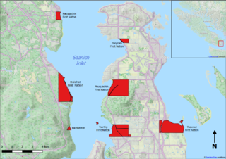
Bamberton is an industrial site located on the Saanich Inlet, just south of Mill Bay, around 45 kilometres north of Victoria on Vancouver Island.
Port Clements is an incorporated village situated at the east end of Masset Inlet in Haida Gwaii off the coast of the Province of British Columbia in Canada. Known as Gamadiis in HlG̱aagilda X̱aayda kil, it is one of seven village sites that flourished in the rich waters at the mouth of Yakoun River, where an estuary shelters nine Pacific salmonid species and many kinds of birds. Founded by Eli Tingley in 1907, it was once known under the name Queenstown, but renamed to Port Clements in 1914 after Herb S. Clements, the local MP at the time, when the name "Queenstown" duplicated and therefore became unusable for the post office.
Juskatla is a settlement on Juus Ḵáahlii, a sidewater off the southern end of Masset Inlet on Graham Island, the largest and northernmost of the Haida Gwaii islands off the North Coast of British Columbia, Canada.
The Queen Charlottes Gold Rush was a gold rush in southern Haida Gwaii of what is now the North Coast of British Columbia, Canada, in 1851.

Masset Inlet is a large saltwater bay located in the heart of the lowland of northern Graham Island, the northernmost and largest island of the Haida Gwaii islands on the North Coast of British Columbia, Canada. It is fed by several rivers, the largest of which is the Yakoun River, and is connected to the open sea of the Dixon Entrance by the narrow Masset Sound and Masset Harbour, which opens onto McIntyre Bay. The communities of Port Clements and Sewall are located on the shores of Masset Inlet. The community of Juskatla is located on Juus Ḵáahlii, the largest of Masset Inlet's arms. There are several islands in the inlet, the largest of which is Kumdis Island, at the inlet's egress to Masset Sound and just north of Port Clements. Masset Inlet helps form the isthmus of the Naikoon Peninsula.

Masset Sound is a 38-kilometre (24 mi) saltwater inlet on Graham Island, the largest and northernmost of the Haida Gwaii islands of the North Coast of British Columbia, Canada, connecting Masset Inlet in the island's interior with the open sea via Masset Harbour and McIntyre Bay to the Dixon Entrance. It averages 1.5 kilometres (0.93 mi) in width and is less than 750 metres (2,460 ft) width in certain spots. The town of Masset is located on the east bank of Masset Sound's northern end.
The 2012 Haida Gwaii earthquake occurred just after . The shock had a moment magnitude of 7.8 and a maximum Mercalli Intensity of V (Moderate). The earthquake's epicentre was on Moresby Island of the Haida Gwaii archipelago. This was the second largest Canadian earthquake ever recorded by a seismometer, after the 1949 Queen Charlotte Islands earthquake, about 135 kilometres (84 mi) away. One person died due to a car crash related to the tsunami in Oahu, Hawaii.

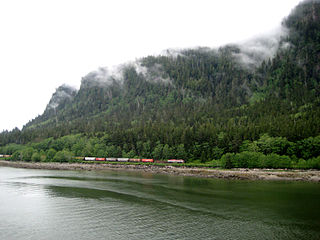
Camosun was a steamship built in 1904 in Paisley, Scotland, which served in British Columbia.

Old Massett, named G̱aw in X̱aad kíl, is an Indigenous Canadian village on Graham Island in Haida Gwaii, British Columbia. It lies on the east side of Masset Sound close to the town of Masset; the area of land it is on is legally designated Masset Indian Reserve No. 1, or Masset 1. The original name of the settlement was Uttewas, meaning "white-slope village" in the Haida language. It is populated by Haida people of both Ḵuustak, the Eagle matrilineage, and Ḵayx̱al, the Raven matrilineage. The town is administered by the Old Massett Village Council. Its population has fluctuated over the last one hundred and fifty years; smallpox, especially the 1862 Pacific Northwest smallpox epidemic, drastically reduced its numbers in the late 1800s, but in 1968, it had over 1,000 people and was the largest village in Haida Gwaii. In 2009, the Village Council counted 2,698 band members in the area; the 2016 census counted 555 living at the Old Massett townsite.
Jedway is a landing and erstwhile settlement and mining camp on Harriet Harbour, part of Skincuttle Inlet, on the east coast of Moresby Island in Haida Gwaii, British Columbia, Canada. Jedway was once a hub for mines in the area during a mining boom on South Moresby, including mines at Ikeda and Lockeport, though a mine at the Jedway iron-magnetite deposit, known as the Jessie showings, did not open until 1961. In the earlier period, Jedway was the de facto capital of the archipelago, as it was the headquarters of the provincial Gold Commissioner, E. M. Sandilands, whose position carried with it all the functions of and powers of government. It lost this status when he relocated to Queen Charlotte City in 1910. A 1908 in The Ledge, a mining newspaper based in Greenwood, said "there is room for another hotel in Jedway". Jedway remained a local service centre after that, but the relocation of two Chinese men sentenced to months-long imprisonment to Jedway from Queen Charlotte City in 1912 suggests the presence of jail facilities there.
Delkatla is a community on the east side of the mouth of Masset Inlet on Graham Island in the Haida Gwaii archipelago in British Columbia, Canada.
Kiusta located on Haida Gwaii is the oldest Northern Haida village: and the site of first recorded contact between the Haida and Europeans in 1774. Haida lived in this village for thousands of years, due to the sheltered nature of its location it was used for boats offloading, especially in rough waters. Kiusta is one of the oldest archeological sites of human use in British Columbia, and continues to be a site for cultural revitalisation.

Various Imperial and colonial actions against Haida Gwaii Authorities have been undertaken since the 19th century. The indigenous peoples of Haida Gwaii often reacted violently to European and American ships which trespassed in their waters and lands. From the 18th to 19th centuries, various skirmishes took place between Haida authorities and European and American merchantmen and warships. Canadian settlers did not arrive on Haida Gwaii islands until 1900, and many Canadian colonial police actions attempted to assault the Haida Gwaii authorities and citizens. The indigenous Haida population was decimated by diseases such as smallpox which were introduced accidentally by way of Fort Victoria. The presence of foreign diseases, to which the Haida had no immunity, along with some colonial hostility, meant that the numbers of Haida citizens was reduced from tens of thousands to 588 by 1915. This erosion of Haida cultural institutions was essential to open the way for subsequent British and Canadian incursions and jurisdictional claims.
