Sewards End

Last updated

Sewards End
Village
St. James' church, Sewards End, Essex - geograph.org.uk - 223502.jpg
St. James' church, Sewards End, Essex
Coordinates: 52°1′12″N0°17′13″E / 52.02000°N 0.28694°E / 52.02000; 0.28694
District Uttlesford
County Essex
Country England
Government
  Type Civil parish (from 2004)
Population
531

Sewards End is a village and civil parish in the Uttlesford district of Essex, England. Its area is 1211 acres. It is set in the rolling countryside of north west Essex. The village's village hall is two miles east of the centre of Saffron Walden and one and a third miles from Tesco's store. The population was 511 in 2011 with 124 children under the age of 18 and 87 people aged over 64. The median age was 47. There are about 210 houses in the village (2020). There are 23 listed buildings. The village became a civil parish on 1 April 2004. [1]

Contents

Location

Sewards End is in the county of Essex, in south eastern England, 43 miles from London, 17 miles from Cambridge, 14 miles from Bishops Stortford and one mile from Saffron Walden. [2]

History

In the 11th century Sewards End did not exist as a defined community. At that time there were four smaller communities around what would eventually become Sewards End. [ citation needed ]

Probably the most influential at that time was Wills Ayley where Monks from Saffron Walden had been granted 60 acres of land in 1070. In 1090 Geoffrey de Mandeville, Lord of Saffron Walden, granted 60 acres of land to Sigesward reputedly his food taster. Ten years after his death in Belgium in 1114, his grandson, Albold de Pouncyn applied to have the land reinstated to him. Albold named the village in memory of his grandfather. [ citation needed ]

The monks of Wills Ayley acquired St Aylotts by 1248. Everyone had to serve the Monks and over the next 200 years they took over the village. [ citation needed ]

In the mid 14th century the Black Death reached Sewards end and the population of the village reduced from 400 to 100. [ citation needed ]

By the 15th century the monastery applied for and was granted the position of land recorders and they grabbed the titles of every available land holding. [ citation needed ]

Very early in the 16th century the village was amalgamated under the name of Sewers End. [ citation needed ]

However, the monks continued to dominate. Rents were high and men, women and children had to work 7 days a week in order to pay rent. Seeking wood for fuel or catching rabbits for food led to flogging or hanging. The citizens of Sewards End were virtual prisoners within the confines of the village as they had to pay at the toll gates set up around every exit and entry to the village. [ citation needed ]

In 1531 things were to change. Henry the VIII was on the throne and he severed links with Rome. The Act of Reformation outlawed the Monasteries. The people of Sewards End joined in with what was happening elsewhere. Monks were captured and hung or forced to flee and Monasteries were sacked. This is why there is no trace of the Monastery at Wills Ayley. [ citation needed ]

The community's name has changed over the centuries from Syward-hes-haund in 1286, Sewardsende in the mid 14th century and eventually to the name close to the one used today, Sewers End a name that continued until as late as 1911. [ citation needed ]

As Sewards End dates back many centuries, it is fortunate to include many examples of fine historic architecture, including buildings such as "Everards" and the folly known as "The Towers". [ citation needed ]

In 2014 the Tour de France cycle race passed through the village watched by many people including a significant number of non- villagers. [ citation needed ]

Church and School.

The village's church, St James', is a chapel of ease of St Mary's Church, Saffron Walden. It was built in 1847 and substantially enlarged in 1870. The church building was also used as a school from 1847 to 1947. In May 1885 the average school attendance was 90 pupils. [ citation needed ]

Recent Change

In common with many other rural villages of its size, Sewards End has seen many changes in recent decades. There was a working mill until 1914 but it was demolished soon after. The 2nd half of the 20th century saw the village moving away from its rural roots where a high percentage of the population either worked on the land or in local industry, to the role of dormitory village, the population frequently commuting to Cambridge or further afield to London via road and rail links. [ citation needed ]

These changes have inevitably led to alterations in the social fabric of the community and they are evidenced by the closure of the village's two pubs (The Fox and the Green Dragon), its local shop, post office and garage as well as the downsizing of its once vibrant cricket club during the last 3 decades of the 20th century. After many years without a home, Sewards End Cricket Club has survived by playing Sunday social cricket over the years and continues to do so with the aim of playing regularly back in the village once again. [ citation needed ]

Villagers' lifestyles have moved on and so have their social and economic ambitions. The positive aspects of those changes were consolidated when local residents Alice Olley and Seamus McNally campaigned to have the village identity recognized, culminating in the creation of a new civil parish, Alice going on to be the first ever chair of Sewards End Parish Council. parish council. [ citation needed ]

Village life is also enhanced through the successful and active village hall and thriving parish church, St James. [ citation needed ]

Conservation

The increasing affluence of the area has also seen several examples of sympathetic restoration to local properties such as "Campions", "Satis House", "Wheel Hall Cottage" and more recently "Sewards End Farmhouse". [ citation needed ]

See also

The Hundred Parishes

Related Research Articles

<span class="mw-page-title-main">Saffron Walden</span> Town in Essex, England

Saffron Walden is a market town in the Uttlesford district of Essex, England, 12 miles (19 km) north of Bishop's Stortford, 15 miles (24 km) south of Cambridge and 43 miles (69 km) north of London. It retains a rural appearance and some buildings of the medieval period. The population was 15,504 at the 2011 census.

<span class="mw-page-title-main">Ugley</span> Human settlement in England

Ugley is a small village and civil parish in the non-metropolitan district of Uttlesford in Essex, England. It is about 2 miles (3 km) north from Stansted Mountfitchet, and situated between Saffron Walden and Bishop's Stortford. Within the parish is the village of Ugley Green, 1.5 miles (2.4 km) to the south.

<span class="mw-page-title-main">Clavering, Essex</span> Human settlement in England

Clavering is a village and also a parish in north-west Essex in England. It is about 20 miles (32 km) from Cambridge and 50 miles (80 km) from Southend-on-Sea. The name 'Clavering' means 'place where clover grows'.

<span class="mw-page-title-main">Saffron Walden (UK Parliament constituency)</span> Parliamentary constituency in the United Kingdom

Saffron Walden is a constituency in Essex represented in the House of Commons of the UK Parliament since 2017 by Kemi Badenoch, a Conservative.

<span class="mw-page-title-main">Arkesden</span> Human settlement in England

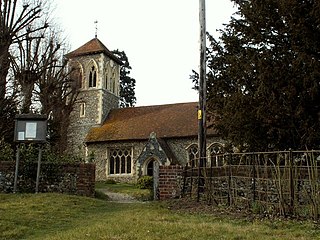
Arkesden is a village and civil parish in the Uttlesford district of Essex, England.

<span class="mw-page-title-main">Ashdon</span> Human settlement in England

Ashdon, is a village and civil parish in Essex, England. It is about 4 miles (6 km) northeast of Saffron Walden and 23 miles (37 km) northwest from the county town of Chelmsford. The village is in the district of Uttlesford and the parliamentary constituency of Saffron Walden. The village has its own Parish Council.

<span class="mw-page-title-main">Aythorpe Roding</span> Human settlement in England

Aythorpe Roding is a village and civil parish in the Uttlesford district of Essex, England. The village is included in the eight hamlets and villages called The Rodings. Aythorpe Roding is 9 miles (14 km) northwest from the county town of Chelmsford.

<span class="mw-page-title-main">Broxted</span> Human settlement in England

Broxted is a village and civil parish in the Uttlesford district, in the county of Essex, England. It is situated 11 km (6.8 mi) north-east from Bishop's Stortford, Hertfordshire and 23 km (14 mi) north-west from the county town of Chelmsford.

<span class="mw-page-title-main">Henham</span> Human settlement in England

Henham, or Henham-on-the-Hill is a village and civil parish in the Uttlesford district of Essex, England. The village is situated 2.5 miles (4 km) north from London Stansted Airport. The parish includes the hamlets of Little Henham and Pledgdon Green. Parish population at the 2011 Census was 1,233.

<span class="mw-page-title-main">Newport, Essex</span> Human settlement in England

Newport is a large village and civil parish in the Uttlesford district in Essex, near Saffron Walden. The village has a population of over 2,000, measured at 2,352 at the 2011 census.

<span class="mw-page-title-main">Langley, Essex</span> Human settlement in England

For the historic house in Essex called Langley's, see Great Waltham.

<span class="mw-page-title-main">Wendens Ambo</span> Human settlement in England

Wendens Ambo is a village in the Uttlesford district of Essex, England. The population at the 2011 census was measured at 473. Its name originates from the merging of two originally separate villages called Wenden Magna and Wenden Parva, ambo being the Latin for "both".

<span class="mw-page-title-main">Wicken Bonhunt</span> Human settlement in England

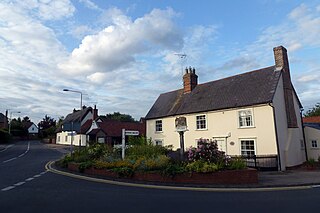
Wicken Bonhunt is a village and a civil parish of north-west Essex, in the non-metropolitan district of Uttlesford, England. It is on the B1038 (Buntingford) road and is midway between the larger villages of Newport and Clavering. The nearest town is Saffron Walden, approximately 5 miles (8 km) away. Stansted Airport is approximately 10 miles (16 km) away. The civil parish has a population of approximately 839.

<span class="mw-page-title-main">Littlebury</span> Human settlement in England

Littlebury is a village and civil parish in the Uttlesford district, north-west Essex, England. The village is approximately a mile and a half from the market town of Saffron Walden, 12 miles (20 km) south from Cambridge, the nearest city, and 23 miles (37 km) north-east from the county town and city of Chelmsford.

<span class="mw-page-title-main">Hatfield Heath</span> Village in Essex, England

Hatfield Heath is a village, civil parish, and an electoral ward in the Uttlesford district of Essex, England, and at its west is close to the border with Hertfordshire. In close proximity are the towns of Bishop's Stortford and Sawbridgeworth. Stansted Airport is approximately 5 miles (8 km) to the north.

<span class="mw-page-title-main">Leaden Roding</span> Human settlement in England

Leaden Roding is a village and civil parish in the Uttlesford district of Essex, England. The village is included in the eight hamlets and villages called The Rodings. Leaden Roding is 8 miles (13 km) north-west from the county town of Chelmsford.

<span class="mw-page-title-main">Great Sampford</span>

Great Sampford is a village and civil parish on the junction of the B1053 and B1051 roads in the Uttlesford district, in the north-west of the English county of Essex. The population of the civil parish at the 2011 Census was 586. The village includes a primary school, two places of worship and one public house. It is located three miles to the north-east of the town of Thaxted and eight miles to the south-east of Saffron Walden.

<span class="mw-page-title-main">Rickling, Essex</span> Human settlement in England

Rickling is a village and former civil parish, now in the parish of Quendon and Rickling, in the Uttlesford district of Essex, England. The village is situated approximately 6 miles (10 km) north from the town of Bishop's Stortford. Saffron Walden, at 5 miles (8 km), and the larger village of Newport, at 2 miles (3 km), lie to the north-east. In 1931 the parish had a population of 378.

<span class="mw-page-title-main">The Hundred Parishes</span> Area of eastern England

The Hundred Parishes is an area of the East of England with no formal recognition or status, albeit that the concept has the blessing of county and district authorities. It encompasses around 450 square miles of northwest Essex, northeast Hertfordshire and southern Cambridgeshire. The area comprises just over 100 administrative parishes, hence its name. It contains over 6,000 listed buildings and many conservation areas, village greens, ancient hedgerows, protected features and a historical pattern of small rural settlements in close proximity to one another.

<span class="mw-page-title-main">Littlebury Green</span> Human settlement in England

Littlebury Green is a village in the civil parish of Littlebury and the district of Uttlesford in Essex, England.

References

  1. "Uttlesford District Council web site" . Retrieved 8 October 2010.
  2. "Sewards End Parish Council web site" . Retrieved 8 October 2010.

Commons-logo.svg Media related to Sewards End at Wikimedia Commons

52°1′12″N0°17′13″E / 52.02000°N 0.28694°E / 52.02000; 0.28694