
South Kingstown is a town in, and the county seat of, Washington County, Rhode Island, United States. The population was 30,639 at the 2010 census.

Wakefield is a village in the town of South Kingstown, Rhode Island, United States, and the commercial center of South Kingstown. Together with the village of Peace Dale, it is treated by the U.S. Census as a component of the census-designated place identified as Wakefield-Peacedale, Rhode Island. West Kingston, another South Kingstown village, was the traditional county seat of Washington County. Since 1991, the Washington County Courthouse has been in Wakefield. The Sheriff's Office which handles corrections is also in Wakefield.

Saunderstown is a small village and historic district in the towns of Narragansett and North Kingstown in Washington County, Rhode Island, United States. Its population is 6,245.

Carolina is a village that straddles the border of the towns of Charlestown and Richmond on the Pawcatuck River in Washington County, Rhode Island. Rhode Island Route 112 passes through the village. Carolina is identified as a census-designated place, with a population of 970 at the 2010 census.

Saylesville is a village and historic district in Lincoln, Rhode Island.

The Old Ashton Historic District is a historic district encompassing an early 18th-century industrial area along Lower River Road in Lincoln, Rhode Island. It includes the site of the first textile mill in Lincoln, which was established in 1810–15, and whose original mill building no longer survives. The proprietors of the mill built a series of modest worker houses on Lower River Road, which are now separated from the mill site by a section of the Blackstone Canal. The only structure near the mill site is the Kelly House, built in the 1820s by Wilbur Kelly, one of the mill owners. The area is now a stopping point in Blackstone River Bikeway State Park, with interpretive signs explaining the area's history.

The Wanskuck Historic District is a historic district in the city of Providence, Rhode Island encompassing a mill village with more than two hundred years of history. As early as the mid-18th century, mills stood on the West River in northern Providence, a development which continued with the rise of industrialization in the 19th century. The mill village of Wanskuck is organized around three thoroughfares: Branch Street, Veazie Street, and Woodward Road, and is roughly bounded on the east by Louisquisset Pike and to the northwest by the city line with North Providence. The West River runs through the district, with its banks lined by two late-19th-century mill complexes. The village area includes a variety of examples of mill worker housing, from duplexes to rowhouses, as well as two church complexes and a community hall built in 1884 by the Wanskuck Company.

The Crowfield Historic District is a small residential historic district in North Kingstown, Rhode Island. It encompasses a cluster of four early 20th-century summer houses, all connected via family or friendship connections to the writer Owen Wister. The occupy a large parcel of land sloping down to the shore of Narragansett Bay on the east side of Boston Neck Road, a short way north of the Jamestown Verrazzano Bridge. The area was named "Crowfield" by Elizabeth Middleton Cope, who built a Shingle-style mansion in 1906. Owen Wister, her uncle, built his house, Champ de Corbeau, in 1909-10 to a design by Grant Lafarge. The Jamieson House was also built in 1906, and was designed by the same architect, James P. Jamieson. The fourth house, Orchard House, was built in 1924. All are Shingle style houses. The compound is unusual for North Kingstown, where most summer estates were isolated individual properties.

The Davisville Historic District is a historic district on Davisville Road in Davisville, Rhode Island, a village in North Kingstown. It encompasses the site of an early 19th-century mill, and several associated buildings, including five houses dating to the 18th or 19th century and a cemetery. It is located on either side of Davisville Road, between the Hunt River and Olde Mill Lane.

The George Douglas House is an historic house at Tower Hill and Gilbert Stuart Roads in North Kingstown, Rhode Island. Its oldest section dated to the 1730s, it is one of a small number of surviving colonial-era stone ender houses in the state. This original block is three bays wide and two stories high, with a massive fieldstone chimney at its north end. Its exterior ornamentation is minimal, limited to pilasters on either side of the main entrance, and a triangular pediment above. A small kitchen ell was added to the north side, probably early in the 19th century, and a bedroom further extended this ell in the 1940s.

The Ezekial Gardner House was an historic house at 297 Pendar Road in North Kingstown, Rhode Island. It was a 1-1/2 story wood frame house, with a gambrel roof. The oldest portion of the house dated to the early 18th century, and was the best-preserved of several period houses built by members of the locally prominent Gardner family. The house stood, along with an early 20th-century barn, at the end of a long tree-lined lane on the west side of Pendar Road.

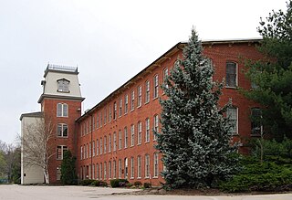
The Hamilton Mill Village Historic District is a historic district encompassing a small mill village in North Kingstown, Rhode Island. It is located on the south side of the Annaquatucket River, near its mouth at Bissell Cove. The village includes two wood-frame mill buildings and a collection of mill worker housing units, which line a short section of Boston Neck Road as well as Salisbury Avenue, Web Avenue, and Martha Road. The most impressive mill building is the main mill, built in 1853 and enlarged in 1866 with a double clerestory roof, something not found in other surviving mills in the state.

The Hope Village Historic District is a historic rural mill settlement within Hope Village in Scituate, Rhode Island. Hope Village is located on a bend in the North Pawtuxet River in the southeastern corner of Scituate. Industrial activity has occurred in Hope Village since the mid-eighteenth century. Surviving industrial and residential buildings in the Historic District date back to the early 19th century. The village center sits at junction of Main Street and North Road. Hope Village radiates out from the center with houses on several smaller side streets in a compact configuration. Currently there is little commercial or industrial activity in Hope Village and none in the Historic District. The present stone mill building on the south side of Hope Village was built in 1844 by Brown & Ives of Providence, expanded in 1871 and modified in 1910. Approximately one quarter of the village's current housing stock was built as mill worker housing by various owners of Hope Mill.
Lafayette Village is a historic district extending along Ten Rod Road in North Kingstown, Rhode Island. It encompasses a linear rural and industrial village, running from the Wickford Junction railroad crossing in the west to Angel Avenue in the east, and includes a number of residential properties on adjacent side streets. The centerpiece of the district is the Rodman Manufacturing Company complex, which operated here for a century beginning in the 1840s. The Robert Rodman Mansion, a Second Empire house with an elaborate porch, stands at 731 Ten Rod Road, and the Walter Rodman House, built in the 1870s, is even more elaborately decorated. Most of the residential stock in the district is mill-related housing built by the Rodmans for their workers.

The Joseph Pierce Farm is an historic farm at 933 Gilbert Stuart Road in North Kingstown, Rhode Island. It consists of 18 acres (7.3 ha) of land, along with an 18th-century farmhouse and a number of 19th-century outbuildings. The oldest portion of the house, its southern ell, was originally built with a gable roof, but this was extended to the north in the late 18th or early 19th century, and given it present gambrel roof and Federal styling. Later additions in the 19th and 20th centuries gave the house its present cruciform appearance. Outbuildings dating to the 19th century include a barn with attached privy, a toolshed, and a henhouse. The complex is a well-preserved reminder of the area's rural heritage.

The Shannock Historic District is a historic mill village located along the Pawcatuck River in the towns of Richmond and Charlestown, Rhode Island. The postal code for Shannock is 02875. The village extends along Old Shannock Road, Railroad Street, and Shannock Village Road between two crossings of the Pawcatuck, which forms the border between the two towns. It lies mainly in Richmond, but extends along the road running southwest and southeast from the two crossings. Two mill complexes are the visual focal points of the village: the Carmichael plant on the west, and the Columbia Narrow Fabrics Company complex near the village center. The buildings in the village are predominantly residential worker housing set close to the road, which were built in the second half of the 19th century. There are two imposing Greek Revival houses, both built c. 1850, and one Late Victorian house, all of which belonged to mill owners. The area was listed on the National Register of Historic Places in 1983.

The Joseph Slocum House is an historic house on Slocum Road in North Kingstown, Rhode Island. It is a 1-1/2 story wood frame house, five bays wide, with a large central chimney. It faces south on the east side of Slocum Road. The house has been dated to the mid-18th century based on architectural evidence; its first documented owner was Joseph Slocum, in the early 19th century. The house is a rare surviving 18th-century farmhouse, a type once numerous in the town.

The former Washington County Courthouse is an historic building at 3481 Kingstown Road in South Kingstown, Rhode Island. Built in 1892, it was added to the National Register of Historic Places in 1992 as Washington County Court House.

The Greystone Historic District is a historic district encompassing the early 20th-century mill village of Greystone in North Providence, Rhode Island. The district most significant elements is the Greystone Mill, a complex of brick industrial buildings on the North Providence side of the Woonasquatucket River, as well as the dam spanning the river and a water tank in Johnston. The village, entirely in North Providence, was developed between 1904 and 1912 by Joseph Benn and Company, the mill proprietors, to provide housing for its workers. The main focus of the village is on junction of Greystone Road and Oakleigh Avenue. The company built a variety of housing types, including duplexes and tenements, which line some of the side streets. There are four houses, dating as far back as 1822, that predate the primary industrial activity here. The most prominent feature of the village is the Greystone (Primitive) Methodist Church on Oakleigh Avenue.

The Manchaug Village Historic District is a historic district encompassing the 19th century industrial village center of Manchaug in Sutton, Massachusetts. Developed in the 1820s around textile mills on the Mumford River, it was the largest industrial area in Sutton, with at least three mill complexes in operation. The district is centered on the junction of Main Street with Manchaug, Putnam Hill, and Whitins Roads.


