
East Coker is a village and civil parish in the South Somerset district of Somerset, England. Its nearest town is Yeovil, two miles (3.2 km) to the north. The village has a population of 1,667. The parish includes the hamlets and areas of North Coker, Burton, Holywell, Coker Marsh, Darvole, Nash, Keyford as well as the southern end of the Wraxhill area.

Chaffcombe is a village and civil parish in Somerset, England, situated 2 miles (3.2 km) north east of Chard in the South Somerset district. The village has a population of 229.

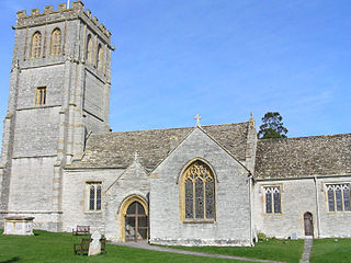
Cucklington is a village and parish in Somerset, England, situated on a hill 3 miles (4.8 km) south east of Wincanton and 4 miles (6.4 km) north west of Gillingham in the South Somerset district, near the Dorset border. The village has a population of 173.

Curry Mallet is a village and parish in Somerset, England. It is on the Fivehead River, 7 miles (11.3 km) east of Taunton in the South Somerset district. The village has a population of 306.
Kingsdon is a village and parish in the South Somerset district of Somerset, England, situated 3 miles (4.8 km) south east of Somerton. The village has a population of 303 but this is set to rise to around 350 once the Kingsdon Manor development is complete. The majority of the houses in the village are clustered on the side of the hill from which there are scenic views across the Somerset countryside.

Paulton is a large village and civil parish, with a population of 5,302, located to the north of the Mendip Hills, very close to Norton Radstock in the unitary authority of Bath and North East Somerset (BANES), England.
Tintinhull Garden, located in Tintinhull, near Yeovil in the English county of Somerset, is a small 20th century garden surrounding a 17th-century Grade I listed house. The property is in the ownership of the National Trust. It is visited by around 25,000 people per year.
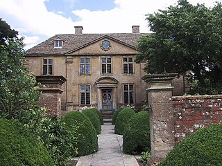
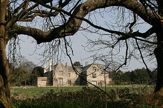
Dinder House, is a Somerset estate with a small country house Grade II Regency listed building in the village of Dinder, in the civil parish of St Cuthbert Out in Somerset. Dinder House was formerly a manor house dating back to the 12th century, but the existing building was constructed between 1799 and 1801 by the Rev William Somerville on the original site. The estate remained as the seat of the Somerville family until the late twentieth century.

Dinder is a small village 2½ miles west of Shepton Mallet, and 2 miles east of Wells in Somerset. It falls within the civil parish of St Cuthbert Out and the Mendip district.
Hunstrete is a small village on the River Chew in the Chew Valley, Bath and North East Somerset, England. It falls within the civil parish of Marksbury and is 8 miles (13 km) from Bristol, and Bath, and 5 miles (8 km) from Keynsham.

Nettlecombe Court and park is an old estate on the northern fringes of the Brendon Hills, within the Exmoor National Park. They are within the civil parish of Nettlecombe, named after the house, and are approximately 3.6 miles (5.8 km) from the village of Williton, in the English county of Somerset. It has been designated by English Heritage as a Grade I listed building.
Combe Florey House in Combe Florey, Somerset, England is a country house dating from the early 18th century. It replaced an Elizabethan manor house which was pulled down after the English Civil War. The gatehouse to the original manor survives. In the mid-20th century, the house was home to the writer Evelyn Waugh who died there in 1966 and is buried next to the churchyard of the adjacent Church of St Peter & St Paul. Combe Florey House is a Grade II listed building.

East Quantoxhead is a village in the district of Somerset West and Taunton, 3 miles (5 km) from West Quantoxhead, 4 miles (6 km) east of Williton, and 13 miles (21 km) west of Bridgwater, within the Quantock Hills Area of Outstanding Natural Beauty in Somerset, England.

South Petherton is a village and civil parish in the South Somerset district of Somerset, England, located 5 miles (8 km) east of Ilminster and 5 miles (8 km) north of Crewkerne. The parish had a population of 3,367 in 2011 and includes the smaller village of Over Stratton and the hamlets of Compton Durville, Drayton, Wigborough and Yeabridge. The River Parrett forms the eastern boundary of the parish. The village is approximately 2 miles (3 km) from East Lambrook, Martock and Lopen.

The Court House in East Quantoxhead, Somerset, England has a medieval tower and other parts of the building which date from the 17th century. It has been designated as a Grade I listed building.
Poundisford Park north of Pitminster, Somerset, England is an English country house that typifies progressive housebuilding on the part of the West Country gentry in the mid-16th century. The main house was built for William Hill around 1550 and has been designated as a Grade I listed building.
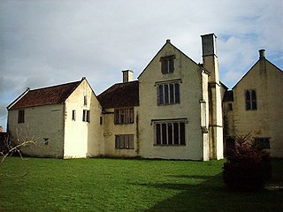
Gurney Manor in Cannington, Somerset, England is a 13th-century manor house with an attached chapel wing. It is now supported by the Landmark Trust and is available as holiday accommodation. It has been designated as a Grade I listed building and is considered notable partly due to the substantial survival of medieval construction throughout.

Fairfield House is a historic house in Stogursey, Somerset, England. A house existed on the site from the 12th century and it has been owned by the same family since that time. The current building is largely 16th-century, but has undergone various remodellings since then. It is designated as a Grade II* listed building.

Petherton Park was a Deer park around North Petherton within the English county of Somerset.

The Anglican Church of St Lawrence in Cucklington, Somerset, England, was built in the 13th century. It is a Grade II* listed building.

