Shannon, New Zealand

Last updated

Shannon
Town
Percy Nation Memorial - park, Shannon, New Zealand 47.JPG
Te Maire Park
Shannon, New Zealand
Coordinates: 40°32′49.92″S175°24′38.52″E / 40.5472000°S 175.4107000°E / -40.5472000; 175.4107000
Country New Zealand
Region Manawatū-Whanganui region
Territorial authority Horowhenua District
Wards
  • Miranui General Ward
  • Horowhenua Māori Ward
Founded byWellington and Manawatu Railway Company.
Named for George Vance Shannon
Electorates
Government
  Territorial Authority Horowhenua District Council
  Regional council Horizons Regional Council
   Horowhenua Mayor Bernie Wanden
   Rangitīkei MP Suze Redmayne
   Te Tai Hauāuru MP Debbie Ngarewa-Packer
Area
[1]
  Total2.94 km2 (1.14 sq mi)
Population
 (June 2023) [2]
  Total1,610
  Density550/km2 (1,400/sq mi)
Time zone UTC+12 (NZST)
  Summer (DST) UTC+13 (NZDT)
Postcode
4821
Area Code06

Shannon is a small town in the Horowhenua District of New Zealand's North Island. it is located 28 kilometres southwest of Palmerston North and 15 kilometres northeast of Levin.

Contents

The main activities in the district are dairy, sheep, and mixed farming. Mangaore (5 kilometres east) is the residential township for the nearby Mangahao hydro-electric power station, which was the second power station to be built in New Zealand and the first to be built by the government. The power station is the oldest still supplying power to New Zealand grid. [3] The Manawatu River lies to the west of the town.

A large percentage of the population is Māori with the local primary school representing kaupapa Māori.

History

Shannon originally adjoined extensive swamps and was a headquarters for flax milling. The land on which the township later stood was part of an endowment of 215,000 acres (870 km2) acquired about 1881 by the Wellington and Manawatu Railway Company (WMR). At first the company had intended to extend its railway from Levin to Foxton, but afterwards it proceeded to develop and open up the endowment area. Accordingly, the line was laid along the present route via Shannon. The town is considered to have been founded on 8 March 1887 when the first auction of town land was held. Shannon was named after George Vance Shannon (1842–1920), a director of the WMR. It was constituted a borough in 1917. [4]

Mangahao Power Station tragedy

On 2 July 1922 seven workers were poisoned by carbon monoxide while digging the tunnels for the Mangahao Power Station.

When the extractor fan broke down, Bernard Butler and foreman Alfred Maxwell were killed by suffocation from the fumes being emitted by their oil engines. A subsequent search party of five of their colleagues also suffocated and perished in the tunnel. [5]

Demographics

Shannon is defined by Statistics New Zealand as a small urban area and covers 2.94 km2 (1.14 sq mi). [1] It had an estimated population of 1,610 as of June 2023, with a population density of 548 people per km2.

Historical population
YearPop.±% p.a.
20061,362    
20131,236−1.38%
20181,398+2.49%
Source: [6]

Shannon had a population of 1,398 at the 2018 New Zealand census, an increase of 162 people (13.1%) since the 2013 census, and an increase of 36 people (2.6%) since the 2006 census. There were 537 households, comprising 681 males and 720 females, giving a sex ratio of 0.95 males per female. The median age was 40.4 years (compared with 37.4 years nationally), with 291 people (20.8%) aged under 15 years, 261 (18.7%) aged 15 to 29, 630 (45.1%) aged 30 to 64, and 216 (15.5%) aged 65 or older.

Ethnicities were 78.5% European/Pākehā, 43.1% Māori, 2.8% Pasifika, 1.7% Asian, and 1.3% other ethnicities. People may identify with more than one ethnicity.

The percentage of people born overseas was 7.3, compared with 27.1% nationally.

Although some people chose not to answer the census's question about religious affiliation, 53.6% had no religion, 30.9% were Christian, 1.7% had Māori religious beliefs, 0.9% were Buddhist and 2.4% had other religions.

Of those at least 15 years old, 87 (7.9%) people had a bachelor's or higher degree, and 393 (35.5%) people had no formal qualifications. The median income was $21,300, compared with $31,800 nationally. 48 people (4.3%) earned over $70,000 compared to 17.2% nationally. The employment status of those at least 15 was that 405 (36.6%) people were employed full-time, 153 (13.8%) were part-time, and 84 (7.6%) were unemployed. [6]

Town facilities and attractions

Club Hotel Shannon Hotel, Manawatu, New Zealand, 8 December 2006.jpg
Club Hotel
Albion Hotel, which burnt down in 2013 Albion Tavern, Shannon, Manawatu, New Zealand, 8 December 2006.jpg
Albion Hotel, which burnt down in 2013

Today Shannon sits as a passing through point between Palmerston North, the Horowhenua, Kapiti and Wellington with public toilet facilities, two cafes, a dairy, an RD1 rural supply store, a fish and chip shop, a primary school, a Four Square grocer, a petrol station and an art gallery.

The township has rugby, netball and lawn bowling clubs.

Shannon Railway Station is the most substantial of only a few remaining physical relics of the WMR, which was acquired by the national New Zealand Railways Department in 1908. The station is a stop for the Capital Connection long distance commuter train between Wellington and Palmerston North.

Owlcatraz

Owlcatraz was a native bird and wildlife park and one of Shannon's prime attractions. It was opened in 1997 by Ross & Janet Campbell and operated by them until it was sold 23 years later. Owlcatraz had over one million visitors in that time. [7]

Helen's town / Flaxville

The town used to house the creative work of Helen Pratt which consisted of a large model town with miniature versions of many New Zealand landmarks and buildings, a working train and carnival, all hand made. The display used to be housed at 36 Stout Street until the building was closed in the 1990s.

Helen subsequently built another town. Helen's collection was shown to the public for brief period of time known as Flaxville at 16 Ballance Street. Helen's Collection has left Shannon and was later displayed at Murrayfield, a museum between Shannon and Levin on State 57. [8]

Education

Shannon School is a co-educational state primary school for Year 1 to 8 students, [9] [10] with a roll of 96 as of February 2024. [11]

The nearest high schools located in levin and Foxton both towns are within a 10-16 minute drive offering three high school options, Waiopehu college, Horowhenua college and Manawatu college

Schools in the nearest major city Palmerston North could also considered with a short drive ranging from around 20-30 minutes

Related Research Articles

<span class="mw-page-title-main">Pahiatua</span> Town in Manawatū-Whanganui, New Zealand

Pahiatua is a rural service town in the south-eastern North Island of New Zealand with a population of 2,840. It is between Masterton and Woodville on State Highway 2 and along the Wairarapa Line railway, 60 kilometres (37 mi) north of Masterton and 30 kilometres (19 mi) east of Palmerston North. It is usually regarded as being in the Northern Wairarapa. For local government purposes, since 1989 it has been in the Tararua District, which encompasses Eketāhuna, Pahiatua, Woodvillle, Dannevirke, Norsewood and the far east of the Manawatū-Whanganui region.

<span class="mw-page-title-main">Palmerston North</span> City in North Island, New Zealand

Palmerston North is a city in the North Island of New Zealand and the seat of the Manawatū-Whanganui region. Located in the eastern Manawatu Plains, the city is near the north bank of the Manawatu River, 35 km (22 mi) from the river's mouth, and 12 km (7 mi) from the end of the Manawatū Gorge, about 140 km (87 mi) north of the capital, Wellington. Palmerston North is the country's eighth-largest urban area, with an urban population of 82,500. The estimated population of Palmerston North city is 91,800.

<span class="mw-page-title-main">Foxton, New Zealand</span> Town in Manawatū-Whanganui, New Zealand

Foxton is a town in the Manawatū-Whanganui region of New Zealand - on the lower west coast of the North Island, in the Horowhenua district, 30 km (19 mi) southwest of Palmerston North and just north of Levin. The town is located close to the banks of the Manawatū River. It is situated on State Highway 1, roughly in the middle between Tongariro National Park and Wellington.

<span class="mw-page-title-main">Levin, New Zealand</span> Town in Manawatū-Whanganui, New Zealand

Levin is the largest town and seat of the Horowhenua District, in the Manawatū-Whanganui region of New Zealand's North Island. It is located east of Lake Horowhenua, around 95 km north of Wellington and 50 km southwest of Palmerston North.

<span class="mw-page-title-main">Manawatū-Whanganui</span> Region of New Zealand

Manawatū-Whanganui is a region in the lower half of the North Island of New Zealand, whose main population centres are the cities of Palmerston North and Whanganui. It is administered by the Manawatū-Whanganui Regional Council, which operates under the name Horizons Regional Council.

<span class="mw-page-title-main">Horowhenua District</span> Territorial authority district in Manawatū-Whanganui, New Zealand

Horowhenua District is a territorial authority district on the west coast of the North Island of New Zealand, administered by Horowhenua District Council. Located north of Wellington and Kāpiti, it stretches from slightly north of the town of Ōtaki in the south to just south of Himatangi in the north, and from the coast to the top of the Tararua Range. It is in the Manawatū-Whanganui local government region. The name Horowhenua is Māori for landslide.

<span class="mw-page-title-main">Manawatū District</span> Territorial authority district in New Zealand

Manawatū District is a territorial authority district in the Manawatū-Whanganui local government region in the North Island of New Zealand, administered by Manawatū District Council. It includes most of the area between the Manawatū River in the south and the Rangitīkei River in the north, stretching from slightly south of the settlement of Himatangi in the south, to just south of Mangaweka in the north, and from the Rangitīkei River to the top of the Ruahine Range in the east. It does not include the Foxton area and the mouth of the Manawatū River, or Palmerston North City. Its main town is Feilding. The district has an area of 2,624 km².

<span class="mw-page-title-main">Woodville, New Zealand</span> Town in Manawatū-Whanganui, New Zealand

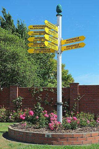
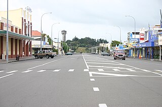
Woodville, previously known as The Junction, is a small town in the southern North Island of New Zealand, 75 km north of Masterton and 25 km east of Palmerston North. The 2013 census showed that 1401 people reside in Woodville.

<span class="mw-page-title-main">Himatangi</span> Settlement in Manawatū-Whanganui Region, New Zealand

Himatangi is a small settlement in the Manawatū-Whanganui region of New Zealand's North Island. It is located at the junction of State Highways 1 and 56, 25 kilometres west of Palmerston North, and seven kilometres east of the coastal settlement of Himatangi Beach.

<span class="mw-page-title-main">Foxton Beach</span> Town in Manawatū-Whanganui, New Zealand

Foxton Beach is a small settlement in the Horowhenua District of the Manawatū-Whanganui region of New Zealand's North Island. It is located on the South Taranaki Bight at the mouth of the Manawatu River, 35 kilometres southwest of Palmerston North, and six kilometres west of Foxton. Foxton Beach has a permanent population of around 2000 people. The town is a popular holiday destination due mainly to its beach and the bird sanctuary at the Manawatu Estuary.

Bunnythorpe is a village in the Manawatū-Whanganui region of New Zealand's North Island, 10 km (6 mi) north of the region's major city, Palmerston North. Dairy farms predominate the surrounding area but the community facilities include Bunnythorpe School, with a roll of about 80 pupils as of 2010 as well as a Rugby Football Club, Country Club and several manufacturing plants. The population was 687 in the 2018 census.

<span class="mw-page-title-main">Foxton Branch</span> Railway line in New Zealand

The Foxton Branch was a railway line in New Zealand. It began life as a tramway, reopened as a railway on 27 April 1876, and operated until 18 July 1959. At Himatangi there was a junction with the Sanson Tramway, a line operated by the Manawatu County Council that was never upgraded to the status of a railway.

<span class="mw-page-title-main">NZR N class</span>

The N class were 12 steam locomotives that operated on the national rail network of New Zealand. They were built in three batches, including one batch of two engines for the private Wellington and Manawatu Railway Company, the WMR, by the Baldwin Locomotive Works in 1885, 1891, and 1901. Previously the N class designation had been applied between 1877 and 1879 to Lady Mordaunt, a member of the B class of 1874.

<span class="mw-page-title-main">Te Horo</span> Settlement in Wellington Region, New Zealand

Te Horo and Te Horo Beach are two localities on the Kāpiti Coast of New Zealand's North Island. Te Horo Beach is the larger of the two settlements and, as its name implies, is located on the Tasman Sea coast. Te Horo is located to the east, a short distance inland. They are situated between Peka Peka and Waikanae to the south and Ōtaki to the north. "Te Horo" in the Māori language means "the landslide".

Longburn is a rural settlement just outside Palmerston North in the Manawatū-Whanganui area of New Zealand. Made up of large dairy processing plants Longburn is often mistaken to be a small township and not seen as a large satellite town of Palmerston North. The township is home to both Longburn School and Longburn Adventist College.

<span class="mw-page-title-main">Mangahao Power Station</span> Hydroelectric power station near Shannon, New Zealand

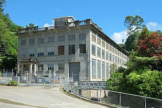
Mangahao Power Station is a hydroelectric power station near the town of Shannon, New Zealand. After being delayed by war, access road construction and foundation testing was started by late 1919 and the station opened in November 1924. It makes use of the Mangahao River, through a series of tunnels and pipelines totalling 4.8 kilometers in the Tararua Ranges. It is jointly owned and operated by Todd Energy and King Country Energy.

<span class="mw-page-title-main">Wellington and Manawatu Railway Company</span>

The Wellington and Manawatu Railway Company was a private railway company that built, owned and operated the Wellington-Manawatu railway line between Thorndon in Wellington, the capital of New Zealand, and Longburn, near Palmerston North in the Manawatu, between 1881 and 1908, when it was acquired by the New Zealand Government Railways. Its successful operation in private ownership was unusual for early railways in New Zealand.

<span class="mw-page-title-main">Shannon railway station</span> Railway station in New Zealand

Shannon railway station is a station on the North Island Main Trunk serving Shannon in the Horowhenua District of New Zealand. It is served by the Capital Connection long distance commuter train between Wellington and Palmerston North.

<span class="mw-page-title-main">Longburn railway station</span> Defunct railway station in New Zealand

Longburn railway station was a station in Longburn, on the North Island Main Trunk in New Zealand. The platform, which is across from the Fonterra Factory, remains but the structure has been demolished.

<span class="mw-page-title-main">Awapuni railway station</span> Defunct railway station in New Zealand

Awapuni railway station was a station in Kairanga County, on the Foxton Branch and, from 1908, the North Island Main Trunk in New Zealand, now in the Palmerston North suburb of Awapuni. It was beside the Mangaone Stream, near its confluence with the Kawau Stream, about 400 m (440 yd) west of Maxwells Line on the north side of Pioneer Highway. Nothing remains of the former station, except a wide verge, partly occupied by a cycleway, built in 2015.

References

  1. 1 2 "ArcGIS Web Application". statsnz.maps.arcgis.com. Retrieved 19 May 2023.
  2. "Population estimate tables - NZ.Stat". Statistics New Zealand . Retrieved 25 October 2023.
  3. "Mangahao Power Station | Engineering New Zealand". www.engineeringnz.org. Retrieved 15 May 2024.
  4. Shannon in the 1966 Encyclopaedia of New Zealand
  5. "Shannon Library hosts exhibition to remember Mangahao tragedy". 4 July 2022.
  6. 1 2 "Statistical area 1 dataset for 2018 Census". Statistics New Zealand. March 2020. Shannon (235400). 2018 Census place summary: Shannon
  7. "Ross and Janette Campbell: Escape from Owlcatraz". Radio New Zealand . 8 August 2020.
  8. "Helenstown | Spectrum | Radio New Zealand National". Radio New Zealand. Retrieved 5 June 2016.
  9. "Official School Website". shannon.school.nz.
  10. "Ministry of Education School Profile". educationcounts.govt.nz. Ministry of Education.
  11. "Education Review Office Report". ero.govt.nz. Education Review Office.