
South Derbyshire is a local government district in Derbyshire, England. The population of the local authority at the 2011 Census was 94,611. It contains a third of the National Forest, and the council offices are in Swadlincote. The district also forms part of the wider Burton upon Trent and Swadlincote Green Belt, which covers the towns of Burton-upon-Trent in East Staffordshire and Swadlincote in South Derbyshire. The district is also landlocked between the districts of Derby, Derbyshire Dales, East Staffordshire, Erewash District, Lichfield District, North Warwickshire, North West Leicestershire and Tamworth.

Aston-on-Trent is a village and civil parish in the South Derbyshire district, in the county of Derbyshire, England. The parish had a population of 1,682 at the 2011 Census. It is adjacent to Weston-on-Trent and near Chellaston, very close to the border with Leicestershire.

Shardlow is a village in Derbyshire, England about 6 miles (9.7 km) southeast of Derby and 11 miles (18 km) southwest of Nottingham. Part of the civil parish of Shardlow and Great Wilne, and the district of South Derbyshire, it is also very close to the border with Leicestershire, defined by the route of the River Trent which passes close to the south. Just across the Trent is the Castle Donington parish of North West Leicestershire.
Weston-on-Trent is a village and civil parish in the South Derbyshire district of Derbyshire. The population of the civil parish at the 2011 census was 1,239. It is to the north of the River Trent and the Trent and Mersey Canal. Nearby places include Aston-on-Trent, Barrow upon Trent, Castle Donington and Swarkestone.

Great Wilne is a small village in Derbyshire, England on the border with Leicestershire. It is 7 miles (11 km) south east of Derby. It is a village split from its church of St Chad's by the river. The church is at the very small hamlet of Church Wilne which can only be approached by a short walk via the bridge over the River Derwent, or by a fair car journey which necessitates travelling out of the county. The population at the 2011 Census is included in the civil parish of Shardlow and Great Wilne.
Boylestone is a village and civil parish in the Derbyshire Dales district of Derbyshire, England. According to the 2001 census it had a population of 165, increasing to 318 at the 2011 Census. The village is situated about eight miles east of Uttoxeter.
South East Derbyshire was a rural district in Derbyshire, England from 1894 to 1974. It covered an area to the south-east of Derby.

Morley is a village and civil parish within the Borough of Erewash in Derbyshire, England.
Ockbrook and Borrowash is a civil parish in the borough of Erewash in the county of Derbyshire in England.

Brailsford is a small red-brick village and civil parish in Derbyshire on the A52 midway between Derby and Ashbourne. The parish also includes Brailsford Green. The civil parish population at the 2011 Census was 1,118. The village has a pub, a golf club, a post office and a school. There are many fine houses in the district including two 20th-century country houses: Brailsford Hall built in 1905 in Jacobean style, and Culland Hall.

Sawley is a village and civil parish within the Borough of Erewash, in southeast Derbyshire, England. With a slightly higher than average number of people over 65, the population of just the civil parish was measured at 6,629 as at the 2011 Census.

Smalley is a village on the main A608 Heanor to Derby road in Derbyshire in the East Midlands of England. The population of the civil parish as of the 2011 census was 2,784.

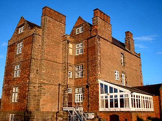
Shardlow Hall is a 17th-century former country house at Shardlow, Derbyshire now in use as commercial offices. It is a Grade II* listed building which is officially listed on the Buildings at Risk Register.
Chilcote is a village and civil parish in the North West Leicestershire district of Leicestershire, England. Until 1897 it was in Derbyshire. The parish had a population of 108 according to the 2001 census, including Stretton-en-le-Field and increasing to 200 at the 2011 census.
Stanley and Stanley Common is a civil parish in south-east Derbyshire in the East Midlands of England. It comprises the villages of Stanley and Stanley Common. The population of the civil parish as of the 2011 census was 2,100.
Mapperley is a village and civil parish in the Amber Valley district of Derbyshire, England, situated 7 miles (11 km) northeast of Derby and 2 miles (3 km) northwest of Ilkeston. In the 2001 census it had a population of 253, increasing to 289 at the 2011 Census.

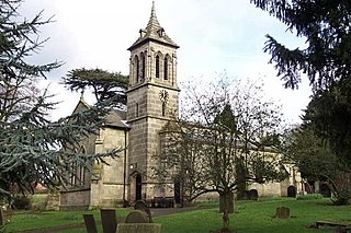
St James’ Church, Swarkestone is a Grade II* listed parish church in the Church of England in Swarkestone, Derbyshire.

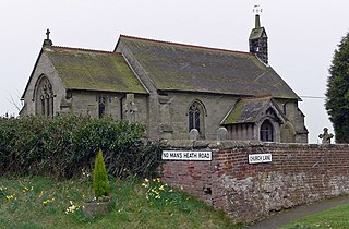
St James’ Church, Shardlow is a Grade II listed parish church in the Church of England in Shardlow, Derbyshire.
Shardlow and Great Wilne is a civil parish in the South Derbyshire district of Derbyshire, England. The parish contains 48 listed buildings that are recorded in the National Heritage List for England. Of these, one is listed at Grade II*, the middle of the three grades, and the others are at Grade II, the lowest grade. The parish contains the village of Shardlow, the smaller village of Great Wilne, and the surrounding area. Shardlow is at the southern end of the Trent and Mersey Canal, and a number of buildings relating to the canal are listed, including warehouses, mileposts, a bridge and a lock. Most of the other listed buildings are houses, cottages and associated structures, farmhouses and farm buildings. The rest of the listed buildings include public houses, a church and associated structures including a war memorial, a road milepost, the sign from a former toll house, and a school.