Topeka is the capital city of the U.S. state of Kansas and the seat of Shawnee County. It is along the Kansas River in the central part of Shawnee County, in northeast Kansas, in the Central United States. As of the 2020 census, the population of the city was 126,587. The Topeka metropolitan statistical area, which includes Shawnee, Jackson, Jefferson, Osage, and Wabaunsee Counties, had a population of 233,870 in the 2010 census.

Miami County is a county located in east-central Kansas and is part of the Kansas City metropolitan area. Its county seat and most populous city is Paola. As of the 2020 census, the county population was 34,191. The county was named for the Miami tribe.

Johnson County is a county in the U.S. state of Kansas, along the border of the state of Missouri. Its county seat is Olathe. As of the 2020 census, the population was 609,863, the most populous county in Kansas. The county was named after Thomas Johnson, a Methodist missionary who was one of the state's first settlers. Largely suburban, the county contains a number of suburbs of Kansas City, Missouri, including Overland Park, a principal city of and second most populous city in the Kansas City Metropolitan Area.
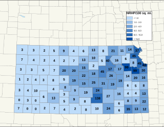
There are over 1,600 buildings, sites, districts, and objects in Kansas listed on the National Register of Historic Places in Kansas. NRHP listings appear in 101 of the state's 105 counties.

Shawnee Methodist Mission, also known as the Shawnee Mission, which later became the Shawnee Indian Manual Labor School, is located in Fairway, Kansas, United States. Designated as a National Historic Landmark in 1968, the Shawnee Methodist Mission is operated by the city as a museum. The site is owned by the Kansas Historical Society and administered as the Shawnee Indian Mission State Historic Site.

Ward Parkway is a boulevard in Kansas City, Missouri, United States. Ward Parkway begins at Brookside Boulevard on the eastern edge of the Country Club Plaza and travels west 2.8 miles along Brush Creek as U.S. Route 56 before turning south near Kansas-Missouri state line. It continues south for 4 miles, terminating at Wornall Road near Bannister Road. A short spur, Brush Creek Parkway, connects Ward Parkway to Shawnee Mission Parkway at State Line Road.

Arborway consists of a four-lane, divided parkway and a two-lane residential street in the Jamaica Plain neighborhood of Boston, Massachusetts, United States. It was designed by Frederick Law Olmsted in the 1890s as the southern-most carriage road in a series of parkways connecting parks from Boston Common in downtown Boston to Franklin Park in Roxbury. This park system has since become known as the Emerald Necklace.

Grinter Place is a house on the National Register of Historic Places above the Kansas River in the Muncie neighborhood of Kansas City, Kansas.

The County Line Bowstring is a bridge located near unincorporated Hollis, Kansas, United States, that is listed on the National Register of Historic Places. It spans West Creek on the border between Cloud and Republic counties and has a wooden deck with a bowstring pony truss.
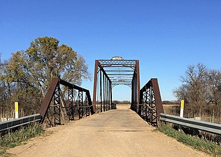
Pott's Ford Bridge is a bridge 1/2 mile south of Glasco, Kansas, USA that spans the Solomon River in Cloud County, Kansas. It has a wooden deck with three bowstring pony trusses and one Pratt pony truss. The lengths of the trusses are 48 feet (15 m), 46 feet (14 m), and 149 feet (45 m) for the bowstring trusses, and 72 feet (22 m) for the Pratt truss. It was built in 1884 by the Wrought Iron Bridge Company of Canton, Ohio.
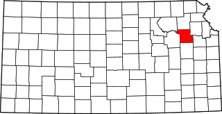
This is a list of the National Register of Historic Places listings in Shawnee County, Kansas.

The National Register of Historic Places listings in Wyandotte County, Kansas are 44 properties and districts, including one National Historic Landmark. Another two properties have been removed.
The Keystone Bridge Company, founded in 1865 by Andrew Carnegie, was an American bridge building company. It was one of the 28 companies absorbed into the American Bridge Company in 1900. The company advertised its services for building steel, wrought iron, wooden railway and road bridges. It held a patent for wrought iron bridges and also supplied wrought iron columns for buildings. Thomas Carnegie worked for Keystone Bridge as treasurer for roughly 20 years, from the founding of the company until his death in 1886.

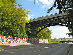
The National Register of Historic Places listings in downtown Kansas City, Missouri is intended to be a complete list of the properties and districts on the National Register of Historic Places in downtown Kansas City, Missouri, United States. Downtown Kansas City is defined as being roughly bounded by the Missouri River to the north, 31st Street to the south, Troost Avenue to the east, and State Line Road to the west. The locations of National Register properties and districts are in an online map.
This is a list of the National Register of Historic Places listings in Kansas City, Missouri outside downtown.

The West James Street Overpass is a historic bridge in Redfield, Arkansas. It carries West James Street across the Union Pacific railroad tracks near the center of the community. It is a timber trestle structure, with six spans over a total length of 131 feet (40 m), a deck width of 20 feet (6.1 m), and an overall width of 26 feet (7.9 m). Its abutments are a combination of wood and concrete, and the posts supporting the trestles are mounted on concrete footings. It was built in 1924. The bridge was listed on the National Register of Historic Places in 1995.

The State Street Bridge is a historic structure located in Mason City, Iowa, United States. The span carries East State Street over Willow Creek for 62 feet (19 m). In the mid- to late-19th century, State Street was the only road into town from the east. There was a bridge at this crossing from at least 1875, but it is unknown what kind of bridges or how many served the crossing. This bridge was completed in 1903 and features a barrel arch with filled spandrels. Although the original guardrails have been replaced, it is the oldest roadway arch bridge in Cerro Gordo County. It was listed on the National Register of Historic Places in 1998.