Buildings, sites, districts, and objects in California listed on the National Register of Historic Places:

This is a list of properties and historic districts in Arkansas that are listed on the National Register of Historic Places. There are more than 2,600 listings in the state, including at least 8 listings in each of Arkansas's 75 counties.

Spirit Mountain, also known as Avi Kwa' Ame in Mojave, is a mountain in the Laughlin, Nevada area that is listed on the United States National Register of Historic Places. It is part of the Newberry Mountains in Nevada and the summit is the highest point in the Spirit Mountain Wilderness.

The Nevada Democratic Presidential Caucuses took place on January 19, 2008 after having been moved from a later date by the Nevada Democratic Party. The Nevada Democratic Caucus was considered important in determining the eventual party nominee, as many described it as the "Bellwether of the West" seeing as how it is the first Western state to vote in the Democratic Presidential Primary season.

This is a list of the National Register of Historic Places listings in Clark County, Ohio.
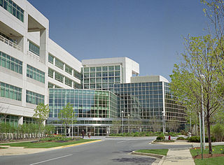
The Clark County Shooting Complex, located on the northern outskirts of Las Vegas, Nevada, is the largest shooting facility in the United States. The 2,900 acres (1,200 ha) park is being built in stages by Clark County, Nevada. At full build out is anticipated that only 900 acres (360 ha) will be developed with the rest of the site serving as a buffer for the surrounding community. The park is located at the northern end of Decatur Blvd in unincorporated Clark County, just north of the City of Las Vegas boundary.
Tule Springs Archaeological Site is an archeological site listed on the National Register of Historic Places that is located in the Las Vegas Valley of Nevada, United States. It is one of a few sites in the United States where humans were once thought to have lived alongside, and potentially hunted, extinct Ice Age megafauna, although this view is not supported by the available scientific data and is no longer generally accepted.

The Clark Avenue Railroad Underpass, also known as the Bonanza Underpass, is a bridge and underpass in Las Vegas, Nevada, United States that is listed on the National Register of Historic Places. The bridge is so named since at the time of construction it crossed Clark Avenue which was later renamed to Bonanza Road. The underpass is currently part of Nevada State Route 579.

LDS Moapa Stake Office Building, also known as the Virmoa Maternity Hospital, is listed on the National Register of Historic Places in Overton, Nevada. It was built between 1917 and 1919 to serve the community of Moapa Valley as a local office, classroom and records repository for the LDS Church. In 1939, the local stake decided to relocate their offices to Las Vegas as travel between the communities became easier. The building then sat vacant.

The Potosi mining district, or Potosi, was an area in Clark County of southern Nevada, U.S. It is listed on the National Register of Historic Places and includes three structures. The town was named after the famous silver-mining city of Potosi, Bolivia.
The National Archives Site is an archeological site at the National Archives facility in College Park, Prince George's County, Maryland. The site contains archeological remains from prehistoric settlements during the Late Archaic period, c. 4000-1500 B.C. Stone artifacts recovered through archeological testing indicate that this camp served as a place of stone tool manufacture and probably as a staging point for hunting and foraging. Physical integrity of the prehistoric component is high, with little plow disturbance or admixture with artifacts from other periods. The presence of a small number of other artifacts, including the projectile points, a spokeshave, and utilized flakes, indicates that the site also served in other hunting and foraging pursuits. It is one of a relatively small percentage of known prehistoric properties in Maryland with undisturbed archeological deposits.
The Bumpstead Archeological Site is an archeological site located near Elkton, Cecil County, Maryland. The site is one of a group of interrelated sites illustrating the various phases of stone tool production and living area activities.
The Heath Farm Camp Archeological Site is an archeological site located near Elkton, Cecil County, Maryland. The site is one of a group of interrelated sites illustrating the various phases of stone tool production and living area activities.
The Heath Farm Jasper Quarry Archeological Site is an archeological site located near Elkton, Cecil County, Maryland. The site is one of a group of interrelated sites illustrating the various phases of stone tool production and living area activities.
The Iron Hill Cut Jasper Quarry Archeological Site is an archeological site located near Elkton, Cecil County, Maryland. The site is one of a group of interrelated sites illustrating the various phases of stone tool production and living area activities.
The McCandless Archeological Site is an archeological site located near Elkton, Cecil County, Maryland. The site is one of a group of interrelated sites illustrating the various phases of stone tool production and living area activities.
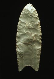
Dave Canyon, Se'aquada, Table Mountain is an archeological site near Lovelock, Nevada, United States, that was listed on the National Register of Historic Places in 2005. It has also been known as Cornish Canyon, and as Site 26 PE3091, as BLM # CrNV-22-7676. The National Register's NRIS database listing indicates the site had "agriculture/subsistence" and "industry/processing/extraction" functions.

Grimes Point, in Churchill County, Nevada near Fallon, is a 720-acre (290 ha) archeological site that was listed on the U.S. National Register of Historic Places in 1972. It was listed for its potential to yield future information.

The Lagomarsino Petroglyph Site (26ST1) is a 65-acre (26 ha) archeological site of petroglyphs, located in Storey County, Nevada near Virginia City. It was listed for its potential to yield information in the future, and includes one contributing site with approximately 2000 items.
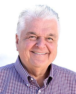
Stephen F. Sisolak is an American businessman and politician serving as the 30th and current Governor of Nevada, since 2019. A member of the Democratic Party, he previously served as Chair of the Clark County Commission. After becoming involved in several civic causes and government projects, Sisolak won election to the Nevada Board of Regents and served from 1999 to 2008. In 2008, he won election to the Clark County Commission and was reelected in 2012 and 2016. In 2018, Sisolak won the Democratic nomination for Governor of Nevada, defeating Clark County Commission colleague Chris Giunchigliani in the primary election.