Sheffield, Iowa

Last updated
Sheffield, Iowa
Sheffield Iowa 20090322 Sign.JPG
Franklin County Iowa Incorporated and Unincorporated areas Sheffield Highlighted.svg
Location of Sheffield, Iowa
Coordinates: 42°53′37″N93°13′1″W / 42.89361°N 93.21694°W / 42.89361; -93.21694 Coordinates: 42°53′37″N93°13′1″W / 42.89361°N 93.21694°W / 42.89361; -93.21694
Country Flag of the United States.svg  United States
State Flag of Iowa.svg  Iowa
County Franklin
Area
[1]
  Total5.60 sq mi (14.50 km2)
  Land5.57 sq mi (14.42 km2)
  Water0.03 sq mi (0.07 km2)
Elevation
1,076 ft (328 m)
Population
 (2020)
  Total1,130
  Density202.95/sq mi (78.35/km2)
Time zone UTC-6 (Central (CST))
  Summer (DST) UTC-5 (CDT)
ZIP code
50475
Area code 641
FIPS code 19-72210
GNIS feature ID0461552
Website www.sheffieldiowa.com

Sheffield is a city in Franklin County, Iowa, United States. The population was 1,130 at the time of the 2020 census. [2]

Contents

History

Sheffield was platted in 1874, and it was named for a personal friend of the founder's. Sheffield was incorporated in 1876. [3]

Geography

Sheffield, IA is located at 42°53′37″N93°13′1″W / 42.89361°N 93.21694°W / 42.89361; -93.21694 (42.893649, −93.217067). [4]

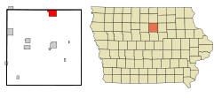
According to the United States Census Bureau, the city has a total area of 5.58 square miles (14.45 km2), of which 5.55 square miles (14.37 km2) is land and 0.03 square miles (0.08 km2) is water. [5]

Demographics

Buildings in downtown Sheffield Sheffield Iowa 20090322 Old City Hall.JPG
Buildings in downtown Sheffield
Historical populations
YearPop.±%
1880 307    
1890 610+98.7%
1900 688+12.8%
1910 824+19.8%
1920 1,106+34.2%
1930 1,057−4.4%
1940 1,060+0.3%
1950 1,163+9.7%
1960 1,156−0.6%
1970 1,070−7.4%
1980 1,224+14.4%
1990 1,174−4.1%
2000 930−20.8%
2010 1,172+26.0%
2020 1,130−3.6%
Source: "U.S. Census website". United States Census Bureau . Retrieved 2020-03-28. and Iowa Data Center
Source:
U.S. Decennial Census [6] [2]

2010 census

As of the census [7] of 2010, there were 1,172 people, 480 households, and 323 families living in the city. The population density was 211.2 inhabitants per square mile (81.5/km2). There were 510 housing units at an average density of 91.9 per square mile (35.5/km2). The racial makeup of the city was 98.2% White, 0.2% African American, 0.3% Native American, 0.5% Asian, 0.1% Pacific Islander, 0.1% from other races, and 0.6% from two or more races. Hispanic or Latino of any race were 0.9% of the population.

There were 480 households, of which 27.7% had children under the age of 18 living with them, 58.5% were married couples living together, 5.4% had a female householder with no husband present, 3.3% had a male householder with no wife present, and 32.7% were non-families. 29.8% of all households were made up of individuals, and 14.6% had someone living alone who was 65 years of age or older. The average household size was 2.36 and the average family size was 2.93.

The median age in the city was 44.6 years. 23.5% of residents were under the age of 18; 6.7% were between the ages of 18 and 24; 20.3% were from 25 to 44; 26.6% were from 45 to 64; and 22.7% were 65 years of age or older. The gender makeup of the city was 47.4% male and 52.6% female.

2000 census

As of the census [8] of 2000, there were 930 people, 369 households, and 259 families living in the city. The population density was 167.4 inhabitants per square mile (64.6/km2). There were 397 housing units at an average density of 71.5 per square mile (27.6/km2). The racial makeup of the city was 99.14% White, 0.32% Asian, and 0.54% from two or more races. Hispanic or Latino of any race were 0.65% of the population.

There were 369 households, out of which 30.4% had children under the age of 18 living with them, 58.5% were married couples living together, 8.4% had a female householder with no husband present, and 29.8% were non-families. 27.6% of all households were made up of individuals, and 20.9% had someone living alone who was 65 years of age or older. The average household size was 2.37 and the average family size was 2.86.

23.4% are under the age of 18, 6.8% from 18 to 24, 21.3% from 25 to 44, 22.9% from 45 to 64, and 25.6% who were 65 years of age or older. The median age was 44 years. For every 100 females, there were 84.9 males. For every 100 females age 18 and over, there were 74.9 males.

The median income for a household in the city was $38,594, and the median income for a family was $48,472. Males had a median income of $31,544 versus $22,237 for females. The per capita income for the city was $16,980. About 3.6% of families and 5.3% of the population were below the poverty line, including 0.9% of those under age 18 and 15.1% of those age 65 or over.

Education

Sheffield is part of the West Fork Community School District, formed in 2011 by the merger of the Sheffield–Chapin–Meservey–Thornton (SCMT) Community School District and the Rockwell–Swaledale Community School District. SCMT was formed in 2007 by the merger of the Sheffield–Chapin Community School District and the Meservey–Thornton Community School District. [9] Sheffield–Chapin, in turn, formed in 1960 from the merger of the Sheffield Community School District and the Chapin Community School District. [10]

Notable person

Related Research Articles

<span class="mw-page-title-main">Wright County, Iowa</span> County in Iowa, United States

Wright County is a county in the U.S. state of Iowa. As of the 2020 census, the population was 12,943. The county seat is Clarion. The county organization became effective in January 1851, and is believed to be named either after Silas Wright, a governor of New York, or Joseph Albert Wright, a governor of Indiana.

<span class="mw-page-title-main">Franklin County, Iowa</span> County in Iowa, United States

Franklin County is a county located in the U.S. state of Iowa. As of the 2020 census, the population was 10,019. The county seat is Hampton. The county was formed on January 15, 1851 and named after Benjamin Franklin.

<span class="mw-page-title-main">Stuart, Iowa</span> City in Iowa, United States

Stuart is a city in Lincoln Township, Adair County, and in Stuart Township, Guthrie County, in the U.S. state of Iowa. That part of the city within Guthrie County is part of the Des Moines–West Des Moines Metropolitan Statistical Area. The population was 1,782 at the 2020 census.

<span class="mw-page-title-main">Denver, Iowa</span> City in Iowa, United States

Denver is a city in Bremer County in the U.S. state of Iowa. The population was 1,919 at the time of the 2020 census. It is part of the Waterloo–Cedar Falls Metropolitan Statistical Area.

<span class="mw-page-title-main">Bristow, Iowa</span> City in Iowa, United States

Bristow is a city in Butler County, Iowa, United States. The population was 145 at the 2020 census.

<span class="mw-page-title-main">Jolley, Iowa</span> City in Iowa, United States

Jolley is a city in Calhoun County, Iowa, United States. The population was 28 at the time of the 2020 census.

<span class="mw-page-title-main">Dougherty, Iowa</span> City in Iowa, United States

Dougherty is a city in Cerro Gordo County, Iowa, United States. The population was 62 at the 2020 census. It is part of the Mason City Micropolitan Statistical Area.

<span class="mw-page-title-main">Meservey, Iowa</span> City in Iowa, United States

Meservey is a city in Cerro Gordo County, Iowa, United States. The population was 222 at the time of the 2020 census. It is part of the Mason City Micropolitan Statistical Area.

<span class="mw-page-title-main">Rockwell, Iowa</span> City in Iowa, United States

Rockwell is a city in Cerro Gordo County, Iowa, United States. The population was 1,071 at the time of the 2020 census. It is part of the Mason City Micropolitan Statistical Area.

<span class="mw-page-title-main">Swaledale, Iowa</span> City in Iowa, United States

Swaledale is a city in Cerro Gordo County, Iowa, United States. The population was 144 at the time of the 2020 census. It is part of the Mason City Micropolitan Statistical Area.

<span class="mw-page-title-main">Thornton, Iowa</span> City in Iowa, United States

Thornton is a city in Cerro Gordo County, Iowa, United States. The population was 400 at the time of the 2020 census. It is part of the Mason City Micropolitan Statistical Area.

<span class="mw-page-title-main">Ventura, Iowa</span> City in Iowa, United States

Ventura is a city in Cerro Gordo County, Iowa, United States. The population was 711 at the time of the 2020 census. It is part of the Mason City Micropolitan Statistical Area. Ventura is located on the northeastern basin of Clear Lake, making it an area with many lakeside areas.

<span class="mw-page-title-main">Washta, Iowa</span> City in Iowa, United States

Washta is a city in Cherokee County, Iowa, United States. The population was 209 at the time of the 2020 census. It is called "The Coldest Spot in Iowa", recording a temperature of −47 °F (−44 °C) without wind chill on January 12, 1912.

<span class="mw-page-title-main">Fredericksburg, Iowa</span> City in Iowa, United States

Fredericksburg is a city in Chickasaw County, Iowa, United States. The population was 987 at the time of the 2020 census.

<span class="mw-page-title-main">Peterson, Iowa</span> City in Iowa, United States

Peterson is a city in Clay County, Iowa, United States. The population was 322 in the 2020 census, a decline from 372 in 2000.

<span class="mw-page-title-main">Clayton, Iowa</span> City in Iowa, United States

Clayton is a city in Clayton County, Iowa, United States. The population was 45 at the 2020 census, down from 55 in 2000. Clayton is located directly on the Mississippi River and is only accessible via a very steep road.

<span class="mw-page-title-main">Goose Lake, Iowa</span> City in Iowa, United States

Goose Lake is a city in Clinton County, Iowa, United States. The population was 239 at the time of the 2020 census.

<span class="mw-page-title-main">Ida Grove, Iowa</span> City in Iowa, United States

Ida Grove is a city in Ida County, Iowa, United States. The population was 2,051 at the time of the 2020 census. It is the county seat of Ida County.

<span class="mw-page-title-main">Bancroft, Iowa</span> City in Iowa, United States

Bancroft is a city in Kossuth County, Iowa, United States. The population was 699 at the time of the 2020 census.

<span class="mw-page-title-main">Gilman, Iowa</span> City in Iowa, United States

Gilman is a city in the southeastern corner of Marshall County, Iowa, United States. The population was 542 at the time of the 2020 census.

References

  1. "2020 U.S. Gazetteer Files". United States Census Bureau. Retrieved March 16, 2022.
  2. 1 2 "2020 Census State Redistricting Data". census.gov. United states Census Bureau. Retrieved 12 August 2021.
  3. Stuart, I. L. (1914). History of Franklin County, Iowa: A Record of Settlement, Organization, Progress and Achievement, Volume 1. S. J. Clarke Publishing Company. p. 352.
  4. "US Gazetteer files: 2010, 2000, and 1990". United States Census Bureau. 2011-02-12. Retrieved 2011-04-23.
  5. "US Gazetteer files 2010". United States Census Bureau. Archived from the original on 2012-01-25. Retrieved 2012-05-11.
  6. "Census of Population and Housing". Census.gov. Retrieved June 4, 2015.
  7. "U.S. Census website". United States Census Bureau . Retrieved 2012-05-11.
  8. "U.S. Census website". United States Census Bureau . Retrieved 2008-01-31.
  9. "REORGANIZATION & DISSOLUTION ACTIONS SINCE 1965-66." Iowa Department of Education. Retrieved on January 13, 2019.
  10. "District History". West Fork Community School District . Retrieved 2019-01-13.