
Pinellas County is a county located on the west central coast of the U.S. state of Florida. As of the 2020 census, the population was 959,107, which makes it the seventh-most populous county in the state. It is also the most densely populated county in Florida, with 3,491 residents per square mile. The county is part of the Tampa–St. Petersburg–Clearwater, Florida Metropolitan Statistical Area. Clearwater is the county seat. St. Petersburg is the largest city in the county, as well as the largest city in Florida that is not a county seat.

Sanibel is an island and city in Lee County, Florida, United States. The population was 6,382 at the 2020 census. It is part of the Cape Coral-Fort Myers, Florida Metropolitan Statistical Area. The island, also known as Sanibel Island, constitutes the entire city. It is a barrier island—a collection of sand on the leeward side of the more solid coral-rock of Pine Island.
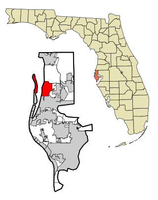
Dunedin is a city in Pinellas County, Florida, United States. The name comes from Dùn Èideann, the Scottish Gaelic name for Edinburgh, the capital of Scotland. Dunedin is part of the Tampa-St. Petersburg-Clearwater metropolitan area and is the fifth largest city in Pinellas County. The population was 36,068 as of the 2020 census.

Indian Rocks Beach, or IRB, is a city in Pinellas County, Florida, United States. The population was 4,286 at the 2018 census. Indian Rocks Beach is part of the Tampa-St. Petersburg-Clearwater, FL Metropolitan Statistical Area. Located on the barrier island Sand Key, it has over two miles of beach along the Gulf of Mexico, with 26 public beach accesses.
St. Pete Beach is a coastal city in Pinellas County, Florida. Known as a tourist destination, St. Pete Beach was formed from the towns of Pass-a-Grille, Belle Vista, St. Petersburg Beach and unincorporated Pinellas County. The population was 9,346 at the 2010 census.

Tarpon Springs is a city in Pinellas County, Florida, United States. The population was 23,484 at the 2010 census. Downtown Tarpon Springs has long been a focal point and is undergoing beautification.

Tierra Verde is a census-designated place (CDP) in Pinellas County, Florida, United States. The population was 3,721 at the 2010 census. The community is located on an island near the entrance of Tampa Bay, and is connected by the bridges of the Pinellas Bayway to both St. Petersburg and St. Pete Beach. At the southern end of Tierra Verde is Fort De Soto, a county park.

Barrier islands are coastal landforms and a type of dune system that are exceptionally flat or lumpy areas of sand that form by wave and tidal action parallel to the mainland coast. They usually occur in chains, consisting of anything from a few islands to more than a dozen. They are subject to change during storms and other action, but absorb energy and protect the coastlines and create areas of protected waters where wetlands may flourish. A barrier chain may extend uninterrupted for over a hundred kilometers, excepting the tidal inlets that separate the islands, the longest and widest being Padre Island of Texas, United States. Sometimes an important inlet may close permanently, transforming an island into a peninsula, thus creating a barrier peninsula, often including a beach, barrier beach. The length and width of barriers and overall morphology of barrier coasts are related to parameters including tidal range, wave energy, sediment supply, sea-level trends, and basement controls. The amount of vegetation on the barrier has a large impact on the height and evolution of the island.

Hurricane Elena was a tropical cyclone that affected eastern and central portions of the United States Gulf Coast in late August and early September 1985. Threatening popular tourist destinations during Labor Day weekend, Elena repeatedly deviated from its forecast path, triggering evacuations of unprecedented extent. The hurricane wrought havoc to property and the environment between southwestern Florida and eastern Louisiana, though lesser effects were felt well beyond those areas. Elena developed on August 28 near Cuba, and after traveling lengthwise across the island with little impact, it entered the Gulf of Mexico and continued to strengthen. Initially projected to strike the central Gulf Coast, the hurricane unexpectedly veered toward the east on August 30, then stalled just 50 mi (80 km) west of Cedar Key, Florida. Despite predictions that Elena would continue eastward across Florida, the cyclone remained nearly stationary for about 48 hours, causing damage all along the eastern gulf with high winds and waves, before slowly moving northwest and ultimately making landfall near Biloxi, Mississippi, on September 2 as a Category 3 major hurricane. The storm quickly weakened upon moving ashore and dissipated on September 4.

Gulf Islands National Seashore offers recreation opportunities and preserves natural and historic resources along the Gulf of Mexico barrier islands of Florida and Mississippi. The protected regions include mainland areas and parts of seven islands. Some islands along the Alabama coast were originally considered for inclusion, but none are part of the National Seashore.

South-southwest of St. Petersburg, Florida, Fort De Soto Park is a park operated by Pinellas County on five offshore keys, or islands: Madelaine Key, St. Jean Key, St. Christopher Key, Bonne Fortune Key and the main island, Mullet Key. The keys are connected by either bridge or causeway. The island group is accessible by toll road from the mainland. Historically, the islands were used for military fortifications; remnants and a museum exhibit this history. Two piers, beaches, picnic area, hiking trails, bicycling trails, kayak trail, and a ferry to Egmont Key State Park are available.
Anclote Key is a barrier island off the Gulf Coast of the U.S. state of Florida, the largest island in the Anclote Keys, located at 28°11′16″N82°50′44″W near Tarpon Springs. Its name originates from the Spanish term for "anchor." The island is accessible only by boat and is split between Anclote Key Preserve State Park and Anclote National Wildlife Reserve. North Anclote Bar, South Anclote Bar, and Three Rooker Island are part of Anclote Key Preserve State Park. The island contains mangrove wetlands, coastal pine flatwoods, and beaches. A large number of shorebirds nest and breed on Anclote Key and the surrounding islands. Sand Key is located nearby. Most of the island is located within Pasco County, while its southernmost section is in Pinellas County. The island is home to the Anclote Keys Light.

Perdido Key is an unincorporated community in Escambia County, Florida located between Pensacola, Florida and Orange Beach, Alabama.The community is located on and named for Perdido Key, a barrier island in northwest Florida and southeast Alabama. "Perdido" means "lost" in the Spanish and Portuguese languages. The Florida district of the Gulf Islands National Seashore includes the east end of the island, as well as other Florida islands. No more than a few hundred yards wide in most places, Perdido Key stretches some 16 miles (26 km) from near Pensacola to Perdido Pass Bridge near Orange Beach.

Treasure Island Causeway is a series of three bridges crossing Boca Ciega Bay between Treasure Island and St. Petersburg in Pinellas County, Florida. The bridge, which carries County Road 150 (CR 150), is owned and maintained by the City of Treasure Island, which used to charge all motorists $1.00 toll, until June, 2006, when the first span of the bridge was reopened with no toll booth. Residents of two St. Petersburg waterfront communities used to pay a $10 annual road tax to the City of Treasure Island to help support road and median maintenance. That tax was eliminated in the spring of 2007. Treasure Island's ownership of the causeway in St. Petersburg was part of a land agreement entered into when these two cities were born: St. Petersburg's founding fathers purchased the Municipal Beach on the shores of the neighboring Gulf of Mexico community, Treasure Island, outside its own city limits to ensure that residents would have direct access to the Gulf of Mexico for generations to come. The western terminus is an intersection with Gulf of Mexico Boulevard in Treasure Island.

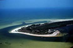
Anclote Key Preserve State Park is a Florida State Park and historic site, located on Anclote Key three miles (5 km) off Tarpon Springs along the Atlantic coastal plain. This state park is only accessible by boat. Amenities include primitive camping on the northern portion of the island as well as picnic pavilions and grills. Wildlife includes the American oystercatcher, bald eagle and piping plover. The park is unique in that a lighthouse, built in 1887, is on the southern end of the key in Pinellas County, Florida. Three Rooker Island, south of Anclote and part of the preserve, remains an important Gulf Coast beach-nesting bird sanctuary.

Egmont Key National Wildlife Refuge and State Park is a National Wildlife Refuge and State Park located on the island of Egmont Key, at the mouth of Tampa Bay. Egmont Key lies southwest of Fort De Soto Park and can only be reached by boat or ferry. Located within Egmont Key National Wildlife Refuge and State Park are the 1858 Egmont Key Lighthouse, maintained by the U.S. Coast Guard, and the ruins of Fort Dade, a Spanish–American War era fort that housed 300 residents. Egmont Key is located in Hillsborough County Florida on a narrow strip of the county that extends along the Tampa Port Shipping Channel.
Mound Key Archaeological State Park is a Florida State Park, located in Estero Bay, near the mouth of the Estero River. One hundred and thirteen of the island's one hundred and twenty-five acres are managed by the park system. It is a complex of mounds and accumulated shell, fish bone, and pottery middens that rises more than 30 feet above the waters of the bay.
Wreck Island Natural Area Preserve is a 1,380-acre (5.6 km2) Natural Area Preserve located in Northampton County, Virginia. One of the Virginia Barrier Islands, it protects various marsh, beach, grassland, dune, and shrubland habitats. It was designated as part of the National Audubon Society's "Barrier Island/Lagoon System Important Bird Area" for its importance as a nursery for nesting bird colonies. The island, which is slowly migrating towards the mainland, formerly featured dune-like mounds of shells which were destroyed by Hurricane Isabel.

Sand Key is a barrier island on Florida's Gulf Coast that stretches from Madeira Beach through Redington Beach, North Redington Beach, Redington Shores, Indian Shores, Indian Rocks Beach, Belleair Shore, and Belleair Beach into Clearwater.

Boca Ciega Bay is a body of water connected to the Gulf of Mexico on the west-central coast of Florida. It is bordered by Gulfport, St. Petersburg, and other municipalities in Pinellas County. Clam Bayou estuary feeds into the bay.
