
Dane County Regional Airport (DCRA), also known as Truax Field, is a civil-military airport located 6 nautical miles northeast of downtown Madison, Wisconsin. In the Federal Aviation Administration (FAA) National Plan of Integrated Airport Systems for 2023–2027, it is one of 2 airports in Wisconsin that is categorized as a small-hub primary commercial service facility; the other is Appleton International Airport. It is the second busiest of eight commercial airports in Wisconsin in terms of passengers served, after Milwaukee Mitchell International Airport.

McNary Field is in Marion County, Oregon, United States, two miles southeast of downtown Salem, which owns it. The airport is named for U.S. Senator Charles L. McNary.
Antrim County Airport is a county-owned public-use airport located one mile (2 km) northeast of the central business district of Bellaire, a village in Antrim County, Michigan, United States. It is included in the Federal Aviation Administration (FAA) National Plan of Integrated Airport Systems for 2017–2021, in which it is categorized as a local general aviation facility.

Westfield-Barnes Regional Airport is a joint civil-military airport in Hampden County, Massachusetts, three miles (6 km) north of Westfield and northwest of Springfield. It was formerly Barnes Municipal Airport; the National Plan of Integrated Airport Systems for 2011–2015 categorized it as a general aviation facility. Westfield-Barnes is one of Massachusetts' largest airports with a strong flight training, general aviation, and military presence. It is also known as Barnes Air National Guard Base.
Turners Falls Airport is a town owned, public use airport located three nautical miles (6 km) north of the central business district of Montague, a town in Franklin County, Massachusetts, United States. It is owned by the Town of Montague. It is included in the National Plan of Integrated Airport Systems for 2011–2015, which categorized it as a general aviation facility.

Greater Portsmouth Regional Airport is on State Route 335 in Minford, Ohio, 12 miles northeast of Portsmouth, in Scioto County, Ohio. It is owned by the Scioto County Airport Authority. The National Plan of Integrated Airport Systems for 2011–2015 categorized it as a general aviation facility.
Frankfort Dow Memorial Field is a public use airport located two nautical miles (3.7 km) southeast of the central business district of Frankfort, a city in Benzie County, Michigan, United States. It is owned by the Frankfort City-County Airport Authority. It is included in the Federal Aviation Administration (FAA) National Plan of Integrated Airport Systems for 2017–2021, in which it is categorized as a general aviation facility.
Gaylord Regional Airport is a county-owned, public-use airport located one nautical mile (2 km) southwest of the central business district of Gaylord, a city in Otsego County, Michigan, United States. It is included in the Federal Aviation Administration (FAA) National Plan of Integrated Airport Systems for 2017–2021, in which it is categorized as a local general aviation facility.

St. Clair County Airport is a public use airport located three nautical miles southeast of the central business district of Pell City, in St. Clair County, Alabama, United States. It is owned by the St. Clair County Airport Authority. According to the FAA's National Plan of Integrated Airport Systems for 2009–2013, it is categorized as a reliever airport for the Birmingham-Shuttlesworth International Airport.
Elfin Cove Seaplane Base is a state-owned public-use seaplane base located in Elfin Cove, on Chichagof Island in the Hoonah-Angoon Census Area of the U.S. state of Alaska. Scheduled airline service is subsidized by the Essential Air Service program.
Pelican Seaplane Base is a public-use seaplane base located in and owned by the City of Pelican, on Chichagof Island in the Hoonah-Angoon Census Area of the U.S. state of Alaska. Scheduled airline service is subsidized by the Essential Air Service program.

Zamperini Field is a public airport three miles (5 km) southwest of downtown Torrance, in Los Angeles County, California, United States.

New Smyrna Beach Municipal Airport, also known as Jack Bolt Field, is a public airport located three miles (5 km) northwest of the central business district of New Smyrna Beach, a city in Volusia County, Florida, United States. It is owned by the City of New Smyrna Beach.
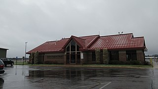
Walker County Airport, also known as Bevill Field, is a public airport located five miles (8 km) northwest of the central business district of Jasper, a city in Walker County, Alabama, United States. It is owned by the Walker County Commission.
Sonoma Skypark is a public-use airport located three nautical miles (6 km) southeast of the central business district of Sonoma, a city in Sonoma County, California, United States. It is privately owned by Sonoma Skypark, Inc.
Cullman Regional Airport-Folsom Field is a public-use airport located five nautical miles north of the central business district of Cullman, a city in Cullman County, Alabama, United States. It is owned by the City and County of Cullman.
Coffman Cove Seaplane Base is a state-owned public-use seaplane base in Coffman Cove, a city in the Prince of Wales-Hyder Census Area on Prince of Wales Island in the U.S. state of Alaska. It is included in the National Plan of Integrated Airport Systems for 2011–2015, which categorized it as a general aviation facility.
Hyder Seaplane Base is a state owned, public use seaplane base located one nautical mile southeast of the central business district of Hyder, a community in the Prince of Wales-Hyder Census Area of the U.S. state of Alaska. It is included in the National Plan of Integrated Airport Systems for 2011–2015, which categorized it as a general aviation facility. It shares its airspace with the nearby Stewart Aerodrome and Stewart Water Aerodrome and its water runway in the Portland Canal exists on the Canada–United States border.

Bowers Field is a county-owned, public-use airport in Kittitas County, Washington, United States. It is located two nautical miles (4 km) north of the central business district of Ellensburg, Washington. This airport is included in the National Plan of Integrated Airport Systems for 2011–2015, which categorized it as a general aviation facility.
Naukati Bay Seaplane Base, formerly known as Nichin Cove Seaplane Base, is a public use seaplane base located at Nichin Cove on the east side of Tuxekan Island, in the Prince of Wales-Hyder Census Area of the U.S. state of Alaska. It is owned by the Naukati Bay Community and located 2 nautical miles (4 km) southwest of Naukati Bay which is on Prince of Wales Island.
