Sherwood, Defiance County, Ohio

Last updated

Sherwood, Ohio
Harrison below Vine, Sherwood.jpg
Harrison Street downtown
OHMap-doton-Sherwood Defiance County.png
Location of Sherwood, Defiance County, Ohio
Map of Defiance County Ohio Highlighting Sherwood Village.png
Location of Sherwood in Defiance County
Coordinates: 41°17′20″N84°33′11″W / 41.28889°N 84.55306°W / 41.28889; -84.55306
Country United States
State Ohio
County Defiance
Area
[1]
  Total1.57 sq mi (4.07 km2)
  Land1.56 sq mi (4.03 km2)
  Water0.01 sq mi (0.04 km2)
Elevation
[2]
705 ft (215 m)
Population
 (2020)
  Total802
  Density514.76/sq mi (198.78/km2)
Time zone UTC-5 (Eastern (EST))
  Summer (DST) UTC-4 (EDT)
ZIP code
43556
Area code 419
FIPS code 39-72256 [3]
GNIS feature ID2399805 [2]

Sherwood is a village in Defiance County, Ohio, United States. The population was 802 at the 2020 census.

Contents

History

Sherwood was platted in the 1870s when the railroad was extended to that point. [4] The village was named for Isaac R. Sherwood, a member of the United States House of Representatives from Ohio. [5]

Geography

According to the United States Census Bureau, the village has a total area of 1.49 square miles (3.86 km2), of which 1.47 square miles (3.81 km2) is land and 0.02 square miles (0.05 km2) is water. [6]

Demographics

Historical population
CensusPop.Note
1880 195
1900 455
1910 56624.4%
1920 543−4.1%
1930 521−4.1%
1940 5546.3%
1950 5702.9%
1960 5781.4%
1970 78435.6%
1980 91516.7%
1990 828−9.5%
2000 801−3.3%
2010 8273.2%
2020 802−3.0%
U.S. Decennial Census [7]

2010 census

As of the census [8] of 2010, there were 827 people, 327 households, and 226 families residing in the village. The population density was 562.6 inhabitants per square mile (217.2/km2). There were 356 housing units at an average density of 242.2 per square mile (93.5/km2). The racial makeup of the village was 96.7% White, 0.4% African American, 0.2% Native American, 0.1% Asian, 0.8% from other races, and 1.7% from two or more races. Hispanic or Latino of any race were 4.8% of the population.

There were 327 households, of which 35.5% had children under the age of 18 living with them, 50.8% were married couples living together, 12.8% had a female householder with no husband present, 5.5% had a male householder with no wife present, and 30.9% were non-families. 26.9% of all households were made up of individuals, and 13.2% had someone living alone who was 65 years of age or older. The average household size was 2.53 and the average family size was 3.04.

The median age in the village was 36 years. 28.4% of residents were under the age of 18; 6.6% were between the ages of 18 and 24; 25.7% were from 25 to 44; 23.8% were from 45 to 64; and 15.6% were 65 years of age or older. The gender makeup of the village was 46.9% male and 53.1% female.

2000 census

As of the census [3] of 2000, there were 801 people, 301 households, and 227 families residing in the village. The population density was 554.4 inhabitants per square mile (214.1/km2). There were 315 housing units at an average density of 218.0 per square mile (84.2/km2). The racial makeup of the village was 96.00% White, 0.75% African American, 0.37% Native American, 1.87% from other races, and 1.00% from two or more races. Hispanic or Latino of any race were 3.50% of the population.

There were 301 households, out of which 34.6% had children under the age of 18 living with them, 60.8% were married couples living together, 10.3% had a female householder with no husband present, and 24.3% were non-families. 21.3% of all households were made up of individuals, and 9.6% had someone living alone who was 65 years of age or older. The average household size was 2.66 and the average family size was 3.04.

In the village, the population was spread out, with 27.3% under the age of 18, 8.5% from 18 to 24, 29.5% from 25 to 44, 22.2% from 45 to 64, and 12.5% who were 65 years of age or older. The median age was 36 years. For every 100 females there were 89.8 males. For every 100 females age 18 and over, there were 90.8 males.

The median income for a household in the village was $39,135, and the median income for a family was $42,188. Males had a median income of $32,130 versus $23,500 for females. The per capita income for the village was $16,212. About 10.9% of families and 12.5% of the population were below the poverty line, including 14.7% of those under age 18 and 17.3% of those age 65 or over.

Education

Sherwood has a public library, a branch of the Defiance Public Library System. [9]

Related Research Articles

<span class="mw-page-title-main">Defiance County, Ohio</span> County in Ohio, United States

Defiance County is a county located in the U.S. state of Ohio. As of the 2020 census, the population was 38,286. Its county seat and largest city is Defiance. The county was named after an early Army fortification, Fort Defiance, which was so named by Mad Anthony Wayne to signify the settlers' "defiance" of the Indians. The Defiance, OH Micropolitan Statistical Area includes all of Defiance County.

<span class="mw-page-title-main">Sherwood Manor, Connecticut</span> Census-designated place in Connecticut, United States

Sherwood Manor is a census-designated place (CDP) within the town of Enfield in Hartford County, Connecticut, United States. The population was 5,410 at the 2010 census.

<span class="mw-page-title-main">Defiance, Iowa</span> City in Iowa, United States

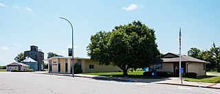
Defiance is a city in Shelby County, Iowa, United States, along the West Branch of the West Nishnabotna River. The population was 245 at the time of the 2020 census.

<span class="mw-page-title-main">Sherwood Township, Michigan</span> Civil township in Michigan, United States

Sherwood Township is a civil township of Branch County in the U.S. state of Michigan. The population was 1,959 at the 2020 census.

<span class="mw-page-title-main">Creighton, Missouri</span> City in Missouri, United States

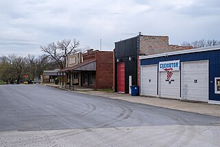
Creighton is a city in Cass County, Missouri, United States. The population was 327 at the 2020 census. It is 57 miles south southeast of the Kansas City metropolitan area.

<span class="mw-page-title-main">Sycamore Hills, Missouri</span> Village in Missouri, United States

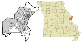
Sycamore Hills is a village in St. Louis County, Missouri, United States. The population is 560 at the 2020 census.

<span class="mw-page-title-main">Wilbur Park, Missouri</span> Village in Missouri, United States

Wilbur Park is a village in St. Louis County, Missouri, United States. The population was 439 at the 2020 census.

<span class="mw-page-title-main">Hanley Hills, Missouri</span> Village in Missouri, United States

Hanley Hills is a village in St. Louis County, Missouri, United States. The population was 2,101 at the 2010 census.

<span class="mw-page-title-main">Hicksville, Ohio</span> Village in Ohio, United States

Hicksville is a village in Defiance County, Ohio, United States. The population was 3,431 at the 2020 census. It sits approximately 2.2 miles east of the Ohio-Indiana border.

<span class="mw-page-title-main">Ney, Ohio</span> Village in Ohio, United States

Ney is a village in Defiance County, Ohio, United States. The population was 303 at the 2020 census. Ney has been noted for having one of the shortest place names in Ohio.

<span class="mw-page-title-main">Addyston, Ohio</span> Village in Ohio, United States

Addyston is a village in Miami Township, Hamilton County, Ohio, United States. Located along the Ohio River, it is a western suburb of the neighboring city of Cincinnati. The population was 927 at the 2020 census.

<span class="mw-page-title-main">Sherwood, Hamilton County, Ohio</span> Census-designated place in Ohio, United States

Sherwood is a census-designated place (CDP) in Hamilton County, Ohio, United States. The population was 3,633 at the 2020 census.

<span class="mw-page-title-main">Holgate, Ohio</span> Village in Ohio, United States

Holgate is a village in Henry County, Ohio, United States. The population was 1,061 at the 2020 census.

<span class="mw-page-title-main">Camden, Ohio</span> Village in Ohio, United States

Camden is a village in Preble County, Ohio, United States. The population was 1,989 at the 2020 census.

<span class="mw-page-title-main">Hartville, Ohio</span> Village in Ohio, United States

Hartville is a village in northern Stark County, Ohio, United States. The population was 3,329 at the 2020 census. It is part of the Canton–Massillon metropolitan area. Hartville lies halfway between Akron and Canton at the intersection of State Routes 43 and 619.

<span class="mw-page-title-main">Bellevue, Wisconsin</span> Village in Wisconsin, United States

Bellevue is a village in Brown County, Wisconsin. It was a town until incorporating as a village on February 14, 2003. The population was 15,935 at the time of the 2020 census. Bellevue is part of the Green Bay metropolitan area. Bellevue sits around 4.34 miles (6.99 km) east from central Green Bay.

<span class="mw-page-title-main">Sherwood, Wisconsin</span> Village in Wisconsin, United States

Sherwood is a village in Calumet County, Wisconsin, United States. The population was 2,713 at the 2010 census. The former historical unincorporated community of High Cliff is located within present-day Sherwood.

Sherwood is a town in Clark County in the U.S. state of Wisconsin. The population was 252 at the 2000 census. The unincorporated community of Nevins is located in the town.

<span class="mw-page-title-main">Avoca, Wisconsin</span> Village in Wisconsin, United States

Avoca is a village in Iowa County, Wisconsin, United States. The population was 637 at the 2010 census. It is part of the Madison Metropolitan Statistical Area. It is named after Avoca in Ireland.

<span class="mw-page-title-main">Dorchester, Wisconsin</span> Village in Wisconsin, United States

Dorchester is a village in Clark and Marathon counties in the U.S. state of Wisconsin, along the 45th parallel. It is part of the Wausau, Wisconsin Metropolitan Statistical Area. The population was 876 at the 2010 census. Of this, 871 were in Clark County, and only 5 were in Marathon County.

References

  1. "ArcGIS REST Services Directory". United States Census Bureau. Retrieved September 20, 2022.
  2. 1 2 U.S. Geological Survey Geographic Names Information System: Sherwood, Defiance County, Ohio
  3. 1 2 "U.S. Census website". United States Census Bureau . Retrieved January 31, 2008.
  4. Allison, Don (July 19, 1990). "Sherwood named after local Civil War general". The Bryan Times. p. 11. Retrieved May 2, 2015.
  5. Overman, William Daniel (1958). Ohio Town Names. Akron, OH: Atlantic Press. p. 126.
  6. "US Gazetteer files 2010". United States Census Bureau. Archived from the original on January 25, 2012. Retrieved January 6, 2013.
  7. "Census of Population and Housing". Census.gov. Retrieved June 4, 2015.
  8. "U.S. Census website". United States Census Bureau . Retrieved January 6, 2013.
  9. "Locations". Defiance Public Library System. Retrieved February 25, 2018.