Shiel Bridge

Last updated

Shiel Bridge
Highland UK location map.svg
Red pog.svg
Shiel Bridge
Location within the Highland council area
OS grid reference NG937188
Council area
Country Scotland
Sovereign state United Kingdom
Postcode district IV40 8
Police Scotland
Fire Scottish
Ambulance Scottish
List of places
UK
Scotland
57°12′50″N5°25′00″W / 57.21382°N 5.41678°W / 57.21382; -5.41678

Shiel Bridge is a hamlet on the south east shore of Loch Duich at the foot of Glen Shiel, in the Lochalsh area of the Scottish Highlands. It is in the council area of Highland.

Contents

Geography

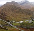
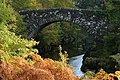
To the east of the hamlet, the River Shiel empties into the small Loch Shiel. The river then continues east, under the old bridge over the river (from where the hamlet derives its name), until it empties in Loch Duich.

The River Shiel, before it arrives at Shiel Bridge, is joined by a tributary river, the Allt Undalain, which flows down the eastern side of Sgùrr Mhic Bharraich.

The hamlet of Ratagan is 1 mile (2 kilometres) south east of the hamet. The A87 road passes through the hamlet, continuing on along the north coast of Loch Duich, passing Dornie, Nostie and Kirkton on to Kyle of Lochalsh.

Over the original Shiel Bridge is an old military road (the C1123) that is known as the Bealach Ratagain, connecting the communities of Ratagan, Glenelg, Arnisdale, Letterfearn and Corran to the A87.

Due to the surrounding mountains and forests, Shiel Bridge is a popular site for hillwalkers, accessible via bus from both Kyle of Lochalsh and Inverness. Both the Cape Wrath and Knoydart Trails pass through the village, the latter leading to Suardalan bothy [1] if followed south and west.

History

Nearby, the Battle of Glenshiel took place in 1719, where Jacobites, supported by around 300 Spanish troops, fought a government army loyal to King George I. Despite their superior numbers, the Jacobites lost.

Facilities

The hamlet has few amenities, but includes a caravan park & campsite, [2] and pony tours. [3] Recently, a small filling station has been converted into a coffee shop and handmade chocolate factory.

Just south of the village are the Five Sisters of Kintail, a sub-range of the Western Highlands containing three Munros (Sgùrr na Ciste Duibhe, Sgùrr na Càrnach, and Sgùrr Fhuaran). Golden eagles, red deer, and wild goats are among some of the area's native species. [4]

Related Research Articles

<span class="mw-page-title-main">Ross, Scotland</span>

Ross is a region of Scotland. One of the provinces of Scotland from the 9th century, it gave its name to a later earldom and to the counties of Ross-shire and, later, Ross and Cromarty. The name Ross allegedly derives from a Gaelic word meaning "headland", perhaps a reference to the Black Isle. Another possible origin is the West Norse word for Orkney – Hrossey – meaning horse island; the area once belonged to the Norwegian earldom of Orkney. Ross is a historical comital region, perhaps predating the Mormaerdom of Ross. It is also a region used by the Kirk, with the Presbytery of Ross being part of the Synod of Ross, Sutherland and Caithness.

<span class="mw-page-title-main">A87 road</span> Major road through the Highland region of Scotland

The A87 is a major road in the Highland region of Scotland.

<span class="mw-page-title-main">Loch Shiel</span> Freshwater loch in Scotland

Loch Shiel is a freshwater loch situated 20 kilometres (12 mi) west of Fort William in the Highland council area of Scotland. At 28 kilometres long it is the 4th longest loch in Scotland, and is the longest to have retained a natural outflow without any regulation of its water level, being 120 m (393 ft) deep. Its nature changes considerably along its length, being deep and enclosed by mountains in the north east and shallow surrounded by bog and rough pasture in the south west, from which end the 4 km River Shiel drains to the sea in Loch Moidart near Castle Tioram.

<span class="mw-page-title-main">Glenelg, Highland</span> Human settlement in Scotland

Glenelg (Scottish Gaelic: Glinn Eilg, also Gleann Eilg is a scattered community area and civil parish in the Lochalsh area of Highland in western Scotland. Despite the local government reorganisation the area is considered by many still to be in Inverness-shire, the boundary with Ross-shire being at the top of Mam Ratagan the single-track road entry into Glenelg.

<span class="mw-page-title-main">Dornie</span> Village in Kintail, Ross-shire, Scotland

Dornie is a small former fishing village in the Lochalsh district in western Ross-shire Highlands of Scotland. It is near the meeting point of Loch Duich, Loch Alsh and Loch Long.

<span class="mw-page-title-main">Sgùrr na Sgine</span>

Sgùrr na Sgine is a mountain in the Northwest Highlands of Scotland. Its height is 946 metres (3,104 ft), making it a Munro. It lies eight kilometres south of Shiel Bridge in the Glenshiel Forest, between Glen Shiel and Loch Hourn.

<span class="mw-page-title-main">Sgùrr Fhuaran</span>

Sgùrr Fhuaran is a Scottish mountain that is situated on the northern side of Glen Shiel, 23 kilometres (14 mi) east south east of Kyle of Lochalsh.

<span class="mw-page-title-main">Sgùrr na Càrnach</span>

Sgùrr na Càrnach is a mountain in the Northwest Highlands of Scotland, one of the 'Five Sisters of Kintail'. It is on the northern side of Glen Shiel, 24 kilometres southeast of Kyle of Lochalsh. It reaches a height of 1,002 metres (3,287 ft) and is classed as a Munro. The summit is rough and boulder-ridden, living up to its Gaelic name which means "peak of the stony place".

<span class="mw-page-title-main">Sgùrr na Ciste Duibhe</span> Mountain in the Scottish Highlands

Sgùrr na Ciste Duibhe or Sgùrr nan Cisteachan Dubha is a mountain in the Northwest Highlands of Scotland, one of the 'Five Sisters of Kintail'. It is on the northern side of Glen Shiel, 27 kilometers southeast of Kyle of Lochalsh. Its height is 1,027 metres (3,369 ft) and it is classed as a Munro.

<span class="mw-page-title-main">Kintail</span>

Kintail is a mountainous area sitting at the head of Loch Duich in the Northwest Highlands of Scotland, located in the Highland Council area.

<span class="mw-page-title-main">Aonach Meadhoin</span> Mountain in Scotland

Aonach Meadhoin is a Munro mountain situated in the Kintail region of Scotland. It stands on the northern side of Glen Shiel some 31 kilometres south east of Kyle of Lochalsh.

<span class="mw-page-title-main">Sgùrr a' Bhealaich Dheirg</span>

Sgùrr a' Bhealaich Dheirg is a mountain in Kintail on the northern side of Glen Shiel in the Scottish Highlands. With a height of 1,036 metres (3,399 ft), it is classed as a Munro. It is the highest of three Munros known as the "Brothers of Kintail" in contrast to the Five Sisters of Kintail which lie just to the west.

<span class="mw-page-title-main">Ardelve</span> Human settlement in Scotland

Ardelve is a village in Highland, Scotland, on Loch Alsh. It overlooks the Eilean Donan Castle, which is in Dornie, also on Loch Alsh, to the east of Skye. A caravan park, several guest houses, a bakery, and pizzeria are located within Ardelve.

<span class="mw-page-title-main">Loch Alsh</span> Sea inlet of Scotland, UK

Loch Alsh is a sea inlet between the isle of Skye in the Inner Hebrides and the Northwest Highlands of Scotland. The name is also used to describe the surrounding country and the feudal holdings around the loch. The area is rich in history, and is increasingly popular with tourists.

<span class="mw-page-title-main">Glen Shiel</span> Human settlement in Scotland

Glen Shiel is a glen in the Northwest Highlands of Scotland.

<span class="mw-page-title-main">Nostie</span> Human settlement and power station in Scotland

Nostie is a small remote hamlet, lying on Nostie Bay, an inlet at the northeastern end of the sea loch, Loch Alsh in the Scottish Highlands and is in the council area of Highland. Nostie lies a short distance from one of Scotland's popular tourist attractions, Eilean Donan Castle.

Ratagan is a small hamlet on the southwestern shore of the sea loch, Loch Duich in Lochalsh, Scottish Highlands and is in the Scottish council area of Highland.

<span class="mw-page-title-main">Morvich, Highland</span> Human settlement in Scotland

Morvich is a settlement in Glen Shiel near the southern end of Loch Duich, and to the north of Kintail, in Lochalsh, in the Highland council area of Scotland. The name "Morvich" may be from the Gaelic for "sea plain" or "the carse".

<span class="mw-page-title-main">Lochalsh</span>

Lochalsh is a district of mainland Scotland that is currently part of the Highland council area. The Lochalsh district covers all of the mainland either side of Loch Alsh - and of Loch Duich - between Loch Carron and Loch Hourn, ie. from Stromeferry in the north on Loch Carron down to Corran on Loch Hourn and as (south-)west as Kintail. It was sometimes more narrowly defined as just being the hilly peninsula that lies between Loch Carron and Loch Alsh. The main settlement is Kyle of Lochalsh, located at the entrance to Loch Alsh, opposite the village of Kyleakin on the adjacent island of Skye. A ferry used to connect the two settlements but was replaced by the Skye Bridge in 1995.

<span class="mw-page-title-main">Erbusaig Bay</span>

Erbusaig Bay is a remote coastal embayment, on a 266° orientation, located on the west coast of the Lochalsh peninsula, in Ross and Cromarty in Scottish Highlands in the west coast of Scotland. At the western side of Erbusaig Bay is the small township of Erbusaig.

References

  1. "Bothy: Suardalan". Mountain Bothies Association . Archived from the original on 14 September 2017.
  2. "Shielbridge Caravan Park & Campsite Home". shielbridgecaravanpark.co.uk. Retrieved 26 July 2020.
  3. "Highland Pony Trekking". www.highlandponytrekking.co.uk. Archived from the original on 27 May 2022. Retrieved 23 June 2023.
  4. "Shiel Bridge". AboutBritain.com. Retrieved 26 July 2020.