
Kangchenjunga, also spelled Kanchenjunga, Kanchanjanghā and Khangchendzonga, is the third-highest mountain in the world. Its summit lies at 8,586 m (28,169 ft) in a section of the Himalayas, the Kangchenjunga Himal, which is bounded in the west by the Tamur River, in the north by the Lhonak River and Jongsang La, and in the east by the Teesta River. It lies in the border region between Nepal and Sikkim state of India, with three of the five peaks, namely Main, Central and South, directly on the border, and the peaks West and Kangbachen in Nepal's Taplejung District.

The red panda, also known as the lesser panda, is a small mammal native to the eastern Himalayas and southwestern China. It has dense reddish-brown fur with a black belly and legs, white-lined ears, a mostly white muzzle and a ringed tail. Its head-to-body length is 51–63.5 cm (20.1–25.0 in) with a 28–48.5 cm (11.0–19.1 in) tail, and it weighs between 3.2 and 15 kg. It is well adapted to climbing due to its flexible joints and curved semi-retractile claws.

The Himalayas, or Himalaya, is a mountain range in Asia, separating the plains of the Indian subcontinent from the Tibetan Plateau. The range has some of the Earth's highest peaks, including the highest, Mount Everest; more than 100 peaks exceeding elevations of 7,200 m (23,600 ft) above sea level lie in the Himalayas.
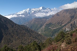
Sagarmāthā National Park is a national park in the Himalayas of eastern Nepal that is dominated by Mount Everest. It was established as a National Park in 1976. It encompasses an area of 1,148 km2 (443 sq mi) in the Solukhumbu District and ranges in elevation from 2,845 to 8,848 m at the summit of Mount Everest. In the north, it shares the international border with Qomolangma National Nature Preserve in Tibet Autonomous Region. In the east, it is adjacent to Makalu Barun National Park, and in the south it extends to Dudh Kosi river. It is part of the Sacred Himalayan Landscape.
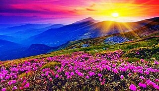
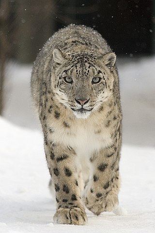
Valley of Flowers National Park is an Indian national park which was established in 1982. It is located in Chamoli in the state of Uttarakhand and is known for its meadows of endemic alpine flowers and the variety of flora. This richly diverse area is also home to rare and endangered animals, including the Asiatic black bear, snow leopard, musk deer, brown bear, red fox and blue sheep. Birds found in the park include Himalayan monal pheasant and other high altitude birds.
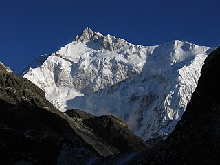
Khangchendzonga National Park, also Kanchenjunga Biosphere Reserve, is a national park and a biosphere reserve located in Sikkim, India. It was inscribed to the UNESCO World Heritage Sites list in July 2016, becoming the first "Mixed Heritage" site of India. It was included in the UNESCO Man and the Biosphere Programme. The park is named after the mountain Kangchenjunga, which is the third-highest peak in the world at 8,586 m (28,169 ft) tall. The total area of the park is 849.5 km2 (328.0 sq mi).

Makalu Barun National Park is a national park in the Himalayas of Nepal that was established in 1992 as the eastern extension of Sagarmatha National Park. It is the world's only protected area with an elevation gain of more than 8,000 m (26,000 ft) enclosing tropical forest as well as snow-capped peaks. It covers an area of 1,500 km2 (580 sq mi) in the Solukhumbu and Sankhuwasabha districts, and is surrounded by a bufferzone to the south and southeast with an area of 830 km2 (320 sq mi).

The Himalayan subtropical broadleaf forests is an ecoregion that extends from the middle hills of central Nepal through Darjeeling into Bhutan and also into the Indian States of Uttar Pradesh and Bihar. It represents the east–west-directed band of subtropical broadleaf forest at an altitude of between 500 and 1,000 m along the Outer Himalayan Range, and includes several forest types traversing an east to west moisture gradient.
Kyongnosla Alpine Sanctuary is a nature reserve in Gangtok district, Sikkim, India. It is situated around the area adjoining the Tsomgo (Changu) lake along the Nathula Road. Located about 31 km (19 mi) east of Gangtok, the capital of Sikkim, this sanctuary covers an area of about 31 km2 (12 sq mi), and extends from the "15th Mile" police check point up to and along the ridges bordering the Rong Chu Valley and Lake Tsomgo.

The Eastern Himalayan broadleaf forests is a temperate broadleaf forest ecoregion found in the middle elevations of the eastern Himalayas, including parts of Nepal, India, Bhutan, Myanmar and China. These forests have an outstanding richness of wildlife.
India is home to a large variety of wildlife. It is a biodiversity hotspot with various ecosystems ranging from the Himalayas in the north to the evergreen rain forests in the south, the sands of the west to the marshy mangroves of the east. India lies within the Indomalayan realm and is the home to about 7.6% of mammal, 14.7% of amphibian, 6% of bird, 6.2% of reptilian, and 6.2% of flowering plant species. India's forests contain about 500 species of mammals and more than 1300 bird species.
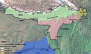
The Eastern Himalayas extend from eastern Nepal across Northeast India, Bhutan, the Tibet Autonomous Region to Yunnan in China and northern Myanmar. The climate of this region is influenced by the monsoon of South Asia from June to September. It is a biodiversity hotspot, with notable biocultural diversity.

Langtang National Park is a national protected area in north-central Nepal. It was established in 1976 as Nepal's first Himalayan national park and the country's fourth protected area. It covers an area of 1,710 km2 (660 sq mi) in the Nuwakot, Rasuwa and Sindhulpalchok Districts of the central Himalayan region. It contains 26 village communities and includes the Langtang valley. In the north and east it is linked with Qomolangma National Nature Preserve in the Tibet Autonomous Region. The eastern and western boundaries follow the Bhote Koshi and the Trishuli river, respectively.
Hkakaborazi National Park is a national park in northern Myanmar with an area of 1,472 sq mi (3,810 km2). It was established in 1998. It surrounds Hkakabo Razi, the highest mountain in the country. It ranges in elevation from 2,950 to 18,730 ft comprising evergreen forest and mixed deciduous forests in Nogmung Township, Kachin State. It is managed by the Nature and Wildlife Conservation Division. It is contiguous with Bumhpa Bum Wildlife Sanctuary and Hukaung Valley Wildlife Sanctuary. These protected areas together with Hponkanrazi Wildlife Sanctuary comprise the largest continuous expanse of natural forest called the Northern Forest Complex stretching over an area of 11,624 sq mi (30,110 km2). Its objective is to conserve the biodiversity of the Ayeyarwady and Chindwin river basins.

Kanchenjunga Conservation Area is a protected area in the Himalayas of eastern Nepal that was established in 1997. It covers 2,035 km2 (786 sq mi) in the Taplejung District and comprises two peaks of Kanchenjunga. In the north it adjoins the Qomolangma National Nature Preserve in Tibet, and in the east the Khangchendzonga National Park in Sikkim. To the west it borders the Sankhuwasabha District. It ranges in elevation from 1,200 to 8,586 m. It is part of the Sacred Himalayan Landscape, which is being developed by WWF Nepal in partnership with the International Centre for Integrated Mountain Development.

Chandra Prakash Kala is an Indian ecologist and professor. His research interests include alpine ecology, conservation biology, indigenous knowledge systems, ethnobotany and medicinal aromatic plants. He is an assistant professor in the faculty area of Ecosystem and Environment Management at the Indian Institute of Forest Management.

Biogeographic classification of India is the division of India according to biogeographic characteristics. Biogeography is the study of the distribution of species (biology), organisms, and ecosystems in geographic space and through geological time. India has a rich heritage of natural diversity. India ranks fourth in Asia and tenth in the world amongst the top 17 mega-diverse countries in the world. India harbours nearly 11% of the world's floral diversity comprising over 17500 documented flowering plants, 6200 endemic species, 7500 medicinal plants and 246 globally threatened species in only 2.4% of world's land area. India is also home to four biodiversity hotspots—Andaman & Nicobar Islands, Eastern Himalaya, Indo-Burma region, and the Western Ghats. Hence the importance of biogeographical study of India's natural heritage.
The Sacred Himalayan Landscape is a 39,021 km2 (15,066 sq mi) large trans-boundary landscape in the eastern Himalayas encompassing temperate broadleaf and conifer forests, alpine meadows and grasslands, which harbour more than 80 mammal and more than 440 bird species. It extends from Nepal's Langtang National Park through Sikkim and Darjeeling in India to western Bhutan's Torsa Strict Nature Reserve. More than 73% of this landscape is located in Nepal, including Sagarmatha National Park, Makalu Barun National Park, and Kanchenjunga Conservation Area. About 24% is located in India, encompassing Khangchendzonga, Singalila and Neora Valley National Parks as well as Fambong Lho, Maenam, Senchal, Mahananda Wildlife Sanctuaries, Shingba and Barsey Rhododendron Sanctuaries and Kyongnosla Alpine Sanctuary.
Pangolakha Wildlife Sanctuary is a wildlife reserve in the Pakyong District of the state of Sikkim in India. It is about 28 kilometres (17 mi) east of Rorathang and about 40 kilometres (25 mi) by road from Rangpo city. The total notified area of the park is around 124 square kilometres (48 sq mi) while inside the wildlife sanctuary there are a few hamlets: Aritar, Dakline Lingtam, Phadamchen, Dzuluk, Gnathang Monastery Kupup. This wildlife sanctuary is linked to the forests of Neora Valley National Park of West Bengal as well as forests of Samtse, Bhutan and Haa district Bhutan. The area that comes under this biosphere has been declared in 1999 as a wildlife sanctuary under biogeographic province category 2C.

Rhododendron dalhousiae, also known as Lady Dalhousie's rhododendron, is a species of rhododendron first identified in the Eastern Himalayas by Joseph Dalton Hooker during his 1848-1850 expeditions to what is now Sikkim. It is an epiphyte, normally found on tree, cliffs, and boulders, in the lower parts of the Himalayas at altitudes between 5,000 and 9,000 feet. Since its first identification by Hooker, it has been found throughout the southern border of Tibet, Bhutan, Nepal, and northeastern India, particularly in Arunachal Pradesh.
