
Aberdeen is a city in North East Scotland, and is the third most populous Scottish city. Historically, Aberdeen was within the historic county of Aberdeenshire, but is now separate from the council area of Aberdeenshire.

Kirkwall is the largest town in Orkney, an archipelago to the north of mainland Scotland. First mentioned in the Orkneyinga saga, it is today the location of the headquarters of the Orkney Islands Council and a transport hub with ferries to many locations. It is the centre of the St Magnus International Festival and is also a popular stopping off point for cruise ships. St Magnus Cathedral stands at the heart of the town.

Central, also known as Central District, is the central business district of Hong Kong. It is located in the northeastern corner of the Central and Western District, on the north shore of Hong Kong Island, across Victoria Harbour from Tsim Sha Tsui, the southernmost point of Kowloon Peninsula. The area was the heart of Victoria City, although that name is rarely used today.

Harbourfront is a neighbourhood on the northern shore of Lake Ontario within downtown Toronto, Ontario, Canada. Part of the Toronto waterfront, Harbourfront extends from Bathurst Street in the west, along Queens Quay, with its ill-defined eastern boundary being either Yonge Street or York Street. Its northern boundary is the Gardiner Expressway. Much of the district was former water lots filled in during the early 1900s to create a larger harbour district. After shipping patterns changed and the use of the Toronto Harbour declined, the area was converted from industrial uses to a mixed-use district that is mostly residential and leisure.

The Music Hall is a concert hall in Aberdeen, Scotland, formerly the city's Assembly Rooms, located on Union Street in the city centre.

Tourism in Sydney forms an important part of the city's economy. The city received 12 million domestic visitors and 4.1 million international visitors in year ending June 2019. The most famous attractions include the Sydney Opera House, and the Sydney Harbour Bridge. Other attractions include the Sydney Mardi Gras, Royal Botanical Gardens, Luna Park, the beaches and Sydney Tower.
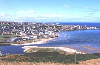
Banff is a town in the Banff and Buchan area of Aberdeenshire, Scotland. It is situated on Banff Bay and faces the town of Macduff across the estuary of the River Deveron. It is a former royal burgh, and is the county town of the historic county of Banffshire.

Aberdeen Maritime Museum is a maritime museum in Aberdeen, Scotland.

Queen's Cross is an area in the West End of Aberdeen, Scotland. It is located just west of the main thoroughfare of Union Street and about 1.5 miles (2.4 km) from the geographical town centre at Mercat Cross.

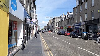
Union Street is a major street and shopping thoroughfare in Aberdeen, Scotland. It is named after the Acts of Union 1800 with Ireland.

The network of transportation in Aberdeen is extensive and diversified, like that of many comparably sized cities.
The architecture of Aberdeen, Scotland, is known for the use of granite as the principal construction material. The stone, which has been quarried in and around the city, has given Aberdeen the epithet The Granite City, or more romantically, and less commonly used, the Silver City, after the mica in the stone which sparkles in the sun.

Castlegate is a small area of Aberdeen, Scotland, located centrally at the east end of the city's main thoroughfare Union Street. Generally speaking, locals consider it to encompass the square at the end of Union Street where the Mercat Cross and Gallowgate are located.
George Street is a street in the city of Aberdeen, Scotland.
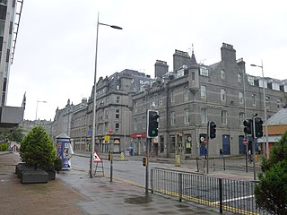
Guild Street is a main street in the city centre of Aberdeen, Scotland, close to the harbour.

Aberdeen Harbour, rebranded as the Port of Aberdeen in 2022, is a sea port located in the city of Aberdeen on the east coast of Scotland. The port was first established in 1136 and has been continually redeveloped over the centuries to provide a base for significant fishing and ship building industries. Since the 1970s it has provided support to the offshore oil and gas industry operating in the North Sea and it is the main commercial port in the north east of Scotland.
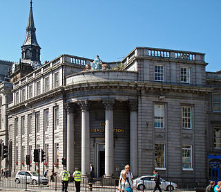
The Society of Advocates in Aberdeen is professional body of legal practitioners based in the city of Aberdeen, Scotland, and its surrounding area.

The Water Lanes were three medieval streets in the city of York in the north of England. They led from Castlegate road down to the waterfront of the River Ouse. The Lanes were similar in appearance to the Shambles with the jettied buildings hanging over the street. In the 19th century, they were known as the First Lane, Middle Lane and Far Water Lane, although in medieval times they had been known as Kergate, Thrush Lane and Hertergate. They were demolished in 1852.
New Aberdeen is a neighbourhood in Aberdeen, Scotland.


