Related Research Articles

The Sierra Nevada is a mountain range in the Western United States, between the Central Valley of California and the Great Basin. The vast majority of the range lies in the state of California, although the Carson Range spur lies primarily in Nevada. The Sierra Nevada is part of the American Cordillera, an almost continuous chain of mountain ranges that forms the western "backbone" of the Americas.
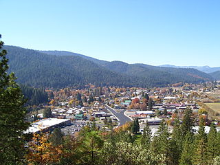
Quincy is a census-designated place and the county seat of Plumas County, California. The population was 1,630 during the 2020 Census, down from 1,728 during the 2010 Census, and 1,879 during the 2000 Census.

The Feather River is the principal tributary of the Sacramento River, in the Sacramento Valley of Northern California. The river's main stem is about 73 miles (117 km) long. Its length to its most distant headwater tributary is just over 210 miles (340 km). The main stem Feather River begins in Lake Oroville, where its four long tributary forks join—the South Fork, Middle Fork, North Fork, and West Branch Feather Rivers. These and other tributaries drain part of the northern Sierra Nevada, and the extreme southern Cascades, as well as a small portion of the Sacramento Valley. The total drainage basin is about 6,200 square miles (16,000 km2), with approximately 3,604 square miles (9,330 km2) above Lake Oroville.
The Nevadan orogeny occurred along the western margin of North America during the Late Jurassic to Early Cretaceous approximately 155 Ma to 145 Ma. Throughout the duration of this orogeny there were at least two different kinds of orogenic processes occurring. During the early stages of orogenesis an "Andean type" continental magmatic arc developed due to subduction of the Farallon oceanic plate beneath the North American Plate. The latter stages of orogenesis, in contrast, saw multiple oceanic arc terranes accreted onto the western margin of North America in a "Cordilleran type" accretionary orogen. Deformation related to the accretion of these volcanic arc terranes is mostly limited to the western regions of the resulting mountain ranges and is absent from the eastern regions. In addition, the deformation experienced in these mountain ranges is mostly due to the Nevadan orogeny and not other external events such as the more recent Sevier and Laramide Orogenies. It is noted that the Klamath Mountains and the Sierra Nevada share similar stratigraphy indicating that they were both formed by the Nevadan orogeny. In comparison with other orogenic events, it appears that the Nevadan Orogeny occurred rather quickly taking only about 10 million years as compared to hundreds of millions of years for other orogenies around the world.

Joseph Nisbet LeConte was an American explorer of the Sierra Nevada. He was also a cartographer, a photographer and a professor of mechanical engineering.

California Cavern is a Limestone cave in the Sierra Nevada foothills, in Cave City, Calaveras County, California.
Fourth Crossing is an unincorporated community in Calaveras County, California. It lies at an elevation of 922 feet and is located on State Route 49 at 38°07′53″N120°38′05″W. The community is in ZIP code 95248 and area code 209.

The North American Cordillera, sometimes also called the Western Cordillera of North America, the Western Cordillera, or the Pacific Cordillera, is the North American portion of the American Cordillera, the mountain chain system (cordillera) along the western coast of the Americas. The North American Cordillera covers an extensive area of mountain ranges, intermontane basins, and plateaus in Western and Northwestern Canada, Western United States, and Mexico, including much of the territory west of the Great Plains.
Echo Lake is a small unincorporated community in El Dorado County, California, United States, along U.S. Route 50 in the mountains of the Sierra Nevada. It is 1.5 miles (2.4 km) north-northwest of Echo Summit. Echo Lake's nearest neighboring town is Little Norway. The ZIP code is 95721. The community is inside area code 530. The elevation of Echo Lake is 7539 feet. The average snowpack per year is 10.5 feet, with over 15 feet of snow depositing in certain areas. Precipitation and accumulation at Echo Lake can be found in California Data Exchange Center stations located at Echo Peak (EP5) and Echo Summit (ECS).
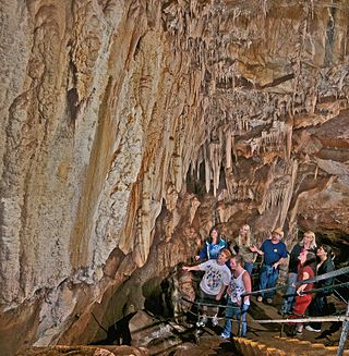
Mercer Caverns is a show cave located one mile north of Murphys in Calaveras County California. It is named after the gold prospector Walter J. Mercer who discovered the caves around 1885 and filed a claim. The caverns have a large number of speleothems, stalactites, and stalagmites. It is formed in a marble unit known as the Calaveras Formation. It also contains a large display of aragonite frostwork. The standard tour of the cave descends 160 feet, 208 steps down and 232 up in a traverse between the natural and an artificial entrance. The cave was mapped in 1986 to a length of 3389 feet and a total depth of 192 feet. The map can be viewed on the cave's web site.

Sierra Foothills is a vast American Viticultural Area (AVA) encompassing the foothill "belt" of the Sierra Nevada in north-central California, United States. It was established on December 18, 1987 by the Bureau of Alcohol, Tobacco and Firearms (ATF), Treasury after evaluating the petition filed by the Sierra Foothills Winery Association of Somerset, California for the establishment of a "Sierra Foothills" viticultural area in portions of Yuba, Nevada, Placer, El Dorado, Amador, Calaveras, Tuolumne and Mariposa Counties. Wine grapes were introduced to the area in the nineteenth century during the California Gold Rush. Over 280 vineyards/wineries are located within its boundaries.

Strawberry is a small unincorporated community on the South Fork American River, 3.25 miles (5 km) south-southwest of Pyramid Peak, along U.S. Route 50 in the foothills of the Sierra Nevada. The sign on the highway reads population 50.
Phillips is a small unincorporated community in El Dorado County, California. It is located on the South Fork of the American River, 2.5 miles (4 km) west of Echo Summit, at an elevation of 6,873 feet. It is the site of the Sierra-at-Tahoe ski resort. The ZIP code is 95720. The community is inside area code 530.
Shoofly and similar may refer to:
Burson is an unincorporated community in Calaveras County, California. It lies at an elevation of 98 feet. Although unincorporated, Burson has the ZIP code of 95225.

Camp Richardson is an unincorporated resort community at Lake Tahoe, in El Dorado County, California. It lies at an elevation of 6250 feet in the Sierra Nevada. A vacation community, Camp Richardson has a marina, cabins, hotel rooms, and a bar and grill. The camp was established by Captain Alonzo Richardson in 1921.
Smithflat is an unincorporated community in El Dorado County, California, United States. It lies 4 km (2.5 mi) east of Placerville and 7.2 km (4.5 mi) west of Camino at an elevation of 2224 feet.

The geology of California is highly complex, with numerous mountain ranges, substantial faulting and tectonic activity, rich natural resources and a history of both ancient and comparatively recent intense geological activity. The area formed as a series of small island arcs, deep-ocean sediments and mafic oceanic crust accreted to the western edge of North America, producing a series of deep basins and high mountain ranges.

Round Top is a 10,381-foot (3,164 m) mountain located on the Sierra crest in Alpine County, California, United States. Its summit is the highest point in Eldorado National Forest and the Mokelumne Wilderness. The mountain lies just south of Carson Pass. With 2,541 feet (774 m) of prominence, Round Top is the 16th most prominent mountain in the Sierra Nevada.
The Nevadaplano was a high plateau that is proposed to have covered parts of southwestern North America during the late Mesozoic and early Cenozoic, located in the present-day US states of Idaho, Nevada, Utah and possibly others. It most likely formed during the Cretaceous as a consequence of subduction dynamics and may have reached elevations of 3 kilometres (9,800 ft) and more, although its elevation is controversial. It was flanked on the west by the Sierra Nevada, which was traversed by various valleys that came down from the Nevadaplano. Closed basins and numerous volcanic calderas covered the relatively flat Nevadaplano; large volcanic eruptions distributed ignimbrites over the plateau and down the valleys draining it.
References
- ↑ Mendoza, Y.; Wakabayashi, J. (2013). "High-grade burial metamorphism of sedimentary mélange, Shoo Fly Complex, central Sierra Nevada, California". AGU Fall Meeting Abstracts. 2013: T11A–2407. Bibcode:2013AGUFM.T11A2407M.
- ↑ Irwin, William; Wooden, Joseph (2001). "Map Showing Plutons and Accreted Terranes of the Sierra Nevada, California, With a Tabulation of U/Pb Isotopic Ages" (PDF). USGS. Retrieved 10 October 2021.
- ↑ "Shoo Fly Bridge Meeting Thursday" . Feather River Bulletin. Quincy, California. February 5, 1986. p. 6A – via newspapers.com.
- ↑
- Wilmarth, Mary Grace (1931). Names and Definitions of the Geologic Units of California. Bulletin of the United States Geological and Geographical Survey. USGPS. p. 80.
- Diller, J. S. (1892). "Geology of the Taylorville [sic; recte Taylorsville] Region of California". GSA Bulletin. 3 (1): 369–394. doi:10.1130/GSAB-3-369.
38°58′43″N120°36′46″W / 38.9786°N 120.6128°W
| | This article about a specific United States geological feature is a stub. You can help Wikipedia by expanding it. |