
The London Borough of Hackney is a London borough in Inner London, England. The historical and administrative heart of Hackney is Mare Street, which lies 5 miles (8 km) north-east of Charing Cross. The borough is named after Hackney, its principal district. Southern and eastern parts of the borough are popularly regarded as being part of east London that spans some of the traditional East End of London with the northwest belonging to north London. Its population is estimated to be 281,120.
Dalston is an area of East London, in the London Borough of Hackney. It is four miles northeast of Charing Cross. Dalston began as a hamlet on either side of Dalston Lane, and as the area urbanised the term also came to apply to surrounding areas including Kingsland and Shacklewell, all three of which being part of the Ancient Parish of Hackney.

Hoxton is an area in the London Borough of Hackney, England, and is in northeast London and is part of the East End. It was historically in the county of Middlesex until 1889. It lies immediately northeast of the City of London financial district, and was once part of the civil parish and subsequent Metropolitan Borough of Shoreditch, prior to its incorporation into the London Borough of Hackney.

Leyton is a town in East London, England, within the London Borough of Waltham Forest. It borders Walthamstow to the north, Leytonstone to the east, and Stratford to the south, with Clapton, Hackney Wick and Homerton, across the River Lea, to the west. The area includes New Spitalfields Market, Leyton Orient Football Club, as well as part of the Queen Elizabeth Olympic Park. The town consists largely of terraced houses built between 1870 and 1910, interspersed with some modern housing estates. It is 6.2 miles (10 km) north-east of Charing Cross.

Shoreditch is an area in London, England and is located in the London Borough of Hackney alongside neighbouring parts of Tower Hamlets, which are also perceived as part of the area due to historic ecclesiastical links. Shoreditch lies just north-east of the border with the City of London and is considered to be a part of London's East End.

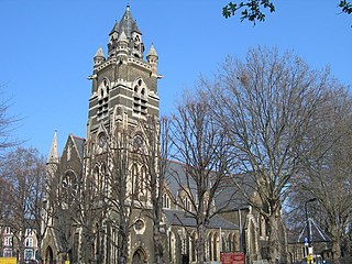
Stoke Newington is an area occupying the northwest part of the London Borough of Hackney, England. The area is five miles northeast of Charing Cross. The Manor of Stoke Newington gave its name to Stoke Newington the ancient parish.

The London Borough of Waltham Forest is an outer London borough formed in 1965 from the merger of the municipal boroughs of Leyton, Walthamstow and Chingford.

Old Street is a 1-mile (1.6 km) street in inner north-east Central London, England that runs west to east from Goswell Road in Clerkenwell, in the London Borough of Islington, via St Luke's and Old Street Roundabout, to the crossroads where it meets Shoreditch High Street (south), Kingsland Road (north) and Hackney Road (east) in Shoreditch in the London Borough of Hackney.

Bishopsgate was one of the eastern gates in London's former defensive wall. The gate's name is traditionally attributed to Earconwald, who was Bishop of London in the 7th century. It was first built in Roman times and marked the beginning of Ermine Street, the ancient road running from London to York (Eboracum). The gate was rebuilt twice in the 15th and 18th centuries, but was permanently demolished in 1760.
Kennington Park is a public park in Kennington, south London and lies between Kennington Park Road and St. Agnes Place. It was opened in 1854 on the site of what had been Kennington Common, where the Chartists gathered for their biggest "monster rally" on 10 April 1848. Soon after this demonstration the common was enclosed and, sponsored by the royal family, made into a public park.
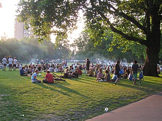
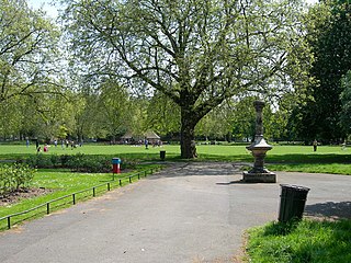
London Fields is a park in Hackney, London, although the name also refers to the immediate area in Hackney surrounding it and London Fields station. It is common land adjoining the Hackney Central area of the London Borough of Hackney. The park covers an area of 12.65 hectares, and includes sporting and recreation facilities. The park's history is recorded as early as the 13th century, and it has been known as London Fields since the mid-16th century.

The London Borough of Hackney, one of the inner London boroughs, has 62 parks, gardens and open spaces within its boundaries, totalling 330 ha. These provide the "green lungs" for leisure activities. Hackney Marshes contain the largest concentration of football pitches in Europe.

Haggerston Park is an open space in Haggerston, in the London Borough of Hackney. It is bounded by Whiston Road, Hackney Road (south) and St Saviour's Priory, Queensbridge Road (west) and Goldsmith's Row (east).

Shoreditch High Street is the old main street of Shoreditch, London. It is part of the A10 road and connects Norton Folgate to the south with Kingsland Road to the north. It constitutes a segment of the Roman Ermine Street, which ran directly north from London to Lincoln and York. The parish church of St Leonard's, Shoreditch is situated at the north-east end of the road, at the crossroads where it meets with Hackney Road.

Springfield Park is a park in Upper Clapton in the London Borough of Hackney.
Haggerston is an area in London, England and is located in the London Borough of Hackney. It is in East London and part of the East End. There is an electoral ward called Haggerston within the borough.
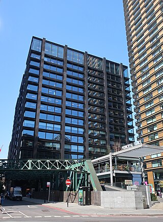
Principal Place is a 15-storey office block in Shoreditch, London, designed by Foster and Partners and completed in 2016. Since 2018, it has been occupied by the internet retailer Amazon.com as its UK headquarters. It is situated at the eastern end of Worship Street, with the main entrance approached across a pedestrian piazza from Shoreditch High Street. Alongside Principal Place, and built as part of the same development, stands a 50-storey residential block named Principal Tower.

Hackney is a district in East London, England, forming around two-thirds of the area of the modern London Borough of Hackney, to which it gives its name. It is 4 miles (6.4 km) northeast of Charing Cross and includes part of the Queen Elizabeth Olympic Park. Historically it was within the county of Middlesex.
Irene Chaplin, known as Ina was a German-born British politician who served on London County Council.

