Krosno County is a unit of territorial administration and local government (powiat) in Lubusz Voivodeship, western Poland, on the German border. It came into being on January 1, 1999, as a result of the Polish local government reforms passed in 1998. Its administrative seat is the town of Krosno Odrzańskie, which lies 30 km (19 mi) west of Zielona Góra and 79 km (49 mi) south of Gorzów Wielkopolski. The only other town is Gubin which is the biggest town in the county. It is situated on the German border 28 km (17 mi) west of Krosno Odrzańskie.

Łosice County is a unit of territorial administration and local government (powiat) in Masovian Voivodeship, east-central Poland. It came into being on January 1, 1999, as a result of the Polish local government reforms passed in 1998. Its administrative seat and only town is Łosice, which lies 118 kilometres (73 mi) east of Warsaw.

Puławy County is a unit of territorial administration and local government (powiat) in Lublin Voivodeship, eastern Poland. It was first established in 1867, but its current borders were established on January 1, 1999, as a result of the Polish local government reforms passed in 1998. Its administrative seat and largest town is Puławy, which lies 46 kilometres (29 mi) north-west of the regional capital Lublin. The county also contains the towns of Nałęczów, lying 23 km (14 mi) south-east of Puławy, and Kazimierz Dolny, 11 km (7 mi) south of Puławy.
Braniewo County is a unit of territorial administration and local government (powiat) in Warmian-Masurian Voivodeship, northern Poland, on the border with Russia. It came into being on January 1, 1999, as a result of the Polish local government reforms passed in 1998. Its administrative seat and largest town is Braniewo, which lies 80 kilometres (50 mi) north-west of the regional capital Olsztyn. The county also contains the towns of Pieniężno, lying 27 km (17 mi) south-east of Braniewo, and Frombork, 11 km (7 mi) west of Braniewo.

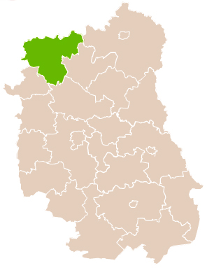
Włodawa County is a unit of territorial administration and local government (powiat) in Lublin Voivodeship, eastern Poland, on the border with Ukraine and Belarus. It was established on January 1, 1999, as a result of the Polish local government reforms passed in 1998. Its administrative seat and only town is Włodawa, which lies 76 kilometres (47 mi) north-east of the regional capital Lublin.
Łuków County is a unit of territorial administration and local government (powiat) in Lublin Voivodeship, eastern Poland. It was established on January 1, 1999, as a result of the Polish local government reforms passed in 1998. Its administrative seat and largest town is Łuków, which lies 76 kilometres (47 mi) north of the regional capital Lublin. The only other town in the county is Stoczek Łukowski, lying 30 km (19 mi) west of Łuków.
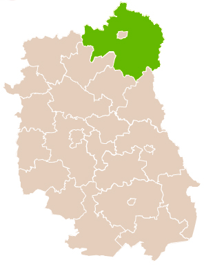
Biała County is a county in Lublin Voivodeship, eastern Poland, on the border with Belarus. It was established on January 1, 1999, as a result of the Polish local government reforms passed in 1998. Its administrative seat is the city of Biała Podlaska, although the city is not part of the county. The only towns in Biała Podlaska County are Międzyrzec Podlaski, which lies 24 km (15 mi) west of Biała Podlaska, and the border town of Terespol, 32 km (20 mi) east of Biała Podlaska.

Tomaszów County is a unit of territorial administration and local government (powiat) in Lublin Voivodeship, eastern Poland, on the border with Ukraine. It was established on January 1, 1999, as a result of the Polish local government reforms passed in 1998. Its administrative seat and largest town is Tomaszów Lubelski, which lies 107 kilometres (66 mi) south-east of the regional capital Lublin. The only other towns in the county are Tyszowce, lying 28 km (17 mi) north-east of Tomaszów, and Łaszczów, lying 25 km (16 mi) east of Tomaszów.

Augustów County is a unit of territorial administration and local government (powiat) in Podlaskie Voivodeship, north-eastern Poland, on the border with Belarus. It came into being on 1 January 1999 as a result of the Polish local government reforms passed in 1998. Its administrative seat and largest city is Augustów, which lies 83 kilometres (52 mi) north of the regional capital Białystok. The only other town in the county is Lipsk, lying 32 km (20 mi) south-east of Augustów.

Sejny County a unit of territorial administration and local government (powiat) in Podlaskie Voivodeship, in the extreme north-east of Poland, on the border with Lithuania and Belarus. It came into being on January 1, 1999, as a result of the Polish local government reforms passed in 1998. Its administrative seat and only town is Sejny, which lies 112 kilometres (70 mi) north of the regional capital Białystok.

Sokółka County is a unit of territorial administration and local government (powiat) in Podlaskie Voivodeship, north-eastern Poland, on the border with Belarus. It was created on 1 January 1999 as a result of the Polish local government reforms passed in 1998. Its administrative seat and largest town is Sokółka, which lies 39 kilometres (24 mi) north-east of the regional capital Białystok. The county also contains the towns of Dąbrowa Białostocka, lying 30 km (19 mi) north of Sokółka, Krynki, lying 24 km (15 mi) south-east of Sokółka, and Suchowola, 33 km (21 mi) north-west of Sokółka.

Hajnówka County is a unit of territorial administration and local government (powiat) in Podlaskie Voivodeship, north-eastern Poland, on the border with Belarus. It came into being on January 1, 1999, as a result of the Polish local government reforms passed in 1998. Its administrative seat and largest town is Hajnówka, which lies 51 kilometres (32 mi) south-east of the regional capital Białystok. The only other town in the county is Kleszczele, lying 25 km (16 mi) south-west of Hajnówka.

Wysokie Mazowieckie County is a unit of territorial administration and local government (powiat) in Podlaskie Voivodeship, north-eastern Poland. It came into being on January 1, 1999, as a result of the Polish local government reforms passed in 1998. Its administrative seat and largest town is Wysokie Mazowieckie, which lies 49 kilometres (30 mi) south-west of the regional capital Białystok. The only other towns in the county are Ciechanowiec, lying 27 km (17 mi) south of Wysokie, Szepietowo, 6 km (4 mi) south of Wysokie, and as from 1 January 2011 Czyżew.

Maków County is a unit of territorial administration and local government (powiat) in Masovian Voivodeship, east-central Poland. It came into being on January 1, 1999, as a result of the Polish local government reforms passed in 1998. Its administrative seat and largest town is Maków Mazowiecki, which lies 73 kilometres (45 mi) north of Warsaw. The only other town in the county is Różan, lying 20 km (12 mi) east of Maków Mazowiecki.
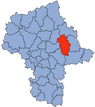
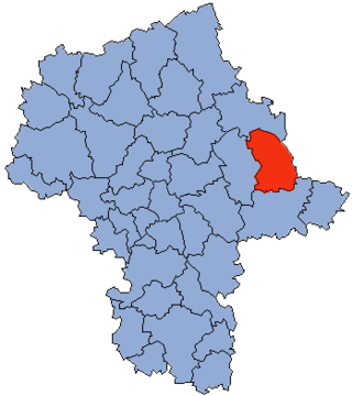
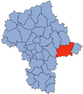
Węgrów County is a unit of territorial administration and local government (powiat) in Masovian Voivodeship, east-central Poland. It came into being on January 1, 1999, as a result of the Polish local government reforms passed in 1998. Its administrative seat and largest town is Węgrów, which lies 73 kilometres (45 mi) east of Warsaw. The only other town in the county is Łochów, lying 26 km (16 mi) north-west of Węgrów.

Przasnysz County is a unit of territorial administration and local government (powiat) in Masovian Voivodeship, east-central Poland. It came into being on 1 January 1999, as a result of the Polish local government reforms passed in 1998. Its administrative seat and largest town is Przasnysz, which lies 90 kilometres (56 mi) north of Warsaw. The only other town in the county is Chorzele, lying 26 km (16 mi) north of Przasnysz. The county covers an area of 1,217.82 square kilometres (470.2 sq mi). As of 2019, its total population is 52,616, out of which the population of Przasnysz is 17,264, that of Chorzele is 3,088, and the rural population is 32,324.
Sokołów County is a powiat in Masovian Voivodeship, east-central Poland. It came into being on January 1, 1999, as a result of the Polish local government reforms passed in 1998. Its administrative seat and largest town is Sokołów Podlaski, which lies 88 kilometres (55 mi) east of Warsaw. The only other town in the county is Kosów Lacki, lying 23 km (14 mi) north of Sokołów Podlaski.
Siedlce County is a unit of territorial administration and local government (powiat) in Masovian Voivodeship, east-central Poland. It came into being on January 1, 1999, as a result of the Polish local government reforms passed in 1998. Its administrative seat is the city of Siedlce, although the city is not part of the county. The only town in Siedlce County is Mordy, which lies 18 km (11 mi) east of Siedlce.

Gorlice County is a unit of territorial administration and local government (powiat) in Lesser Poland Voivodeship, southern Poland, on the Slovak border. It was created on 1 January 1999 as a result of the Polish local government reforms passed in 1998. Its administrative seat and largest town is Gorlice, which lies 100 kilometres (62 mi) south-east of the regional capital Kraków. The only other towns in the county are Biecz, lying 12 km (7 mi) north-east of Gorlice, and Bobowa, 18 km (11 mi) west of Gorlice.

Racibórz County is a unit of territorial administration and local government (powiat) in Silesian Voivodeship, southern Poland, on the Czech border. It came into being on January 1, 1999, as a result of the Polish local government reforms passed in 1998. Its administrative seat and largest town is Racibórz, which lies 58 kilometres (36 mi) west of the regional capital Katowice. The county also contains the towns of Kuźnia Raciborska, lying 16 km (10 mi) north of Racibórz, and Krzanowice, 11 km (7 mi) south-west of Racibórz.