Sierra de la Giganta

Last updated
Sierra de la Giganta
SierraDeLaGiganta 2002 Thomas Kestas.jpg
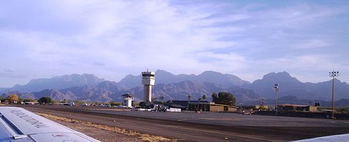
Eastern face, seen from the Gulf of California
Highest point
PeakCerro de la Giganta
Elevation 3,858 ft (1,176 m)
Prominence 1,380 m (4,530 ft)  OOjs UI icon edit-ltr-progressive.svg
Geography
Mexico Baja California Sur location map.svg
Red triangle with thick white border.svg
Sierra de la Giganta
Mexico relief location map.jpg
Red triangle with thick white border.svg
Sierra de la Giganta
Country Mexico
State Baja California Sur
Municipality La Paz Municipality and Loreto Municipality

The Sierra de la Giganta is a mountain range of eastern Baja California Sur state, located on the southern Baja California Peninsula in northwestern Mexico.

Contents

It is a mountain range of the Peninsular Ranges System, which extends 1,500 km (930 mi) from Southern California, through the Baja California Peninsula in Baja California and Baja California Sur states.

Geography

The Sierra de la Giganta extends along the southeastern Baja California Peninsula, parallel and close to the coast of the Gulf of California—Sea of Cortez. The highest point is Cerro de la Giganta at 3,858 feet (1,176 m) in elevation, located near Loreto

The range runs from Loreto in Loreto Municipality west of Loreto, southwards to La Paz Municipality northwest of La Paz. [1]

Ecology

The range is predominantly covered in dry (or xeric) shrubland. The Baja California desert ecoregion covers the Pacific (western) slope of the range, and the Gulf of California xeric scrub ecoregion covers the gulf (eastern) slope. Stream valleys with year-round water sustain palm oases, with groves of the native palm Washingtonia robusta and other moisture-loving plants. [2]

See also

Sierra de la Giganta seen west of the Loreto Airport. Loreto Airport 100 0225.jpg
Sierra de la Giganta seen west of the Loreto Airport.

Related Research Articles

<span class="mw-page-title-main">Baja California peninsula</span> Peninsula on the Pacific coast of Mexico

The Baja California peninsula is a peninsula in northwestern Mexico. It separates the Gulf of California from the Pacific Ocean. The peninsula extends from Mexicali, Baja California, in the north to Cabo San Lucas, Baja California Sur, in the south.

<span class="mw-page-title-main">Baja California Sur</span> State of Mexico

Baja California Sur, officially the Free and Sovereign State of Baja California Sur, is the least populated state and the 31st admitted state of the 32 federal entities which comprise the 31 States of Mexico. It is also the ninth-largest Mexican state in terms of area.

<span class="mw-page-title-main">Sonoran Desert</span> Desert in northwestern Mexico and the southwestern United States

The Sonoran Desert is a desert in North America and ecoregion that covers the northwestern Mexican states of Sonora, Baja California, and Baja California Sur, as well as part of the southwestern United States. It is the hottest desert in both Mexico and the United States. It has an area of 260,000 square kilometers (100,000 sq mi).

<span class="mw-page-title-main">Sierra de San Pedro Mártir</span> Mountain range in northwestern Mexico

Sierra de San Pedro Mártir is a mountain range located within southern Ensenada Municipality and southern Baja California state, of northwestern Mexico.

<span class="mw-page-title-main">Peninsular Ranges</span> Group of mountain ranges in Southern California and northern Mexico

The Peninsular Ranges are a group of mountain ranges that stretch 1,500 km (930 mi) from Southern California to the southern tip of the Baja California peninsula; they are part of the North American Pacific Coast Ranges, which run along the Pacific Coast from Alaska to Mexico. Elevations range from 150 to 3,300 m.

<span class="mw-page-title-main">Loreto, Baja California Sur</span> Town in Baja California Sur, Mexico

Loreto is a city and municipal seat of Loreto Municipality, Baja California Sur, on the West Coast of Mexico. Located on the Gulf of California, the city had a population of 20,385 inhabitants in 2019. Loreto is a regional economic and cultural center, as well as a major tourist destination on the Baja California Peninsula.

<span class="mw-page-title-main">Baja California desert</span> Desert ecoregion of the Baja California Peninsula of Mexico

The Baja California desert is a desert ecoregion of Mexico's Baja California peninsula. This ecoregion occupies the western portion of the Baja California peninsula, and occupies most of the Mexican states of Baja California Sur and Baja California. It covers 77,700 square kilometers. The climate is dry, but its proximity of the Pacific Ocean provides humidity and moderates the temperature. The flora mostly consists of xeric shrubs and over 500 species of recorded vascular plants.

<span class="mw-page-title-main">Madrean pine–oak woodlands</span>

The Madrean pine–oak woodlands are subtropical woodlands found in the mountains of Mexico and the southwestern United States. They are a biogeographic region of the tropical and subtropical coniferous forests and temperate broadleaf and mixed forests biomes, located in North America.

<span class="mw-page-title-main">Misión San Francisco Javier de Viggé-Biaundó</span> 17th century Spanish mission in Baja California Sur, Mexico

<span class="mw-page-title-main">Sierra de Juárez</span> Mountain range in Baja California, Mexico

The Sierra de Juárez, also known as the Sierra Juarez, is a mountain range located in Tecate Municipality and northern Ensenada Municipality, within the northern Baja California state of northwestern Mexico.

<span class="mw-page-title-main">Sierra de la Laguna</span> Mountain range at the southern end of the Baja California Peninsula in Mexico

The Sierra de la Laguna is a mountain range at the southern end of the Baja California Peninsula in Mexico, and is the southernmost range of the Peninsular Ranges System.

<span class="mw-page-title-main">Sierra de la Laguna pine–oak forests</span> Ecoregion in Mexico

The Sierra de la Laguna pine–oak forests are a subtropical coniferous forest ecoregion, found in the Sierra de la Laguna mountain range at the southern tip of the Baja California Peninsula, Mexico.

<span class="mw-page-title-main">Sierra de la Laguna dry forests</span> Ecoregion in Mexico

The Sierra de la Laguna dry forests are a subtropical dry forest ecoregion of the southern Baja California Peninsula in Mexico.

<span class="mw-page-title-main">Juan de Ugarte</span>

Juan de Ugarte, S.J., (1662–1730) was a Jesuit missionary and explorer in Baja California Sur, New Spain, and the successor to Juan María de Salvatierra as head of the peninsula's missions.

<span class="mw-page-title-main">Gulf of California xeric scrub</span> Xeric shrubland ecoregion of the Baja California Peninsula of Mexico

The Gulf of California xeric scrub is a xeric shrubland ecoregion of Mexico's Baja California Peninsula.

<span class="mw-page-title-main">San Lucan xeric scrub</span> Xeric shrubland eoregion of Baja California Sur, Mexico

The San Lucan xeric scrub is a xeric shrubland ecoregion of the southernmost Baja California Peninsula, in Los Cabos Municipality and eastern La Paz Municipality of southern Baja California Sur state, Mexico.

The Sierra de San Francisco is a mountain range in Mulegé Municipality of the northern region of Baja California Sur state, in northwestern Mexico.

<span class="mw-page-title-main">California coastal sage and chaparral</span> Mediterranean forests, woodlands, and scrub ecoregion in Mexico and the United States

The California coastal sage and chaparral is a Mediterranean forests, woodlands, and scrub ecoregion located in southwestern California and northwestern Baja California (Mexico). It is part of the larger California chaparral and woodlands ecoregion.

Valle de los Cirios is a wildlife protection area in the southern portion of the municipality of Ensenada in Baja California, Mexico. At 2,521,776 hectares (9,736.63 sq mi) in area, it is the second-largest wildlife protection area behind El Vizcaíno Biosphere Reserve, but it includes more land than El Vizcaíno.

Southern California Coastal–Baja California is a freshwater ecoregion in Western North America. It covers portions of central and southern California and west of the Coast Ranges as well as most of Mexico's Baja California Peninsula, extending from the southern end of Monterey Bay to the southern tip of the Baja California Peninsula.

References

  1. Albert W. Bally; Allison R. Palmer (1989). Geology of North America—An Overview. Geological Society of America. pp. 245–. ISBN   978-0-8137-5445-1.
  2. "Gulf of California xeric scrub". Terrestrial Ecoregions. World Wildlife Fund.

26°11′N111°37′W / 26.19°N 111.61°W / 26.19; -111.61