Sierraville, California

Last updated

Sierraville
Sierraville 1.jpg
Sierraville
USA California location map.svg
Red pog.svg
Sierraville
Usa edcp location map.svg
Red pog.svg
Sierraville
Coordinates: 39°35′23″N120°22′03″W / 39.58972°N 120.36750°W / 39.58972; -120.36750
Country Flag of the United States.svg  United States
State Flag of California.svg  California
County Sierra
Area
[1]
  Total5.021 sq mi (13.004 km2)
  Land5.020 sq mi (13.002 km2)
  Water0.001 sq mi (0.002 km2)  0.02%
Elevation
[2]
4,957 ft (1,511 m)
Population
 (2010)
  Total200
  Density40/sq mi (15/km2)
Time zone UTC-8 (Pacific (PST))
  Summer (DST) UTC-7 (PDT)
ZIP code
96126
Area code 530
GNIS feature IDs1660231; 2583141
U.S. Geological Survey Geographic Names Information System: Sierraville, California; U.S. Geological Survey Geographic Names Information System: Sierraville, California

Sierraville (Sierra, Spanish for "mountain range" and Ville, French for "town") is a census-designated place [3] in Sierra County, California, United States. [2] It is at the southern end of the huge Sierra Valley which is used primarily as pasture and is also at the junction of California State Route 49 and California State Route 89 southwest of Loyalton. Sierraville has a post office with ZIP code 96126. [4] The post office opened under the name Sierra Valley in 1862 and became known as the Sierraville post office in 1899. [5] The population was 200 as of the 2010 census.

Contents

It is the site of the only traffic signal (a flashing red light) in Sierra County. In the winter of 2007, it was removed after an automobile accident and was replaced in the fall of 2008.

Geography

According to the United States Census Bureau, the CDP covers an area of 5.0 square miles (13.0 km2), 99.98% of it land and 0.02% of it water.

Climate

This region experiences warm (but not hot) and dry summers, with no average monthly temperatures above 71.6 °F. According to the Köppen Climate Classification system, Sierraville has a warm-summer Mediterranean climate, abbreviated "Csb" on climate maps. [6]

Climate data for Sierraville, California, 1991–2020 normals, extremes 1909–present
MonthJanFebMarAprMayJunJulAugSepOctNovDecYear
Record high °F (°C)69
(21)
71
(22)
78
(26)
84
(29)
94
(34)
101
(38)
104
(40)
104
(40)
100
(38)
92
(33)
79
(26)
70
(21)
104
(40)
Mean maximum °F (°C)56.6
(13.7)
60.0
(15.6)
67.4
(19.7)
74.4
(23.6)
81.7
(27.6)
88.2
(31.2)
94.0
(34.4)
92.8
(33.8)
89.4
(31.9)
81.3
(27.4)
69.3
(20.7)
57.3
(14.1)
95.0
(35.0)
Average high °F (°C)44.0
(6.7)
47.4
(8.6)
53.5
(11.9)
59.1
(15.1)
67.5
(19.7)
76.7
(24.8)
85.2
(29.6)
84.8
(29.3)
79.1
(26.2)
67.7
(19.8)
54.7
(12.6)
43.8
(6.6)
63.2
(17.3)
Daily mean °F (°C)31.0
(−0.6)
33.9
(1.1)
39.2
(4.0)
44.1
(6.7)
51.6
(10.9)
58.6
(14.8)
65.2
(18.4)
63.9
(17.7)
58.2
(14.6)
48.4
(9.1)
38.8
(3.8)
30.8
(−0.7)
47.0
(8.3)
Average low °F (°C)18.0
(−7.8)
20.3
(−6.5)
25.0
(−3.9)
29.1
(−1.6)
35.7
(2.1)
40.5
(4.7)
45.3
(7.4)
43.0
(6.1)
37.3
(2.9)
29.3
(−1.5)
23.0
(−5.0)
17.9
(−7.8)
30.4
(−0.9)
Mean minimum °F (°C)2.0
(−16.7)
5.8
(−14.6)
12.3
(−10.9)
19.4
(−7.0)
25.7
(−3.5)
30.3
(−0.9)
36.3
(2.4)
33.4
(0.8)
27.2
(−2.7)
19.2
(−7.1)
10.2
(−12.1)
1.2
(−17.1)
−5.7
(−20.9)
Record low °F (°C)−34
(−37)
−30
(−34)
−15
(−26)
0
(−18)
15
(−9)
20
(−7)
23
(−5)
25
(−4)
14
(−10)
7
(−14)
−13
(−25)
−29
(−34)
−34
(−37)
Average precipitation inches (mm)3.59
(91)
3.84
(98)
3.41
(87)
1.51
(38)
0.94
(24)
0.45
(11)
0.31
(7.9)
0.27
(6.9)
0.39
(9.9)
1.33
(34)
2.23
(57)
4.05
(103)
22.32
(567.7)
Average snowfall inches (cm)6.3
(16)
9.6
(24)
8.1
(21)
2.6
(6.6)
0.1
(0.25)
0.0
(0.0)
0.0
(0.0)
0.0
(0.0)
0.0
(0.0)
0.6
(1.5)
1.9
(4.8)
8.9
(23)
38.1
(97.15)
Average precipitation days (≥ 0.01 in)5.15.66.45.24.01.90.91.11.62.83.75.543.8
Average snowy days (≥ 0.1 in)1.72.01.41.10.00.00.00.00.00.40.61.99.1
Source: XMACIS2 [7]

Demographics

The 2010 United States Census [8] reported that Sierraville had a population of 200. The population density was 39.8 inhabitants per square mile (15.4/km2). The racial makeup of Sierraville was 187 (93.5%) White, 2 (1.0%) African American, 0 (0.0%) Native American, 0 (0.0%) Asian, 0 (0.0%) Pacific Islander, 10 (5.0%) from other races, and 1 (0.5%) from two or more races. Hispanic or Latino of any race were 16 persons (8.0%).

The Census reported that 200 people (100% of the population) lived in households, 0 (0%) lived in non-institutionalized group quarters, and 0 (0%) were institutionalized.

There were 95 households, out of which 13 (13.7%) had children under the age of 18 living in them, 50 (52.6%) were opposite-sex married couples living together, 5 (5.3%) had a female householder with no husband present, 4 (4.2%) had a male householder with no wife present. There were 9 (9.5%) unmarried opposite-sex partnerships, and 0 (0%) same-sex married couples or partnerships. 26 households (27.4%) were made up of individuals, and 7 (7.4%) had someone living alone who was 65 years of age or older. The average household size was 2.11. There were 59 families (62.1% of all households); the average family size was 2.51.

The population was spread out, with 21 people (10.5%) under the age of 18, 12 people (6.0%) aged 18 to 24, 33 people (16.5%) aged 25 to 44, 89 people (44.5%) aged 45 to 64, and 45 people (22.5%) who were 65 years of age or older. The median age was 52.6 years. For every 100 females, there were 117.4 males. For every 100 females age 18 and over, there were 113.1 males.

There were 136 housing units at an average density of 27.1 per square mile (10.5/km2), of which 68 (71.6%) were owner-occupied, and 27 (28.4%) were occupied by renters. The homeowner vacancy rate was 1.4%; the rental vacancy rate was 12.9%. 144 people (72.0% of the population) lived in owner-occupied housing units and 56 people (28.0%) lived in rental housing units.

Politics

In the state legislature, Sierraville is included in the 1st Senate District , represented by Republican Brian Dahle, [9] and the 1st Assembly District , represented by Republican Megan Dahle. [10]

Federally, Sierraville is in California's 1st congressional district , represented by Republican Doug LaMalfa. [11]

Related Research Articles

<span class="mw-page-title-main">Alta Sierra, California</span> Census-designated place in Nevada County, California, U.S.

Alta Sierra is a census-designated place (CDP) in Nevada County, California, United States. The population was 6,911 at the 2010 census, up from 6,522 at the 2000 census.

<span class="mw-page-title-main">Beckwourth, California</span> Census-designated place in California, United States

Beckwourth is a census-designated place (CDP) in Plumas County, California, United States. Beckwourth is located on the Middle Fork Feather River 5 miles (8.0 km) east of Portola. The population was 432 at the 2010 census, up from 342 at the 2000 census.

<span class="mw-page-title-main">Chester, California</span> Census-designated place in California, United States

Chester is a census-designated place (CDP) in Plumas County, California, United States. Chester is located on Lake Almanor, 30 miles (48.3 km) north-northwest of Quincy. The town is located along State Route 36. The US Postal Service ZIP code for the community is 96020. The population was 2,144 at the 2010 census, down from 2,316 at the 2000 census.

<span class="mw-page-title-main">La Porte, California</span> Census-designated place in California, United States

La Porte is a census-designated place (CDP) in Plumas County, California, United States. The population was 26 at the 2010 census, down from 43 at the 2000 census.

<span class="mw-page-title-main">Meadow Valley, California</span> Census-designated place in California, United States

Meadow Valley is a census-designated place (CDP) in Plumas County, California, United States. The population was 453 at the 2020 census, down from 464 at the 2010 census.

<span class="mw-page-title-main">Twain, California</span> Census-designated place in California, United States

Twain is a census-designated place (CDP) in Plumas County, California, United States. As of the 2010 census, the CDP population was 82, down from 87 at the 2000 census.

<span class="mw-page-title-main">Greenview, California</span> Census-designated place in California

Greenview is a census-designated place (CDP) in Siskiyou County, California, United States. Its population is 208 as of the 2020 census, up from 201 from the 2010 census.

<span class="mw-page-title-main">Tennant, California</span> Census-designated place in California

Tennant is a census-designated place (CDP) in Siskiyou County, California, United States. Its population is 63 as of the 2020 census, up from 41 from the 2010 census.

<span class="mw-page-title-main">Cassel, California</span> Census-designated place in California, United States

Cassel is a census-designated place (CDP) in Shasta County, California. Cassel sits at an elevation of 3,176 feet (968 m). Its population is 207 as of the 2020 census, remaining the same from the 2010 census. The ZIP Code is 96016. The community is inside area code 530.

<span class="mw-page-title-main">Herlong, California</span> Census-designated place in California, United States

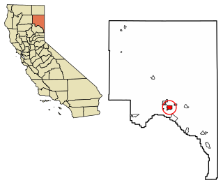
Herlong is a census-designated place in Lassen County, California. Herlong is located at the extreme eastern edge of the Sierra Nevada Mountain Range in the southeastern region of Honey Lake Valley, 8 miles (13 km) north of Doyle, at an elevation of 4,114 feet (1,254 m). Its population is 237 as of the 2020 census, down from 298 from the 2010 census. Herlong is located in southern Lassen County near the southeast edge of Honey Lake, about 70 miles (110 km) north of Reno, Nevada, and about 45 miles (72 km) south of Susanville, the county seat. The community is accessible to U.S. Route 395 via Lassen County Route A25 or Lassen County Route A26.

<span class="mw-page-title-main">Hat Creek, California</span> Census designated place in California, United States

Hat Creek is a census designated place (CDP) in Shasta County, California. Hat Creek is situated at an elevation of 3,422 feet (1,043 m). Its population is 266 as of the 2020 census, down from 309 from the 2010 census.

<span class="mw-page-title-main">Lakehead, California</span> Census-designated place in California, United States

Lakehead is a census-designated place (CDP) in Shasta County, California. Lakehead sits at an elevation of 1,447 feet (441 m). Lakehead is located halfway between Seattle and Los Angeles. Its population is 469 as of the 2020 census, up from 461 from the 2010 census.

<span class="mw-page-title-main">Alleghany, California</span> Census-designated place in California, United States

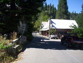
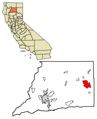
Alleghany is a small census-designated place in Sierra County, California, United States in the Sierra Nevada. It is situated in the Gold Country and continues to be a significant locale for gold mining. The Sixteen To One Mine has been in operation since the days of the California Gold Rush. The town is 20 miles (32 km) from the nearest highway and consists largely of a single main street. The town is home to a post office, a bar, and a mining museum. The population was 58 at the 2010 census.

<span class="mw-page-title-main">Johnstonville, California</span> Census-designated place in California, United States

Johnstonville is a census-designated place in Lassen County, California. It is located 4.5 miles (7 km) east-southeast of Susanville, at an elevation of 4131 feet. Its population is 973 as of the 2020 census, down from 1,024 from the 2010 census.

<span class="mw-page-title-main">Litchfield, California</span> Census-designated place in California, United States

Litchfield is a census-designated place in Lassen County, California. It is located 15 miles (24 km) east of Susanville, at an elevation of 4,065 feet (1,239 m). Its population is 160 as of the 2020 census, down from 195 from the 2010 census.

<span class="mw-page-title-main">California Pines, California</span> Census-designated place in California, United States

California Pines is a census-designated place in Modoc County, California. It lies at an elevation of 4406 feet. Its population is 473 as of the 2020 census, down from 520 from the 2010 census.

<span class="mw-page-title-main">Goodyears Bar, California</span> Census-designated place in California, United States

Goodyears Bar, known as Slaughter's Bar before 1851, is a census-designated place (CDP) in Sierra County, California, United States. Goodyears Bar is located along the North Yuba River and California State Route 49 3.25 miles (5.23 km) west-southwest of Downieville. Goodyears Bar has a post office with ZIP code 95944. The post office opened in 1851.

Sattley, formerly known as Church's Corners, is a census-designated place in Sierra County, California, United States. Sattley is located on California State Route 49 and California State Route 89 southwest of Loyalton. According to the Sattley-Sierraville community association, it was named after resident Harriet Sattley Church. The community board also states that the town was founded in 1881 by Eric Amen, a wealthy prospector. The post office in Sattley opened in 1884.

Verdi is a census-designated place (CDP) in Sierra County, California. Verdi sits at an elevation of 5,315 feet (1,620 m). The 2010 United States census reported Verdi's population was 162. It is just across the state line from Verdi, Nevada and below the Verdi Range.

Sierra Brooks is a census-designated place (CDP) in Sierra County, California. Sierra Brooks sits at an elevation of 5,180 feet (1,580 m). The 2010 United States census reported Sierra Brooks's population was 478.

References

  1. U.S. Census Archived 2012-01-25 at the Wayback Machine
  2. 1 2 U.S. Geological Survey Geographic Names Information System: Sierraville, California
  3. U.S. Geological Survey Geographic Names Information System: Sierraville, California
  4. ZIP Code Lookup
  5. Durham, David L. (1998). California's Geographic Names: A Gazetteer of Historic and Modern Names of the State. Quill Driver Books. p. 555. ISBN   1-884995-14-4.
  6. Climate Summary for Sierraville, California
  7. "xmACIS2". National Oceanic and Atmospheric Administration. Retrieved March 4, 2023.
  8. "2010 Census Interactive Population Search: CA - Sierraville CDP". U.S. Census Bureau. Archived from the original on July 15, 2014. Retrieved July 12, 2014.
  9. "Senators". State of California. Retrieved March 10, 2013.
  10. "Members Assembly". State of California. Retrieved March 2, 2013.
  11. "California's 1st Congressional District - Representatives & District Map". Civic Impulse, LLC. Retrieved March 3, 2013.