Silloth

Last updated

Silloth
  • Silloth-on-Solway
Town and parish
Criffel Street, Silloth.jpg
Criffel Street, Silloth
Location map United Kingdom Allerdale.svg
Red pog.svg
Silloth
Location in the former Allerdale district
Cumbria UK location map.svg
Red pog.svg
Silloth
Location within Cumbria
Population2,906 (2011)
OS grid reference NY113536
Civil parish
  • Silloth-on-Solway
Unitary authority
Ceremonial county
Region
Country England
Sovereign state United Kingdom
Post town WIGTON
Postcode district CA7
Dialling code 016973
Police Cumbria
Fire Cumbria
Ambulance North West
UK Parliament
List of places
UK
England
Cumbria
54°52′08″N3°22′52″W / 54.869°N 3.381°W / 54.869; -3.381

Silloth (sometimes known as Silloth-on-Solway) is a port town and civil parish in Cumberland, Cumbria, England. Historically in the county of Cumberland, the town is an example of a Victorian seaside resort in the North of England.

Contents

Silloth had a population of 2,932 at the 2001 Census, [1] falling slightly to 2,906 at the 2011 Census. [2]

Location

It sits on the shoreline of the Solway Firth, 18+34 miles (30 kilometres) north of Workington and 22 miles (35 kilometres) west of Carlisle. The town of Maryport lies 12 miles (19 kilometres) south, down the B5300 coast road which also passes through the villages of Blitterlees, Beckfoot, Mawbray, and Allonby. Wigton is 12 miles (19 kilometres) east, along the B5302 road, which also passes through the village of Abbeytown, 5+12 miles (9 kilometres) southeast.

History

Silloth developed in the 1860s onwards around the terminus of the railway from Carlisle and associated docks, which had begun construction in 1855 to replace Port Carlisle as the deep-water port for Carlisle.

Workers from the factories of Carlisle were presented with access to the seaside, and the town flourished as a destination for day trippers. The town reached the peak of its popularity in the late 19th and early 20th centuries.

Etymology

'Silloth' means "'sea barn(s)', v. 'sǣ hlaða'." [3] (The first word is Old English, the second is Old Norse).

Governance

Silloth is part of the Workington constituency of the UK parliament. The current Member of Parliament as of 2019 is Mark Jenkinson, a Conservative, who unseated former Labour MP Sue Hayman at the 2019 General Election. [4]

For local government purposes, it is in the Cumberland unitary authority.

Silloth has its own Parish Council: Silloth-on-Solway Town Council. [5]

Churches

Christ Church, Silloth, occupies a complete rectangle of the planned town Christ Church, Solway - geograph.org.uk - 87858.jpg
Christ Church, Silloth, occupies a complete rectangle of the planned town

Silloth's largest church is Christ Church, situated in a complete rectangular plot which was planned into the original town design. It is on a commanding site at Criffel Street and the body of the church was completed in 1870. [6] The porch tower and large broach spire were completed later in 1878, and house a ring of 8 bells which are chimed. It was designed by Carlisle architect Charles John Ferguson in the Gothic style, and is built with an interesting mix of local sandstone, and granite which was brought by the North British Railway (and boats) from Newry, now in Northern Ireland. Much of the interior is faced with yellow brick trimmed with red. [7]

There are several churches and chapels of other denominations in the town.

Industry

Silloth docks 2008 LorePrahmSilloth.jpg
Silloth docks 2008

Port of Silloth

The Port of Silloth is owned and operated by Associated British Ports. The main cargoes are wheat, fertiliser, molasses, forest products and general cargo. [8]

Carr's Flour Mill

An example of a Victorian flour mill, the building was constructed adjacent to the New Dock in 1887. Carr's flour mill is an operating mill which supplies flour to a number of food manufacturers such as United Biscuits, [9] Warburtons and several other leading bakeries and confectioners. Carr's Flour Mill is now owned by Whitworths.

Cheri Foam

Silloth Airfield factory Silloth Factory arial photo.jpg
Silloth Airfield factory

In the 1960s two businesses that had outgrown their factory in Whitehaven re-located to Silloth airfield. They were Cumberland Curled Hair and Cheri Foam. They were one of the largest employers in the area until the late 1970s. Cheri Foam, was owned by Kurt Oppenheim, who had established his business originally in Whitehaven in 1946. He bought two of the hangars on the airfield and later joined them together to create large factory space and storage units for the manufacture of polyurethane foam blocks. This was an industrial chemical process and a foam block conversion unit ('Conversion' means that the blocks were cut up into shapes like cushions and sheets to be supplied to the furniture, bedding and motor industries). In 1973 an additional factory unit was added to house the production of foam moulded car parts by high pressure injection foam machines. Machinery equipment in the factory was largely manufactured by a team of Silloth metal fitters and local electricians employed full time by the factory. There was a laboratory and a fibreglass mould making unit on site as well as a garaging unit to service the fourteen container vans that the company used to ship its production all over the UK. It was a twenty four hours a day operation with production leaving the works at all hours. The logo Cheri Foam on the sides of vans was very familiar in the area. About a hundred and fifty people worked in this factory, some from Silloth and many bussed in from Maryport and surrounds each day. The business was acquired by the Beaver Group in 1976 and Oppenheim retired to join his family in London. The main customer Times Furnishing eventually closed and after this the business ran down and eventually closed.[ citation needed ]

Other

Local contractor D.A. Harrison are based in Silloth, employing 200 people. [10] [11]

Notable people

Tourism

Silloth has long been a popular tourist destination. SillothPierPostcard.jpg
Silloth has long been a popular tourist destination.

Tourism is a major contributor to the economy in Silloth, with dozens of large and small static and touring caravan parks located within a 10 miles (15 kilometres) radius of the town centre, resulting in a large increase in the population during the summer months.

Silloth hosts several small annual events held on the town green. These include a beer festival held in September, plus a steam rally, kite and food festivals. [12]

Amenities include a golf course. [13]

Media

A local 'free' newspaper published monthly entitled The Solway Buzz, distributed to households in the area by a team of volunteers, covers news and events in Silloth and the surrounding area. [14] The town is also served by the regional newspaper the News & Star . [15]

Local TV coverage is provided by BBC North East and Cumbria and ITV Border. Television signals are received from the Caldbeck TV transmitter. [16]

Local radio stations are BBC Radio Cumbria on 95.6 FM, Greatest Hits Radio Cumbria & South West Scotland on 96.4 FM and Solway Radio, a community based radio station. [17]

Airfield

The airfield opened in June 1939, just before the start of the Second World War, and closed on 31 December 1960. Originally designed to be used by RAF Maintenance Command, 22MU, the airfield was handed over to Coastal Command during November 1939. No 1 Operational Training Unit (OTU) was then responsible for training pilots and crews from the UK and Allied Countries. Therefore, the aerodrome had twin responsibilities, the maintenance and repair of planes for use in the war effort and the training of crews from allied countries to fly planes. [18]

Transport

Railway

The railway to Silloth opened in 1856. The line passed through the villages of Kirkbride and Abbeytown to Carlisle. The railway carried both passengers and freight from the port, and tourists visiting the town. It was closed as part of the Beeching cuts in 1964. [19]

Road

Silloth is on the B5302 road, which leads to the A596 and the town of Wigton, and the B5300 which connects the town to Maryport.

See also

Related Research Articles

<span class="mw-page-title-main">Workington</span> Coastal town in Cumbria, England

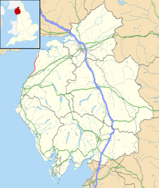
Workington is a coastal town and civil parish at the mouth of the River Derwent on the west coast in Cumberland, Cumbria, England. At the 2011 census it had a population of 25,207.

<span class="mw-page-title-main">Allerdale</span> Former non-metropolitan district in England

<span class="mw-page-title-main">Maryport</span> Town in Cumbria, England

Maryport is a town and civil parish in Cumbria, England.

<span class="mw-page-title-main">Wigton</span> Market town in Cumbria, England

Wigton is a market town in Cumberland, Cumbria, England. It lies just outside the Lake District. Wigton is at the centre of the Solway Plain, between the Caldbeck Fells and the Solway coast. It is served by Wigton railway station on the Cumbrian Coast Line, and the A596 road to Workington. The town of Silloth-on-Solway lies 12 miles (19 km) to the west, beyond Abbeytown.

<span class="mw-page-title-main">Abbeytown</span> Human settlement in England

Abbeytown, also known as Holme Abbey, is a village and civil parish in the Allerdale borough of Cumbria, England.

<span class="mw-page-title-main">Bowness-on-Solway</span> Human settlement in England

Bowness-on-Solway is a village in Cumbria, England. It is situated to the west of Carlisle on the southern side of the Solway Firth estuary separating England and Scotland. The civil parish had a population of 1,126 at the 2011 census. The western end of Hadrian's Wall is a notable tourist destination, though the Wall itself is no longer to be seen here above ground. The west end of the Hadrian's Wall Path is marked by a pavilion on the small coastal cliff at Bowness. The village is part of the Solway Coast Area of Outstanding Natural Beauty.

<span class="mw-page-title-main">Blitterlees</span> Human settlement in England

Blitterlees is a small hamlet in the parish of Holme Low, one mile south of Silloth in Cumbria, United Kingdom. The hamlet of Wolsty is located approximately 1 mile (1.6 km) to the south as the crow flies, or 2.25 miles (3.62 km) by road, and Cumbria's county town, Carlisle, is located 23 miles (37 km) to the east. The B5300, known locally as the "coast road", runs through the village on its way to Beckfoot, Mawbray, Allonby, and ultimately Maryport.

<span class="mw-page-title-main">Mawbray</span> A village on the Cumbrian coast in England

Mawbray is a village in the civil parish of Holme St Cuthbert in Cumbria, England. Historically part of Cumberland. It is located on the Solway Plain, 5.2 miles (8.4 km) south west of Silloth, 7.9 miles (12.7 km) north of Maryport, and 25 miles (40 km) west of Carlisle. The B5300, known locally as the "coast road" runs to the west of the village.

<span class="mw-page-title-main">B5300 road</span> A road on the Cumbrian coast in England.

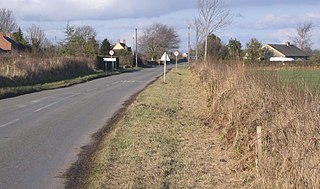
The B5300 is a B road which runs for approximately twelve miles between the towns of Silloth and Maryport in the Allerdale borough of Cumbria, United Kingdom. From north to south, it passes through the villages of Blitterlees, Beckfoot, Mawbray, Dubmill, and Allonby. It runs through the Solway Coast Area of Outstanding Natural Beauty, passes close to the Salta Moss Site of Special Scientific Interest, Milefortlet 21, a Roman archaeological site, the salt pans, a remnant of the Solway plain's medieval saltmaking industry, and the village of Crosscanonby. It is an important route for carrying goods to and from Silloth docks and Maryport harbour. It is also the major road connecting smaller coastal settlements with Maryport and Silloth, from where other roads lead to Workington, Whitehaven, Wigton, and Carlisle. A short section of the road between Dubmill and Mawbray was closed in February 2019 due to coastal erosion, and reopened in June 2019.

There were two interlinked railways on the south shore of the Solway Firth.

<span class="mw-page-title-main">Pelutho</span> A hamlet in Cumbria, England

Pelutho is a hamlet in the civil parish of Holme St. Cuthbert in Cumbria, historically in Cumberland, England.

<span class="mw-page-title-main">Holme Low</span> A civil parish in Cumbria, England

Holme Low is a civil parish in the Allerdale borough of Cumbria, United Kingdom. It borders the parishes of Holme St. Cuthbert and Holme Abbey to the south, the town of Silloth-on-Solway to the north-west, and has a short stretch of coastline on the Solway Firth to the west. To the north, it is bordered by lands common to Holme St. Cuthbert, Holme Low, and Holme Abbey, which is an unpopulated area. Holme Low had a population of 373 in 137 households at the 2001 census, reducing slightly in the 2011 Census to a population of 362 in 162 households.

<span class="mw-page-title-main">New Cowper</span> A hamlet in Cumbria, England

New Cowper is a small hamlet in the civil parish of Holme St. Cuthbert in Cumbria, United Kingdom. It is located three-and-a-half miles south-east of the village of Mawbray, one-and-a-half miles north-west of Westnewton, and twenty-one-and-a-half miles south-west of Carlisle, Cumbria's county town.

<span class="mw-page-title-main">Tarns, Cumbria</span> A settlement in Cumbria, England

Tarns is a small farming settlement in the civil parish of Holme St. Cuthbert in Cumbria, United Kingdom. It is located two miles north-east of the village of Mawbray, and twenty-three miles south-west of Carlisle, Cumbria's county town. The B5301 road runs through the settlement, and along that road the town of Silloth-on-Solway is located five-and-a-half miles to the north, and Aspatria four-and-a-half miles to the south-east. Other nearby settlements include Aikshaw, Goodyhills, Jericho, and New Cowper.

<span class="mw-page-title-main">Wolsty</span> A hamlet in Cumbria, England

Wolsty is a small hamlet in the civil parish of Holme Low in Cumbria, England. It is located three-and-a-quarter miles south of Silloth-on-Solway, five miles west of Abbeytown, three-and-a-quarter miles north of the village of Mawbray, and twenty-three miles west of Cumbria's county town, Carlisle. The B5300 coast road, which heads north toward Silloth-on-Solway and south to Mawbray, Allonby, and Maryport, is three-quarters of a mile away by road, or less than a quarter of a mile by way of an unpaved farm track.

<span class="mw-page-title-main">B5302 road</span> A road in Cumbria, England

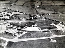
The B5302 is a B road which runs for approximately twelve-and-a-quarter miles between the towns of Silloth-on-Solway and Wigton in Cumbria, United Kingdom. From west to east, it passes through the villages of Causewayhead, Calvo, Abbeytown, Wheyrigg, and Waverbridge, and also passes near to Blackdyke and Blencogo. At its eastern end, it comes very close to the Solway Coast Area of Outstanding Natural Beauty, and passes by Silloth Airfield, left over from the Second World War. Several of the villages that the road passes through were formerly served by trains on the single-track Carlisle and Silloth Bay Railway, which closed with the Beeching axe in the 1960s. It is the main road connecting Silloth-on-Solway and surrounding settlements with the A596, and by extension, the city of Carlisle.

<span class="mw-page-title-main">Holme East Waver</span> A civil parish in Cumbria, England

Holme East Waver is a civil parish in Cumbria, United Kingdom. It is bordered to the north by the civil parish of Bowness-on-Solway, to the east by the civil parishes of Kirkbride, Woodside, and Waverton, and to the south by the civil parishes of Dundraw and Holme Abbey, lands common to Holme St. Cuthbert, Holme Low, and Holme Abbey, and the town of Silloth-on-Solway. At the 2001 census, it had a population of 306 in 121 households, increasing slightly at the 2011 Census to a population of 318 in 130 households. It is named for the River Waver, and the rivers Waver and Wampool enter the Solway Firth at the western end of the parish. Part of the Solway Coast Area of Outstanding Natural Beauty is within the parish of Holme East Waver. The largest village is Newton Arlosh.

<span class="mw-page-title-main">Kelsick</span> A hamlet in Cumbria, England

Kelsick is a hamlet in the civil parish of Dundraw in Cumbria, United Kingdom. It is located approximately 1.8 miles (2.9 km) southeast of Abbeytown, 0.9 miles (1.4 km) northwest of Dundraw, and 14.5 miles (23.3 km) west of Carlisle, Cumbria's county town. Kelsick is accessed by two side-roads off the B5302 road, which runs between Silloth and Wigton.

References

  1. Office for National Statistics : Census 2001 : Parish Headcounts : Allerdale Archived 13 June 2011 at the Wayback Machine Retrieved 30 October 2010
  2. "Parish population 2011". Archived from the original on 18 June 2015. Retrieved 18 June 2015.
  3. Armstrong, A. M.; Mawer, A.; Stenton, F. M.; Dickens, B. (1950). The place-names of Cumberland. English Place-Name Society, vol.xx. Vol. Part 2. Cambridge: Cambridge University Press. pp. 293–4.
  4. "Tories win Workington from Labour". BBC News. 13 December 2019. Retrieved 13 December 2019.
  5. "Silloth-on-Solway Town Council".
  6. Silloth – Christ Church Archived 6 August 2007 at the Wayback Machine
  7. Hyde, Matthew; Pevsner, Nikolaus (2010) [1967], Cumbria, The Buildings of England, New Haven and London: Yale University Press, ISBN   978-0-300-12663-1
  8. "Associated British Ports". Archived from the original on 22 September 2007. Retrieved 24 August 2007.
  9. The Cumberland News Archived 28 September 2007 at the Wayback Machine
  10. "Plans for new quarry in north Cumbria".
  11. "Plans to demolish eight buildings at Silloth Industrial Estate".
  12. "Silloth Green".
  13. "Silloth Golf Club". Silloth Golf Club. 9 November 2012. Retrieved 31 May 2013.
  14. "The Solway Buzz" . Retrieved 1 November 2023.
  15. "News & Star" . Retrieved 1 November 2023.
  16. "Full Freeview on the Caldbeck (Cumbria, England) transmitter". UK Free TV. 1 May 2004. Retrieved 1 November 2023.
  17. "Solway Radio" . Retrieved 1 November 2023.
  18. "Silloth Airfield' Project".
  19. Barker 2010, p. 426.

Sources

Commons-logo.svg Media related to Silloth at Wikimedia Commons