Silverwood, Ayrshire

Last updated

Scotland relief location map.jpg
Red pog.svg
Silverwood Estate
The location of the old Silverwood Estate, East Ayrshire

Silverwood in the Parish of Kilmarnock lies in East Ayrshire, Scotland. This was once a small estate with a mansion house; it is now a farm. The plantation nearby is named after it.

Contents

History

The estate

Silverwood circa 1654 by Timothy Pont. Sylverwood.jpg
Silverwood circa 1654 by Timothy Pont.

Timothy Pont's map of circa 1654 (See illustration) shows 'Sylverwood' with wooded policies and a pale encircling it on three sides, the Templeton Burn forming the boundary to the West. The land is referred to in 1691 as being the three pound land of old extent. In circa 1640 Hew Montgomerie of Silverwood was one of the rentallers of Grougar and the valuation was £76 9s 4d. [1]

A map showing the site of Silverwood. Templeton Burn.jpg
A map showing the site of Silverwood.

The lands in 1640 lay in the Bailliary of Kilwinning and the regality of Torphichen; regality being defined as a territorial jurisdiction of a royal nature conferred by the sovereign, here the jurisdiction was over lands which had belonged to the Knights Templar. The regality was called Temple-Cuninghame.

Hew (Hugh) Montgomerie of Silverwood was the brother of Robert Montgomerie of Hessilhead and in 1672 he was heir to the hereditary bailieship of all the Temple lands and tenements within the Bailiary of Cuninghame and regality of Kilwinning. He was Sheriff Depute of Renfrewshire and as such was involved in a number of contemporary court cases. [2] Hugh's wife was a Helen Tran and his son was Alexander Montgomerie. [3] Hugh stood as a witness to his brother being invested in the Barony of Giffen on 19 June 1663. [4]

The Templeton Burn in the Armsheugh Plantation near Crookedholm. Templeton Burn in Armsheugh.jpg
The Templeton Burn in the Armsheugh Plantation near Crookedholm.

Temple-Cuninghame was a tenandry in that the land and other property, etc. was let for rent, rather than retained in the superior’s own hands. In 1614 Hugh had given a bell to Beith (Old Kirk), inscribed THIS . BELL . WAS . GIVEN . BY . HUGH MONTGOMERIE . SON . TO . HESSILHEAD . ANNO . 1614 . [5]

In 1691 John Cuming was laird of Silverwood. He was the son of Matthew Cuming, a merchant in Glasgow, and held the lands at an annual rent of £78 16s 5d. His mother was Jean Howatt to whom the lands had passed via her grandfather, James Howatt. [3] The Hearth Tax records for this year show the 'Lands of Silverwood' had ten dwellings; one hearth each for Silverwood and Templeton, four for Milton. [6]

Aiton records that Silverwood Farm was 73 acres in extent and prior to 1776 was leased for £5 and 5 bolls of meal per annum for a 19 year period; it had risen to £200 per annum in 1811. [7]

By 1876 the lands of Silverwood had become part of the estates belonging to the Duke of Portland. [1] The 6 inch OS maps of the 19th century show a formal laid out garden with a nearby orchard. [8]

Silverwood Farm is now (2008) privately owned.

William Aiton (sheriff), author in the early 1800s of ‘A Treatise on Moss-earth’; ‘General View of the Agriculture of the County of Ayr’; ‘General View of the Agriculture of the County of Bute’; ‘A History of the Rencounter at Drumclog and Battle at Bothwell Bridge’; ‘An Inquiry into the Pedigree of the Hamilton Family’; and an ‘Inquiry into the House of Aiton in Scotland,’ was from Silverwood.

Silverwood

It is not certain how the name arose, however the name may indicate a link to Silver Birch trees which give a silver appearance, especially in winter, at a distance. This species would have predominated in the Templetonburn Glen as the typical climatic vegetation for this habitat when the area was less well drained and free from artificial plantings.

Natural history of the Templeton burn and Silverwood

The Silverwood and Hillhouse plantations make up the Templetonburn Wildlife Site which as the map shows, contains a good biodiversity, despite the predominance of pine trees, especially Scots Pine, in many areas. Species include Roe deer, Enchanter's Nightshade, oak, blackthorn, bracken, Stinkhorn fungus (Phallus impudicus) and the Oak apple Gall, unusual in the Scottish context. Buzzards are found here, the rotten pine trunks show much woodpecker activity and badgers setts are present; the badgers clearly being persecuted by unknown persons (2008). The Templetonburn joins the River Irvine shortly after leaving the wood. The wood contains what appears to be the remains of an old march dyke and several depressions within the site are suggestive of old limestone workings.

Templetonburn

Several properties of this name have existed nearby over the years. The 1901 Templetonburn House was designed by James K. Hunter and was one of his finest works. It was destroyed by fire shortly before it was due to open as a hotel. [9]

Grougar

This was a valuable Barony, linked to Lambroughton through it having been part of the possessions of the De Morvilles up until the time of King Robert the Bruce. In 1320 Sir Robert Cuninghame of Kilmaurs held the lands and later the Logans of Restalrig came into possession. William Blane of Grougar held the lands in 1876. The present Baron of Grougar is Professor David Ian McLean. The property of 2,000 acres (8.1 km2) never seems to have had a manor house built upon it. [10] Grougar Mains Farm borders the East side of Silverwood plantation.

The Scottish feudal barony of Grougar contained 70 acres of the lands of Caprickhill, including Holmhead and Miltonmill. In 1742 these lands had belonged to Thomas Millar and were sold to William Wallace for £170; in 1811 the properties were worth £7,000. Laighmilton also lay in Grougar and in 1766 its rental was 1s 8d per acre, rising to £4 per acre in 1811. [7]

Related Research Articles

Barony and Castle of Corsehill Barony in East Ayrshire, Scotland

The old Barony and castle of Corsehill lay within the feudal Baillerie of Cunninghame, near Stewarton, now East Ayrshire, Scotland.

Kerelaw Castle

Kerelaw Castle is a castle ruin owned by a surviving male descendant of the Hamilton family, Logan Neely. It is situated on the coast of North Ayrshire, Scotland in the town of Stevenston.

Hessilhead

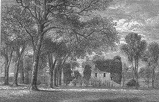
Hessilhead is in Beith, North Ayrshire, Scotland. Hessilhead used to be called Hazlehead or Hasslehead. The lands were part of the Lordship of Giffen, and the Barony of Hessilhead, within the Baillerie of Cunninghame and the Parish of Beith. The castle was situated at grid reference NS380532.

Eglinton Castle Gothic castellated mansion in Kilwinning, Scotland

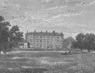
Eglinton Castle was a large Gothic castellated mansion in Kilwinning, North Ayrshire, Scotland.

Barony and Castle of Giffen Barony in the former District of Cunninghame, now North Ayrshire

The Barony of Giffen and its associated 15th-century castle were in the parish of Beith in the former District of Cunninghame, now North Ayrshire. The site may be spelled Giffen or Giffin and lay within the Lordship of Giffin, which included the Baronies of Giffen, Trearne, Hessilhead, Broadstone, Roughwood and Ramshead; valued at £3,788 9s 10d. The Barony of Giffen comprised a number of properties, including Greenhills, Thirdpart, Drumbuie, Nettlehirst and Balgray, covering about half of the parish of Beith. Giffen was a hundred merk land, separated from the Barony of Beith, a forty-pound land, by the Powgree Burn which rises on Cuff hill. The Lugton Water or the Bungle Burn running through Burnhouse may have been the Giffen barony boundary with that of the adjacent barony and lands of Aiket castle.

Montgreenan

Montgreenan is an estate in North Ayrshire, Parish of Kilwinning, Scotland. The Lugton Water runs through the policies and farmland of Montgreenan. Nearby are the hamlets of Torranyard and Auchentiber.

Caldwell, East Renfrewshire

Caldwell is a mansion and old estate with the remains of a castle nearby. These lands lie close to the Lugton Water and the villages of Uplawmoor in East Renfrewshire and Lugton in East Ayrshire.

Giffordland Barony in North Ayrshire, United Kingdom

Giffordland is in North Ayrshire, Parish of Dalry (Cunninghame) in the former Region of Strathclyde, Scotland.

Lands of Lainshaw The Lands Of Lainshaw Have Been In Place For Many Years And Was Used In The War.

The Lands of Lainshaw lie in Strathannick and were part of the Lordship of Stewarton, in East Ayrshire, Scotland. Lainshaw House is a category B listed mansion, lying in a prominent position above the Annick Water and its holm in the Parish of Stewarton, Scotland. Part of the much older Lainshaw Castle is contained within the several later building phases of the present day Lainshaw House. The names 'Langshaw' or 'Langschaw' were used in historic times. Law Mount near the High and Laigh Castleton farms has been suggested as the site of the original castle, granted in the 12th century to Godfrey de Ross by Hugo de Morville.

Loch Brand

Loch Brand or Loch of Boghall was a loch situated in a depression between the Grange Estate, Crummock, Hill of Beith Castle site and Boghall in the Parish of Beith, North Ayrshire, Scotland. The loch was fed by the Grange Burn and surface runoff, such as from the old rig and furrows indicated by Roy's Maps of the mid 17th century. The loch was drained by the Boghall Burn that runs passed the 'Court Hill' and into Powgree Burn at Gateside.

Hessilhead Loch

Hessilhead Loch or Hazelhead Loch was situated in a low-lying area near the old Castle of Hessilhead in the Parish of Beith, North Ayrshire, Scotland. The old loch, used in the defence of the castle, was probably infilled when the castle ruins were landscaped in the 19th century.

Lands of Ashgrove

The Lands of Ashgrove, previously known as Ashenyards, formed a small estate in the Parish of Kilwinning, North Ayrshire, lying between Kilwinning and Stevenston. The Georgian mansion house was demolished in 1960, the substantial walled garden survives.

The Lands of Roughwood

Roughwood once Ruchwood is a farm, originally a estate, possessing at one time a small tower castle. Roughwood is situated near to the town of Beith in North Ayrshire, Scotland; the lands lay within the old Lordship of Giffen.

Barony of Kersland

The remains of the old castle of Kersland lie about 1.5 miles to the north-east of the town of Dalry in North Ayrshire, Scotland, in the old Barony of Kersland. The River Garnock lies nearby.

Swindridgemuir House and estate were composed of the 'Lands of Swindridgemuir' and the dwelling house about two miles north-east of Dalry in the old Barony of Kersland, about a mile and a half north of the Blair Estate, North Ayrshire, Scotland. The spelling on the family memorials at Ayr Auld Kirk is 'Swindrigemuir'.

The Lands of Doura, Dawra, Dawray, DowreyDowray, Dourey or Douray formed a small estate, at one time part of the Barony of Corsehill and Doura, situated near the Eglinton Estate in the Parish of Kilwinning, North Ayrshire, Scotland.

Lands of Willowyard

The ancient lands of Willowyard, Willieyeards, Williyard or Willizeards were part of the holdings of the Regality of Kilwinning, Barony of Beith, and Bailiary of Cuninghame. They later became the property of the Montgomerie family before being sold to the Simson family in 1723. The manor house still survives as part of a business premises and the nearby industrial estate and whisky bond carry the name 'Willowyards'.

Lands of Marshalland

The lands of Marshalland, Marsheland, Marsheyland or Marshyland were part of the holdings of the Barony of Beith, Regality of Kilwinning and Bailiary of Cuninghame. They became the property of the Lyle family, then the Shedden family, passing next to the Spier's family before finally becoming part of the Spier's Trust lands. The laird's house and farm were demolished in the 1960s.

Lands of Templehouse Human settlement in Scotland

The Lands of Templehouse formed a small estate lying between Aiket Castle and the town of Dunlop, East Ayrshire, Parish of Dunlop, Scotland. The laird's house at Templeland of Dunlop Hill, to give it its formal name, stood near to the ancient road leading from Dunlop to Kirkwood and on to Kennox. The lands were held by the Knights Templar until a date prior to 1570 when the Gemmells of Templehouse were granted the property and remained there until 1962, a period of around 500 years. The spelling 'Gemmell' is used for consistency except where otherwise denoted.

Lands of Blacklaw Human settlement in Scotland

The Lands of Blacklaw formed a small property of five merks worth, in the Lordship of Stewarton at the eastern extremity of Strathannick, between the hamlet of Kingsford in East Ayrshire and the East Renfrewshire boundary, Scotland. It was first recorded in 1484 in the Acta Auditorum. Black Law is a prominent whinstone crag lying above Blacklaw Hill Farm.

References

  1. 1 2 Dobie, James (1876), Cuninghame, Topographised by Timothy Pont, A.M., 1604-1608, etc. Pub. John Tweed,. Glasgow. P. 374.
  2. Siverwood Papers(1670). Scottish National Archives.
  3. 1 2 Dobie, James (1876), Cuninghame, Topographised by Timothy Pont, A.M., 1604-1608, etc. Pub. John Tweed,. Glasgow. P. 375.
  4. Dobie, James (MDCCCXVI). Memoir of William Wilson of Crummock. Private Printing. Edinburgh. P. 179.
  5. Clouston, Ranald W. M., The Church Bells of Ayrshire. Ayr Arch & Nat Hist Soc, Collections 1947 - 1949. P. 215.
  6. Urquhart, Robert H. et al. (1998). The Hearth Tax for Ayrshire 1691. Ayrshire Records Series V.1. Ayr : Ayr Fed Hist Soc ISBN   0-9532055-0-9. p. 85
  7. 1 2 Aiton, William (1811). General View of The Agriculture of the County of Ayr; observations on the means of its improvement; drawn up for the consideration of the Board of Agriculture, and Internal Improvements, with Beautiful Engravings. Glasgow. p. 169
  8. Ordnance Survey 6 inch to the mile Maps. Archived 2009-03-04 at the Wayback Machine
  9. Love, Dane (2003), Ayrshire: Discovering a County. Fort Publishing Ltd., Ayr. ISBN   0-9544461-1-9 P. 124.
  10. Dobie, James (1876), Cuninghame, Topographised by Timothy Pont, A. M., 1604-1608, etc. Pub. John Tweed,. Glasgow. P. 186 - 187.

Coordinates: 55°37.111′N4°26.834′W / 55.618517°N 4.447233°W / 55.618517; -4.447233