Princeton is a town municipality in the Similkameen area of southern British Columbia, Canada. The former mining and railway hub lies at the confluence of the Tulameen into the Similkameen River, just east of the Cascade Mountains. It is at the junction of BC Highway 3 and 5A.
Hedley is an unincorporated community near the mouth of Hedley Creek in the Similkameen region of southern British Columbia. The former mining town, on BC Highway 3, is by road about 74 kilometres (46 mi) southwest of Penticton and 38 kilometres (24 mi) southeast of Princeton.

The Similkameen River runs through southern British Columbia, Canada, eventually discharging into the Okanagan River near Oroville, Washington, in the United States. Through the Okanagan River, it drains to the Columbia River. The river is said to be named for an indigenous people called Similkameigh, meaning "treacherous waters".
Boundary-Similkameen is a provincial riding formed in 2008. It includes the populations of Penticton-Okanagan Valley, West Kootenay-Boundary and Yale-Lillooet. The riding's name corresponds to that of a former riding in the same area, with similar but not identical boundaries.
Eholt is in the Boundary Country region of south central British Columbia. This ghost town, on BC Highway 3, is by road about 27 kilometres (17 mi) northwest of Grand Forks and 14 kilometres (9 mi) northeast of Greenwood.

Salmo is a village in the West Kootenay region of southeastern British Columbia. It is mostly on the north side of Erie Creek at the confluence with the Salmo River. The place lies largely east of the junction of BC Highway 3, and BC Highway 6.

Ymir is a village in the Selkirk Mountains in the West Kootenay region of southeastern British Columbia. Ymir is located where the Salmo River meets Quartz Creek, and Ymir Creek. The locality, on BC Highway 6, is by road about 10 kilometres (6 mi) northeast of Salmo and 34 kilometres (21 mi) south of Nelson.

Midway is in the West Kootenay region of south central British Columbia. The village lies 13 kilometres (8 mi) west of Greenwood and 51 kilometres (32 mi) east of Osoyoos along Highway 3.

Fort Steele is a heritage site in the East Kootenay region of southeastern British Columbia. This visitor attraction lies on the east shore of the Kootenay River between the mouths of the St. Mary River and Wild Horse River. The locality, on the merged section of highways 93 and 95, is by road about 17 kilometres (11 mi) northeast of Cranbrook and 230 kilometres (143 mi) southeast of Golden.
The Okanagan Nation Alliance is a First Nations Tribal Council in the Canadian province of British Columbia, spanning the Nicola, Okanagan and Similkameen Districts of the Canadian province of British Columbia and also the Colville Indian Reservation in Washington state of the United States of America. Their territory covers roughly 69,000 km2 in the Canadian Province of British Columbia and also some area of Washington state in the United States of America. The diverse landscape covers deserts, lakes, forests, and grasslands.
Robert Allan Brown was a well-known and flamboyant prospector and speculator in 19th and early 20th Century in the Canadian province of British Columbia. He was known generally as Volcanic Brown, especially in the province's Kootenay and Boundary districts and in adjoining Eastern Washington, and also as Sunset Brown in the Similkameen District and still also to others as Crazy Brown. His enthusiastic nature contributed to his nickname, and as result of that and his flamboyant personality he was a fixture in mining industry news in a wide region which spanned the British Columbia-United States border.
The Similkameen Gold Rush, also known as the Blackfoot Gold Rush, was a minor gold rush in the Similkameen Country of the Southern Interior of British Columbia, Canada, in 1860. The Similkameen Rush was one of a flurry of small rushes peripheral to the Fraser Canyon Gold Rush, which had drawn tens of thousands of prospectors to the new colony in 1858-1859, among the others being Rock Creek Gold Rush and Big Bend.
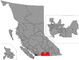
The Similkameen Country, also referred to as the Similkameen Valley or Similkameen District, but generally referred to simply as The Similkameen or more archaically, Similkameen, is a region roughly coinciding with the basin of the river of the same name in the Southern Interior of British Columbia. The term "Similkameen District" also refers to the Similkameen Mining District, a defunct government administrative district, which geographically encompasses the same area, and in more casual terms may also refer to the Similkameen electoral district, which was combined with the Grand Forks-Greenwood riding by the time of the 1966 election. The Similkameen Country has deep historical connections to the Boundary Country and the two are sometimes considered one region, partly as a result of the name of the electoral district. It is also sometimes classed as being part of the Okanagan region, which results from shared regional district and other administrative boundaries and names. The term "Similkameen District" may also historically refer to the Similkameen Division Yale Land District, which also includes Osoyoos and the Boundary Country to Osoyoos' east.
Boat Encampment is a ghost town in the East Kootenay region of southeastern British Columbia. The locality was at the tip of the Big Bend on the north shore of the Columbia River. The general vicinity, on the former Big Bend Highway, was by road about 151 kilometres (94 mi) northwest of Golden and 159 kilometres (99 mi) north of Revelstoke.

Rock Creek is a settlement in the Boundary Country region of south central British Columbia. The unincorporated settlement is mostly on the southwest side of the Kettle River at the confluence with Rock Creek. The place lies at the junction of BC Highway 33, and BC Highway 3.
Wild Horse River is a tributary of the Kootenay River in the East Kootenay region of southeastern British Columbia. The river flows southwest from the Canadian Rockies to the mouth, which lies immediately south of Fort Steele.
Carmi is a hamlet in the Boundary Country region of southern British Columbia. The town is on the west side of the West Kettle River, east of Penticton, on Hwy 33. Carmi emerged as a silver mining camp just after the turn of the 20th century, named after the nearby mine owned by James C. Dale from Carmi, Illinois.
Ferguson is an unincorporated community in the West Kootenay region of southeastern British Columbia. The near ghost town is immediately northwest of the confluence of Ferguson Creek into Lardeau Creek. The locality, on Ferguson Rd and off BC Highway 31, is by road about 183 kilometres (114 mi) north of Nelson and 96 kilometres (60 mi) by road and ferry southeast of Revelstoke.
Niagara is on the west side of the Granby River, near the junction with Fisherman Creek, in the Boundary Country region of south central British Columbia. The small community is about 12 kilometres (7 mi) north of Grand Forks on North Fork Rd.