
Indonesia is an archipelagic country located in Southeast Asia, lying between the Indian Ocean and the Pacific Ocean. It is located in a strategic location astride or along major sea lanes connecting East Asia, South Asia and Oceania. Indonesia is the largest archipelago in the world. Indonesia's various regional cultures have been shaped—although not specifically determined—by centuries of complex interactions with its physical environment.

Sumatra is one of the Sunda Islands of western Indonesia. It is the largest island that is fully within Indonesian territory, as well as the sixth-largest island in the world at 475,807.63 km2 (182,812 mi.2), including adjacent islands such as the Simeulue, Nias, Mentawai, Enggano, Riau Islands, Bangka Belitung and Krakatoa archipelago.

Nias is an island located off the western coast of Sumatra, Indonesia. Nias is also the name of the archipelago of which the island is the centre, but also includes the Batu Islands to the south-east and the small Hinako Islands to the west. Nias Island covers an area of 5,625.0 km2 (2,171.8 sq mi). It is mostly a lowland area rising to around 800 m (2,600 ft) above sea level. There were 756,338 inhabitants on the island at the 2010 Census; at the 2015 Intermediate Census this had risen to 798,506 and the 2020 Census resulted in a total of 880,550. The official estimate as at mid 2022 was 902,632.

Simeulue Regency is a regency in the Aceh special region of Indonesia. It occupies the whole island of Simeulue, 150 km off the west coast of Sumatra, with an area of 1,838.09 square kilometres. It had a population of 80,674 at the 2010 census and 92,865 at the 2020 census; the official estimate as at mid 2022 was 94,876.

Indonesia was the first country to be seriously affected by the earthquake and tsunami created by the 2004 Indian Ocean earthquake on 26 December 2004, swamping the northern and western coastal areas of Sumatra, and the smaller outlying islands off Sumatra. Nearly all the casualties and damage took place within the province of Aceh. The time of arrival of the tsunami was between 15 and 30 minutes after the deadly earthquake. According to the country's National Disaster Relief Coordination Agency, around 130,000 people were dead and 37,063 were missing. In addition, the UN estimated that 655,000 people were homeless and sheltering in scattered refugee camps across the province.
The 2005 Nias–Simeulue earthquake occurred on 28 March off the west coast of northern Sumatra, Indonesia. At least 915 people were killed, mostly on the island of Nias. The event caused panic in the region, which had already been devastated by the massive tsunami triggered by the 2004 Indian Ocean earthquake, but this earthquake generated a relatively small tsunami that caused limited damage. It was the third most powerful earthquake since 1965 in Indonesia.
Teluk Dalam is a town and district in the South Nias Regency, North Sumatra province, Indonesia. Following the splitting off of parts of the original district to form new districts, it is now mainly confined to the town, and its area is now 41.30 km2 (15.95 sq mi). In English, Teluk Dalam means "Deep Bay". As of mid 2021, Telukdalam had a population of 25,780 and a population density of 624.2/km2. Telukdalam has various tourist sites, such as Sorake Beach, Lagundri Beach and Bawömataluo which hosts Nias traditional houses of hundred years ago.

The Banyak Islands are a group of inhabited islands located between Simeulue and Nias off the western coast of Sumatra in Indonesia's Aceh Province. Surveys of the area approximate around 71 islands and additional mangrove stands in shallow off-shore areas, although locals count 99 islands. The largest island in the group is Tuangku, with the principal town of Haloban. Two other major islands located either side of Tuangku are Bangkaru and Ujung Batu. Tuangku is separated from Bangkaru by a fault line.

Simeulue is an island of Indonesia, 150 kilometres (93 mi) off the west coast of Sumatra. It covers an area of 1,754 square kilometres, including minor offshore islands. It had a population of 80,674 at the 2010 census and 92,865 at the 2020 census. The official estimate as at mid 2021 was 93,762. Its capital is Sinabang.

The September 2007 Sumatra earthquakes were a series of megathrust earthquakes that struck the Sunda Trench off the coast of Sumatra, Indonesia, with three of magnitude 7 or greater. A series of tsunami bulletins was issued for the area. The most powerful of the series had a magnitude of 8.5, which makes it in the top 20 of the largest earthquakes ever recorded on a seismograph.
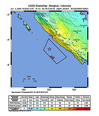
The 2000 Enggano earthquake struck at 23:28 local time on June 4 with a moment magnitude of 7.9 and a maximum Mercalli intensity of VI (Strong). The event occurred off the coast of southern Sumatra, Indonesia near Enggano Island. There were more than 100 fatalities and up to 2,585 injuries. Over 730 aftershocks shook the area afterwards, one just eleven minutes after the mainshock.
The Sigulai language is an Austronesian language spoken on Simeulue island off the western coast of Sumatra in Indonesia. It belongs to the Malayo-Polynesian branch of the Austronesian languages. Sikule is one of Northwest Sumatra–Barrier Islands languages, which are a sub-group of Western Malayo-Polynesian.
The Simeulue language is spoken by the Simeulue people of Simeulue off the western coast of Sumatra, Indonesia.
Lasikin Airport is an airport in Sinabang, Simeulue island, Aceh, Indonesia. The airport was damaged by the 2004 tsunami and destroyed by the 2005 Nias–Simeulue earthquake. It was reopened on 1 November 2007 following 45 billion rupiah of spending by the Aceh-Nias recovery agency with control tower and enlarged runway facilitating larger turboprop aircraft.

The April 2010 Sumatra earthquake occurred on with a moment magnitude of 7.8 and a maximum Mercalli intensity of V (Moderate). The shock occurred near the Banyak Islands, off the island of Sumatra in Indonesia. A tsunami watch was issued according to the Pacific Tsunami Warning Center in Honolulu which was later canceled. A 40 cm surge was reported in the Banyak Islands an hour after the quake, along with 62 injuries. Power outages were reported throughout the province of North Sumatra as well as in Aceh. This quake is one in a sequence of large earthquakes along the Sunda megathrust in the 2000s.
Babi Island is an island located in Aceh, Indonesia.
The 2012 Indian Ocean earthquakes were magnitude 8.6 and 8.2 Mw undersea earthquakes that struck near the Indonesian province of Aceh on 11 April at 15:38 local time. Initially, authorities feared that the initial earthquake would cause a tsunami and warnings were issued across the Indian Ocean; however, these warnings were subsequently cancelled. These were unusually strong intraplate earthquakes and the largest strike-slip earthquake ever recorded.

The Simeulue people are an indigenous group of people inhabiting Simeulue Island off the west coast of Sumatra, Indonesia. They are mostly found in Teupah Barat, Simeulue Timur, Simeulue Tengah, Teupah Selatan and Teluk Dalam districts. The Simeulue people speak Simeulue, a Northwest Sumatra–Barrier Islands language closely related to Sikule and Nias. The language also has a strong Acehnese and Malay influence.

On February 20, 2008, an earthquake with a moment magnitude of 7.4 struck off the coast of Sumatra at a hypocentre depth of 26 km. The earthquake had an epicenter located on the island of Simeulue, northwest from Sinabang, a small town on the island. Three people were killed and an additional 25 seriously injured as a result of the earthquake.
