Related Research Articles

The Delmarva Peninsula, or simply Delmarva, is a large peninsula on the East Coast of the United States, occupied by the vast majority of the state of Delaware and parts of the Eastern Shore regions of Maryland and Virginia. The peninsula is 170 miles (274 km) long. In width, it ranges from 70 miles (113 km) near its center, to 12 miles (19 km) at the isthmus on its northern edge, to less near its southern tip of Cape Charles. It is bordered by the Chesapeake Bay on the west, and the Delaware River, Delaware Bay, and the Atlantic Ocean on the east.

Worcester County is the easternmost county of the U.S. state of Maryland. As of the 2010 census, the population was 51,454. Its county seat is Snow Hill. It is the only county of Maryland that borders the Atlantic Ocean, and the only county bordering both Delaware and Virginia. The county was named for Mary Arundell, the wife of Sir John Somerset, a son of Henry Somerset, 1st Marquess of Worcester. She was sister to Anne Arundell, wife of Cecil Calvert, 2nd Baron Baltimore, the first Proprietor and Proprietary Governor of the Province of Maryland.

Berlin is a town in Worcester County, Maryland, United States which includes its own historical Berlin Commercial District. The population was 4,485 at the 2010 census, and has since grown in population. It is part of the Salisbury, Maryland-Delaware Metropolitan Statistical Area.

Ocean City, officially the Town of Ocean City, is an Atlantic resort town in Worcester County, Maryland, United States. Ocean City is a major beach resort area along the East Coast of the United States. The population was 7,102 at the 2010 U.S. census, although during summer weekends the city hosts between 320,000 and 345,000 vacationers, and up to 8 million visitors annually. During the summer, Ocean City becomes the second most populated municipality in Maryland, after Baltimore. Located on Fenwick Island, it is part of the Salisbury, MD-DE Metropolitan Statistical Area, as defined by the United States Census Bureau.

West Ocean City is a census-designated place (CDP) in Worcester County, Maryland, United States. The population was 4,375 at the 2010 census. It is part of the Salisbury, Maryland-Delaware Metropolitan Statistical Area.

The Eastern Shore of Maryland is a part of the U.S. state of Maryland that lies mostly on the east side of the Chesapeake Bay and consists of nine counties, seven of which have Chesapeake Bay coastlines. The region also contains Maryland's only coast along the Atlantic Ocean.

Assateague Island is a 37-mile (60 km) long barrier island located off the eastern coast of the Delmarva Peninsula facing the Atlantic Ocean. The northern two-thirds of the island is in Maryland while the southern third is in Virginia. The Maryland section contains the majority of Assateague Island National Seashore and Assateague State Park. The Virginia section contains Chincoteague National Wildlife Refuge and a one-mile stretch of land containing the lifeguarded recreational beach and interpretive facilities managed by the National Park Service. It is best known for its herds of feral horses, pristine beaches and the Assateague Lighthouse. The island also contains numerous marshes, bays, and coves, including Toms Cove. Bridge access for cars is possible from both Maryland and Virginia, though no road runs the full north/south length of the island.

Assateague Island National Seashore is a unit of the National Park Service system of the U.S. Department of the Interior. Located on the East Coast along the Atlantic Ocean in Maryland and Virginia, Assateague Island is the largest natural barrier island ecosystem in the Middle Atlantic states region that remains predominantly unaffected by human development. Located within a three-hour drive to the east and south of Richmond, Washington, Baltimore, Wilmington, Philadelphia major metropolitan areas plus north of the several clustered smaller cities around Hampton Roads harbor of Virginia with Newport News, Hampton, Norfolk, Portsmouth, Chesapeake and Virginia Beach. The National Seashore offers a setting in which to experience a dynamic barrier island and to pursue a multitude of recreational opportunities. The stated mission of the park is to preserve and protect “unique coastal resources and the natural ecosystem conditions and processes upon which they depend, provide high-quality resource-based recreational opportunities compatible with resource protection and educate the public as to the values and significance of the area”.

Assateague State Park is a public recreation area in Worcester County, Maryland, USA,, located at the north end of Assateague Island, a barrier island bordered by the Atlantic Ocean on the east and Sinepuxent Bay on the west. The state park is bordered on both its north and south sides by Assateague Island National Seashore and is reached via the Verrazano Bridge which carries Maryland Route 611 across Sinepuxent Bay. The park offers wildlife viewing, beach activities, and camping facilities. It is managed by the Maryland Park Service of the larger Maryland Department of Natural Resources with the support of volunteers working under the auspices of the non-profit Friends of Assateague State Park.

Sinepuxent Bay is an inland waterway which connects Chincoteague Bay to Isle of Wight Bay, and is connected to the Atlantic Ocean via the Ocean City Inlet. It separates Sinepuxent Neck, in Worcester County, Maryland from Assateague Island, and West Ocean City, Maryland from downtown Ocean City. Islands in the Sinepuxent Bay include Horn Island and Skimmer Island. It is crossed by the Harry W. Kelley Memorial Bridge on U.S. Route 50 and the Verrazano Bridge on Maryland Route 611. The bay is the location of the islands that compose the Sinepuxent Bay Wildlife Management Area. Historically the area was referred to by various names including Sinepuxent, Sene Puxon, Synepuxent, Cinnepuxon, et al.

Maryland Route 611 is a state highway in the U.S. state of Maryland. Known as Stephen Decatur Highway, the state highway runs 8.51 miles (13.70 km) from Assateague Island north to U.S. Route 50 in West Ocean City. MD 611 is named for Stephen Decatur, the U.S. naval officer of the early 19th century who was born in nearby Berlin. The state highway provides access to Assateague State Park and Assateague Island National Seashore via the Verrazano Bridge named for Giovanni da Verrazzano. MD 611 was first paved in West Ocean City in the mid-1930s. The highway was extended south to MD 376 at Lewis Corner in the 1940s. A ferry crossed Sinepuxent Bay to Assateague Island from the southern end of the county highway that continued south from Lewis Corner until MD 611 was extended across the Verrazano Bridge in the mid-1960s.
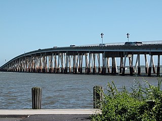
The Verrazano Bridge in Maryland is a bridge on Maryland Route 611 over Sinepuxent Bay that connects Assateague Island to the mainland.

Maryland Route 376 is a state highway in the U.S. state of Maryland. Known for most of its length as Assateague Road, the state highway runs 4.56 miles (7.34 km) from MD 818 in Berlin east to MD 611 at Lewis Corner. MD 376 connects Berlin with communities on the Sinepuxent Neck and, in conjunction with MD 611, connects Berlin with Assateague Island National Seashore. The state highway was constructed from Berlin in the second half of the 1920s and the early 1930s.

Chincoteague Bay is a lagoon between the Atlantic barrier islands of Assateague and Chincoteague and the mainland of Worcester County, Maryland and northern Accomack County, Virginia. At the bay's northern end, where it narrows between Assateague and Sinepuxent Neck, it becomes Sinepuxent Bay; Chincoteague Bay's southern end drains into the Atlantic Ocean via Queen Sound and Chincoteague Inlet. No major river flows into Chincoteague Bay—its largest tributaries are Newport Creek in Worcester County and Swans Gut Creek in Accomack County.
Sinepuxent Bay Wildlife Management Area is a state wildlife management area (WMA) of Maryland that consists of several islands in Sinepuxent Bay, Isle of Wight Bay, and Chincoteague Bay in Worcester County.
The Battle of Cockle Creek, October 5, 1861, was a minor naval engagement off Chincoteague, Virginia early in the American Civil War.

Fenwick Island is a barrier island along the Atlantic Ocean in Delaware and Maryland in the United States. It contains the communities of South Bethany and Fenwick Island in Delaware along with Ocean City, Maryland. Until 1933, it was attached to Assateague Island to the south. That year, a hurricane carved an inlet between the two landforms, which was made permanent. If not for the Assawoman Canal, constructed by the U.S. Army Corps of Engineers in 1891, the island would be attached to the mainland of Delaware.
Dog and Bitch Island is depending on the sources one or two islands in Worcester County, Maryland, in the United States. It is located within the Isle of Wight Bay. The island is small in size and marshy. In 2014 the federal Army Corps of Engineers pumped 18,000 cubic yards of material from navigation channel dredging operations onto the island to improve migratory bird habitat.

Rackliffe House is a restored 18th-century coastal plantation house overlooking Sinepuxent Bay. The house is located at 11700 Tom Patton Lane, Berlin, Maryland, 21811, within walking distance of the Assateague Island Visitor Center at Assateague State Park, Maryland. Built of Flemish bond brick with random glazed headers, the house would have been "one of the most impressive gentry dwellings in the region" in the 18th century. The plantation house is one of a small number of remaining tidewater dwellings from colonial times, and may be the only one of its kind and vintage in the Mid-Atlantic region that is open to the public.
Ilia Fehrer was an environmentalist and member of the Maryland Women's Hall of Fame most widely known for fighting to preserve Assateague Island, Chincoteague Bay, and other Chesapeake Bay coastal regions from destructive urban development.
References
Coordinates: 38°18′47″N75°09′07″W / 38.31306°N 75.15194°W