Sinzing

Last updated
Sinzing
Gaststaette Roehrl Eilsbrunn.jpg
DEU Sinzing COA.svg
Location of Sinzing within Regensburg district
Sinzing in R.svgForstmühler ForstKreuther ForstBrunnBrunnWiesentWolfsegg
Germany adm location map.svg
Red pog.svg
Sinzing
Bavaria location map.svg
Red pog.svg
Sinzing
Coordinates: 48°59′28″N12°02′05″E / 48.99111°N 12.03472°E / 48.99111; 12.03472
Country Germany
State Bavaria
Admin. region Oberpfalz
District Regensburg
Subdivisions24 Ortsteile
Government
   Mayor (202026) Patrick Grossmann [1] (CSU)
Area
  Total44.30 km2 (17.10 sq mi)
Elevation
338 m (1,109 ft)
Population
 (2022-12-31) [2]
  Total7,576
  Density170/km2 (440/sq mi)
Time zone UTC+01:00 (CET)
  Summer (DST) UTC+02:00 (CEST)
Postal codes
93161
Dialling codes 0941, 09404
Vehicle registration R
Website www.sinzing.de

Sinzing is a municipality in the district of Regensburg in Bavaria in Germany.

Contents

Geography

Sinzing is located on the Schwarzen Laber and the Danube, about eight kilometers west of Regensburg.

Municipality structure

There are 17 districts

Adlstein Alling Bergmatting Bruckdorf Dürnstetten Eilsbrunn Grafenried Hart (PLZ 93152) Kleinprüfening Kohlstadt Kühblöß Mariaort Minoritenhof Niederviehhausen Oberalling Reichenstetten Riegling Saxberg Schneckenbach Sinzing Steg Thalhof Unteralling Viehhausen Vogelsang Waltenhofen Zeiler (PLZ 93152)

History

Sinzing first appeared in historical records in 921. In 1031, the part known as Eilsbrunn was mentioned. This part was, however, almost completely destroyed during the Thirty Years' War. The fortifications in Niederviehhausen were also destroyed; only a tower is still visible. From 1145 until 1966, it was possible to cross the Danube at Sinzing, and until 1485, Sinzing was part of the trade route between Regensburg and Nürnberg. Wine was cultivated in Sinzing up until the 17th century. In the 19th century Sinzing had many mills, some paper factories and a tobacco factory.

The modern district was created in 1972 by the incorporation of the previously independent districts of Sinzing, Viehhausen, Eilsbrunn, and Bergmatting. The Gaststätte Röhrl, the oldest continuously operated restaurant in the world, is located in Eilsbrunn.

Culture and sights

Architectural engineering

Pilgrimage Church Mariaort: The town of Ort was first mentioned in a document in 1020. The church dates from 1192. It was looted in the Thirty Years War, expanded in 1774–1776 and badly damaged in World War II. Early classical high altar, side altars from 1650. The juniper bush on the pulpit on the outside of the church symbolizes that the miraculous image should have swum on a juniper bush from the Black Sea to Mariaort.

Oberviehhausen Castle: The small castle was first mentioned in a document in 1435, it changed hands several times over the centuries. It was destroyed by the Swedes during the Thirty Years War and only rebuilt in 1697. The castle building is now used as a rectory.

Castle ruin Niederviehhausen: The castle was destroyed by the Swedes during the Thirty Years War. Today only the six-story, 22-meter-high tower made of humpback ashlar remains.

Old church in Sinzing: Church with Romanesque frescoes from 1145. The building with the massive tower with pyramid roof probably dates from the 13th or 14th century. The furnishings are baroque.

Bruckdorf Church: mainly from the 11th century.

Röhrl restaurant in Eilsbrunn: Family-owned since 1658 and, according to the Guinness Book of Records, the oldest continuously operated restaurant in the world

Related Research Articles

<span class="mw-page-title-main">Abensberg</span> Town in Bavaria, Germany

Abensberg is a town in the Lower Bavarian district of Kelheim, in Bavaria, Germany, lying around 30 km (19 mi) southwest of Regensburg, 40 km (25 mi) east of Ingolstadt, 50 km (31 mi) northwest of Landshut and 100 km (62 mi) north of Munich. It is situated on the river Abens, a tributary of the Danube.

<span class="mw-page-title-main">Friedberg, Bavaria</span> Town in Bavaria, Germany

Friedberg is a town in the district Aichach-Friedberg, Bavaria, Germany, with some 30,000 inhabitants. It is located next to Augsburg at the river Lech. The town was founded in the 13th century in order to collect a toll from people using the bridge across the Lech.

<span class="mw-page-title-main">Bornhagen</span> Municipality in Thuringia, Germany

Bornhagen is a municipality in the district of Eichsfeld in Thuringia, Germany, located at the foot of the ruins of Hanstein Castle. The town district Rimbach is positioned directly south of the castle citadel at an elevation of 370 m. Bornhagen is located 22 km south of Göttingen, 85 km northwest of the state capital Erfurt and 270 km southwest of Berlin. It is the westernmost settlement in Thuringia but does not contain the westernmost point which is 75 km south near Geisa.

<span class="mw-page-title-main">Donauwörth</span> Town in Bavaria, Germany

Donauwörth is a town and the capital of the Donau-Ries district in Swabia, Bavaria, Germany. It is said to have been founded by two fishermen where the rivers Danube (Donau) and Wörnitz meet. The city is part of the scenic route called "Romantische Straße".

<span class="mw-page-title-main">Straubing</span> Town in Bavaria, Germany

Straubing is an independent city in Lower Bavaria, southern Germany. It is seat of the district of Straubing-Bogen. Annually in August the Gäubodenvolksfest, the second largest fair in Bavaria, is held.

<span class="mw-page-title-main">Deggendorf</span> Town in Bavaria, Germany

Deggendorf is a town in Bavaria, Germany, capital of the Deggendorf district.

<span class="mw-page-title-main">Stamsried</span> Municipality in Bavaria, Germany

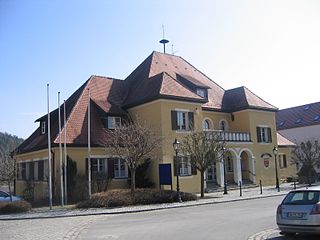
Stamsried is a village and municipality in the district of Cham in the Upper Palatinate region of Bavaria, Germany, near the Czech border. It is also located in the Roman Catholic diocese of Regensburg. Stamsried has a population of 2,319 as of June 2004 and an area of 4,343 hectares which includes surrounding countryside outside the built up area of the village itself, the population density is 53.4 persons per square kilometer. Stamsried is located 456 meters above sea level and contains rolling hills as high as 600 meters.

<span class="mw-page-title-main">Neuburg an der Donau</span> Town in Bavaria, Germany

Neuburg an der Donau is a town which is the capital of the Neuburg-Schrobenhausen district in the state of Bavaria in Germany.

<span class="mw-page-title-main">Roth, Bavaria</span> Town in Bavaria, Germany

Roth is a town in Bavaria, Germany, the capital of the Roth District. It is located about 25 km south of Nuremberg.

<span class="mw-page-title-main">Cham, Germany</span> Town in Bavaria, Germany

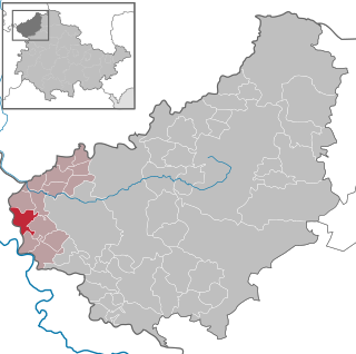
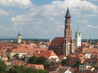
Cham is the capital of the district of Cham in the Upper Palatinate in Bavaria in Germany.

<span class="mw-page-title-main">Donaustauf</span> Municipality in Bavaria, Germany

Donaustauf is a market town in Bavaria, 5 km (3 mi) east of Regensburg at the foothills of the Bavarian Forest. The ruins of a medieval castle, presumably erected between 914 and 930, tower above the small town. Situated nearby on a hill rising from the Danube is the imposing Teutonic temple of fame, Walhalla, a costly reproduction of the Parthenon in Athens. The Walhalla was commissioned by Ludwig I, King of Bavaria, and inaugurated on 18 October 1842.

<span class="mw-page-title-main">Rimbach, Upper Palatinate</span> Municipality in Bavaria, Germany

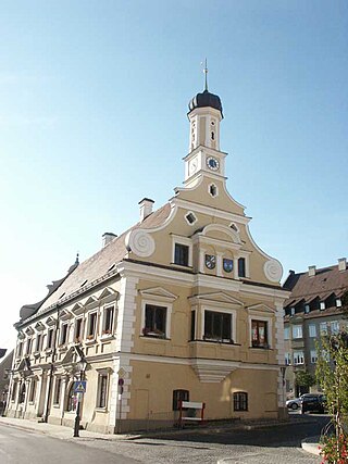
Rimbach is a municipality in the district of Cham (district) in the Upper Palatinate in Bavaria in Germany.

<span class="mw-page-title-main">Rain, Swabia</span> Municipality in Bavaria, Germany

Rain is a town in the Donau-Ries district, in Bavaria, Germany. It is situated on the river Lech, close to its confluence with the Danube, 11 km east of Donauwörth.

<span class="mw-page-title-main">Velburg</span> Town in Bavaria, Germany

Velburg is a town in the district of Neumarkt in Bavaria, Germany. It is situated 17 km southeast of Neumarkt in der Oberpfalz, and 39 km northwest of Regensburg.

<span class="mw-page-title-main">Wallenfels</span> Town in Bavaria, Germany

Wallenfels is a town in the district of Kronach, in Bavaria, Germany. It is situated in the Franconian Forest, 11 km east of Kronach, and 32 km west of Hof.

<span class="mw-page-title-main">Langenbach, Bavaria</span> Municipality in Bavaria, Germany

Langenbach is a municipality in the district of Freising in Bavaria in Germany.

<span class="mw-page-title-main">Offingen</span> Municipality in Bavaria, Germany

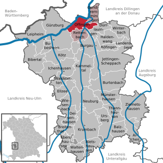
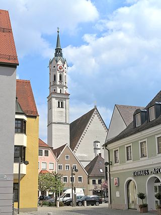
Offingen is a municipality in the Swabian administrative district Günzburg in Bavaria in Germany.

<span class="mw-page-title-main">Neufahrn in Niederbayern</span> Municipality in Bavaria, Germany

Neufahrn i. NB or Neufahrn in Niederbayern is a municipality in the district of Landshut in Bavaria in Germany. Its Bavarian name is Neifing.

<span class="mw-page-title-main">Lupburg</span> Municipality in Bavaria, Germany

Lupburg is a municipality in the district of Neumarkt in Bavaria in Germany.

<span class="mw-page-title-main">Gaststätte Röhrl</span>

The Gaststätte Röhrl is a restaurant with beer garden in Eilsbrunn in the district of Regensburg, Germany. Since 1658 it is continuously operated and owned by the Röhrl family.

References