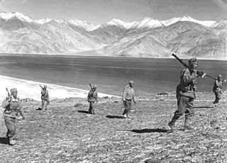
The Sino-Indian War also known as Indo-China War, Indo-China War of 1962 or Sino-Indian War of 1962, took place between China and India from October to November 1962. It was a military escalation of the Sino-Indian border dispute. Fighting occurred along India's border with China, in India's North-East Frontier Agency east of Bhutan, and in Aksai Chin west of Nepal.

The Line of Actual Control (LAC), in the context of the Sino-Indian border dispute, is a notional demarcation line that separates Indian-controlled territory from Chinese-controlled territory. The concept was introduced by Chinese premier Zhou Enlai in a 1959 letter to Jawaharlal Nehru as the "line up to which each side exercises actual control", but rejected by Nehru as being incoherent. Subsequently, the term came to refer to the line formed after the 1962 Sino-Indian War.
The Sino-Indian border dispute is an ongoing territorial dispute over the sovereignty of two relatively large, and several smaller, separated pieces of territory between China and India. The first of the territories, Aksai Chin, is administered by China as part of the Xinjiang Uygur Autonomous Region and Tibet Autonomous Region and claimed by India as part of the union territory of Ladakh; it is mostly uninhabited high-altitude wasteland in the larger regions of Kashmir and Tibet and is crossed by the Xinjiang-Tibet Highway, but with some significant pasture lands at the margins. The other disputed territory is south of the McMahon Line, in the area formerly known as the North-East Frontier Agency and now called Arunachal Pradesh which is administered by India. The McMahon Line was part of the 1914 Simla Convention signed between British India and Tibet, without China's agreement. China disowns the agreement, stating that Tibet was never independent when it signed the Simla Convention.

Daulat Beg Oldi is a traditional campsite and current military base located in the midst of the Karakoram Range in northern Ladakh, India. It is on the historic trade route between Ladakh and the Tarim Basin, and is the last campsite before the Karakoram Pass. It is said to be named after Sultan Said Khan, who died here on his return journey from an invasion of Ladakh and Kashmir. Chip Chap River, the main headwater of the Shyok River, flows just to the south. The Line of Actual Control with Chinese-controlled Aksai Chin is five miles to the east.
The Depsang Plains, a high-altitude gravelly plain in the northwest portion of the disputed Aksai Chin region of Kashmir, divided into Indian and Chinese administered portions by a Line of Actual Control. India controls the western portion of the plains as part of Ladakh, while the eastern portion is controlled by China and claimed by India. The Line of Control with Pakistan-administered Gilgit-Baltistan is 80 kilometres (50 mi) west of the Depsang Plains with the Siachen Glacier in-between. Ladakh's traditional trade route to Central Asia passed through the Depsang Plains, with the Karakoram Pass lying directly to its north.
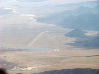
Fukche Advanced Landing Ground is an airfield in the Demchok sector of the union territory of Ladakh, India. It was built shortly before the 1962 Sino-Indian War and was revived in 2008. It is located adjacent to Koyul, 34 km northwest of Demchok.
Chushul is a village in the Leh district of Ladakh, India. It is located in the Durbuk tehsil, in the area known as "Chushul Valley", south of the Pangong Lake and west of the Spanggur Lake. The Line of Actual Control with China runs about 5 miles east of Chushul, across the Chushul Valley. Famous as site for historical battle grounds.
The Kongka Pass or Kongka La is a low mountain pass on the Line of Actual Control between India and China in eastern Ladakh. It lies on a spur of the Karakoram range that intrudes into the Chang Chenmo Valley adjacent to the disputed Aksai Chin region. China claimed the location as its border in a 1956 map, and attacked an Indian patrol party in 1959 killing ten policemen and apprehending ten others. Known as the Kongka Pass incident, the event was a milestone in the escalation of the border dispute between the two countries.
Chepzi, also spelt Chabji and Dripuche, is a village and military post in Tsamda County of Tibet in China, close to the border with India's Ladakh. Chepzi is close to Chumar in Ladakh's Rupshu region. There is evidence that the people of Chumar have traditionally used the farmlands in Chepzi, and the village was included in Ladakh during the British Raj. However, independent India excluded it from its border definition. The border has been witness to a large number of incursions by the Chinese People's Liberation Army since 2011.

The 2013 Depsang standoff, also called 2013 Depsang incursion, or 2013 Daulat Beg Oldi incident, was an incursion and sit-in by a platoon-sized contingent of the Chinese PLA in the dry river bed of Raki Nala, in the Depsang Bulge area, 30 km south of Daulat Beg Oldi near the Line of Actual Control (LAC) in the disputed Aksai Chin region. Indian forces responded to the Chinese presence by quickly establishing their own encampment 300 metres (980 ft) away. Negotiations between China and India lasted nearly three weeks, during which the Chinese position was supplied by trucks and supported by helicopters. The dispute was resolved on 5 May, after which both sides withdrew. As part of the resolution, the Indian military agreed to refrain from constructing bunkers 250 km away in the Chumar sector, which the Chinese perceived as threatening. The Chinese military in July 2014 acknowledged the incursion at the Depsang Valley in Ladakh region and said that such incidents occurred due to differing perceptions of the Line of Actual Control.
The Galwan River flows from the disputed Aksai Chin area administered by China to the Union Territory of Ladakh, India. It originates near the caravan campsite Samzungling on the eastern side of the Karakoram range and flows west to join the Shyok River. The point of confluence is 102 km south of Daulat Beg Oldi. Shyok River itself is a tributary of the Indus River, making Galwan a part of the Indus River system.
The Chip Chap River is a tributary of the Shyok River that flows from the disputed Aksai Chin region administered by China to Ladakh in India. It originates at the eastern edge of the Depsang Plains and flows west, skirting around the Depsang Plains in the north. It discharges into the Shyok River, forming one of the upstream tributaries of the Indus River.
Chumar or Chumur is a village and the centre of nomadic grazing region located in south-eastern Ladakh, India. It is in Rupshu block, south of the Tso Moriri lake, on the bank of the Parang River, close to Ladakh's border with Tibet. Since 2012, China has disputed the border in this area, though the Chumur village itself is undisputed.
Demchok , previously called New Demchok, and called Parigas by the Chinese, is a village and military encampment in the Indian-administered Demchok sector that is disputed between India and China. It is administered as part of the Nyoma tehsil in the Leh district of Ladakh by India, and claimed by China as part of the Tibet Autonomous Region.

Border Personnel Meeting points are locations along the disputed Sino-Indian territories on Line of Actual Control (LAC) where the armies of both countries hold ceremonial and practical meetings to resolve border issues and improve relations. While border meetings have been held since the 1990s, the first formal Border Personnel Meeting point was established in 2013. There are five meeting points: two in the Indian Union Territory of Ladakh, one in Sikkim, and two in Arunachal Pradesh in India's Central and Eastern sectors.

Beginning on 5 May 2020, Chinese and Indian troops engaged in aggressive melee, face-offs, and skirmishes at locations along the Sino-Indian border, including near the disputed Pangong Lake in Ladakh and the Tibet Autonomous Region, and near the border between Sikkim and the Tibet Autonomous Region. Additional clashes also took place at locations in eastern Ladakh along the Line of Actual Control (LAC).
The Darbuk–Shyok–DBO Road, also called the Sub-Sector North Road, is a strategic all-weather road in eastern Ladakh in India, close to the Line of Actual Control with China. It connects Ladakh's capital city Leh, via the villages of Darbuk and Shyok at southern Shyok River Valley, with the Daulat Beg Oldi (DBO) post near the northern border. The 220-km long section between Shyok and DBO was constructed between 2000 and 2019 by India's Border Roads Organisation (BRO). The DS-DBO Road has reduced the travel time between Leh to DBO from 2 days to 6 hours. In January 2023, BRO announced that it is constructing the DSDBO tunnel on this route.
The Depsang Bulge or Burtsa Bulge is a 900-square-kilometre area of mountain terrain in the disputed Aksai Chin region, which was conceded to India by China in 1960, but has remained under Chinese occupation since the 1962 Sino-Indian War. The area is immediately to the south of the Depsang Plains and encloses the basin of the Burtsa Nala, a stream originating in the Aksai Chin region and flowing west to merge with the Depsang Nala near the village of Burtsa in Ladakh, eventually draining into the Shyok River. The area is perceived to be of strategic importance to both the countries, sandwiched by strategic roads linking border outposts. Since 2013, China has made attempts to push the Line of Actual Control further west into Indian territory, threatening India's strategic road.
Gogra (also referred to as Nala Junction) is a pasture and campsite in the Ladakh union territory of India, near its disputed border with China. It is located in the Kugrang River valley, a branch valley of Chang Chenmo Valley, where the Changlung River flows into Kugrang. During the times of the British Raj, Gogra was a halting spot for travellers to Central Asia via the 'Chang Chenmo route', who proceeded through the Changlung river valley and the Aksai Chin plateau.
Jianan Pass is a border pass along the Line of Actual Control (LAC) between India and China, in the region of Ladakh and Aksai Chin. It is in the Chang Chenmo region, on the watershed between Kugrang and Galwan river basins. The Changlung river basin is also immediately to the east of the pass. China uses the name "Jianan Daban" for the pass. India does not have a native name, but refers to it as Patrol Point 15 (PP-15) for border security purposes. The term Hot Springs has also been used by Indian media through misapplication of terminology.


