
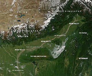
The Brahmaputra is a trans-boundary river which flows through Southwestern China, Northeastern India, and Bangladesh. It is known as Brahmaputra or Luit in Assamese, Yarlung Tsangpo in Tibetan, the Siang/Dihang River in Arunachali, and Jamuna River in Bengali. It is the 9th largest river in the world by discharge, and the 15th longest.

Pasighat is the headquarters of East Siang district in the Indian state of Arunachal Pradesh. Situated at the eastern foothills of the Himalayas at 155 metres (509 ft) above mean sea level, Pasighat is Arunachal's oldest town. The Government of India included Pasighat in the Smart Cities Mission development scheme in June 2017.

The Pahang River mainly flows through the state of Pahang, Malaysia. Its drainage basin covers its Pahang as well as the neighbouring state of Negeri Sembilan.
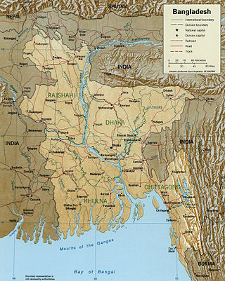
The Jamuna River is one of the three main rivers of Bangladesh. It is the lower stream of the Brahmaputra River, which originates in Tibet as Yarlung Tsangpo, before flowing through India and then southwest into Bangladesh. The Jamuna flows south and joins the Padma River (Pôdda), near Goalundo Ghat, before meeting the Meghna River near Chandpur. It then flows into the Bay of Bengal as the Meghna River.

The Jaldhaka River (Pron:/ˌdʒælˈdɑːkə/), also known as Dichu, is a tributary of the Brahmaputra and a trans-boundary river flowing through India, Bhutan and Bangladesh with a length of 233 kilometres. It originates from the Bitang Lake at Kupup, Gangtok District, Sikkim, near the Jelep La pass below Dongkya Mountain Range. It flows through Pakyong District of Sikkim, India and then passes through forests of Samtse District of Bhutan where it flows for around 40 kilometres and than re-enters India at Bindu, Kalimpong district. Further it passes through Neora Valley National Park, Chapramari Wildlife Sanctuary and Gorumara National Park in West Bengal along with cities and towns, like Paren, Gairibas, Jhalong, Dhupguri, Falakata, Mathabhanga and flows through Kalimpong, Jalpaiguri and Cooch Behar districts in West Bengal, India before entering Bangladesh at Mogolhat, Lalmonirhat District of Rangpur Division. It is known as Dharla River in Bangladesh and flows through towns like Kolaghat, Phulbari and Kurigram City and Passes southwards until the Dharla debouches into the Brahmaputra River at Bagua Anantpur of Kurigram District. Due to the river's wandering over several international borders, only a small length of the river lies in Bangladesh and Bhutan and most of its path lies in India. In some places, this river is also known as Mansai river and Singhimari river.

The geography of New York varies widely across the state. Most of New York is dominated by farms, forests, rivers, mountains, and lakes. New York's Adirondack Park is larger than any U.S. National Park in the contiguous United States. Niagara Falls, on the Niagara River as it flows from Lake Erie to Lake Ontario, is a popular attraction. The Hudson River begins near Lake Tear of the Clouds and flows south through the eastern part of the state without draining lakes George or Champlain. Lake George empties at its north end into Lake Champlain, whose northern end extends into Canada, where it drains into the Richelieu River and then the St. Lawrence. Four of New York City's five boroughs are on the three islands at the mouth of the Hudson River: Manhattan Island, Staten Island, and Brooklyn and Queens on Long Island.
This article discusses the geological origin, geomorphic characteristics, and climate of the northeastern Indian state of Assam. Extending from 89° 42′ E to 96° E longitude and 24° 8′ N to 28° 2′ N latitude, it has an area of 78,438 km2, similar to that of Ireland or Austria.

The Manas River, known in Bhutan as the Drangme Chhu, is a transboundary river in the Himalayan foothills between southern Bhutan, India, and China. It is the largest of Bhutan's four major river systems, with the other three being the Amo Chu or Torsa River, the Wang Chu or Raidak, and the Puna Tshang Chu or Sankosh. It is met by three other major streams before it again debouches into India in western Assam. The river flows for a total length of 400 kilometres (250 mi), including through Tibet for 24 km (15 mi), Bhutan for 272 kilometres (169 mi), and Assam for 104 kilometres (65 mi) before it joins the mighty Brahmaputra River at Jogighopa. A major tributary of the Manas, the Aie River, joins it in Assam at Bangpari.

Shitalakshya River is a distributary of the Brahmaputra. A portion of its upper course is known as Banar River or Banor River. In the Shitalakshya's initial stages, it flows in a southwest direction and then east of the city of Narayanganj in central Bangladesh until it merges with the Dhaleswari near Kalagachhiya. The river is about 110 kilometres (68 mi) long and at it widest, near Narayanganj, it is 300 metres (980 ft) across. Its flow, measured at Demra, has reached 74 cubic metres per second (2,600 cu ft/s). It remains navigable year round. The Shitalakshya flows through Gazipur district forming its border with Narsingdi for some distance and then through Narayanganj District.
The Kameng River in the eastern Himalayan mountains, originates in Tawang district from the glacial lake below snow-capped Gori Chen mountain 27°48′36″N92°26′38″E, elevation 6,300 metres (20,669 ft), on the India-Tibet border and flows through Bhalukpong circle of West Kameng District, Arunachal Pradesh and Sonitpur District of Assam, India. It becomes a braided river in its lower reaches and is one of the major tributaries of the Brahmaputra River, joining it at Tezpur, just east of the Kolia Bhomora Setu bridge.

Backergunge, Backergunje, Bakarganj, or Bakerganj was a former district of British India. It was the southernmost district of the Dacca Division. The district was located in the swampy lowlands of the vast delta of the Ganges and the Brahmaputra rivers.

The Subansiri is a trans-Himalayan river and a tributary of the Brahmaputra River that flows through Tibet's Lhuntse County in the Shannan Prefecture, and the Indian states of Arunachal Pradesh and Assam. The Subansiri is approximately 518 kilometres (322 mi) long, with a drainage basin 32,640 square kilometres (12,600 sq mi). It is the largest tributary of the Brahmaputra contributing 7.92% of the Brahmaputra's total flow.

Tuting is a town and headquarters of an eponymous circle in the Upper Siang district in Arunachal Pradesh, India. It is situated on the bank of Siang river (Brahmaputra) at a distance of 34 km (21 mi) south of Line of Actual Control and 170 km (110 mi) north of Yingkiong. Tuting is the center of an assembly constituency, and also home to an Indian Military headquarters. The border area reports frequent incursion attempts by the Chinese People's Liberation Army, including an attempt to construct a road in Indian territory.
Siang District is the 21st district of Arunachal Pradesh State, India. This district was created in 2015 by carving it out of the West Siang and East Siang districts of Arunachal Pradesh. The regions included in the district were the legislative assembly constituencies, 32-Rumgong and 35-Pangin.
Darna is a minor right-bank tributary of Godavari in the Nashik District, Maharashtra, India. Rising north of the Kalsubai range, it drains Igatpuri, Nashik and Niphad Talukas of Nashik District. The conjunction with Godavari is situated at Darnasangvi.
Pangin is a town in Siang district, for which it is the headquarters. Prior to the creation of the Siang district in 2015, the town had been in East Siang district.
Boleng is a town in Siang district, lying on the banks of Siang River in the Indian state of Arunachal Pradesh. It is the headquarters of the newly created Siang District, which was bifurcated from West Siang and East Siang. It is located about 100 km from Pasighat, East Siang district of Arunachal Pradesh. The district is named after the Brahmaputra, locally known as Siang.

The Champabati River is a tributary of the Brahmaputra River in the Indian state of Assam. The Champabati River has three sub tributaries - Bhur River, Lopani and Dhol pani which are originated from Bhutan hills.
