Cypress Peak is a mountain peak south of Brandywine Mountain on the Squamish-Cheakamus divide, west of Whistler in the New Westminster Land District of British Columbia, Canada. The mountain was named after nearby Cypress Creek.
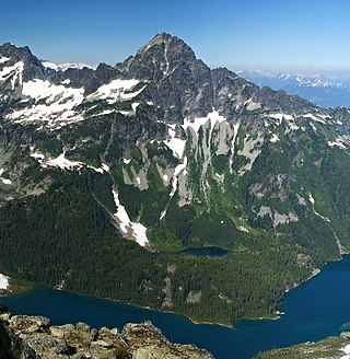
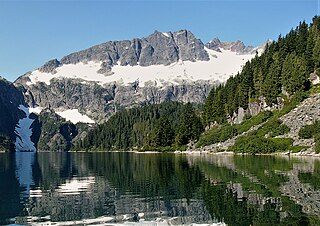
Alpha Mountain is a 2,302-metre (7,552-foot) summit located in the Tantalus Range, in Tantalus Provincial Park, in southwestern British Columbia, Canada. It is situated 14 km (9 mi) northwest of Squamish, and 4.6 km (3 mi) southeast of Mount Tantalus, which is the highest peak in the Tantalus Range. Its nearest higher peak is Serratus Mountain, 1.9 km (1 mi) to the west. The Serratus Glacier lies to the west of Alpha, unnamed glaciers lie on the northern and eastern slopes, and Lake Lovely Water lies below the south slope. Precipitation runoff from the peak drains into tributaries of the Squamish River.

Mount Niobe is a 2,021-metre (6,631-foot) summit located in the Tantalus Range, in Tantalus Provincial Park, in southwestern British Columbia, Canada. It is situated 10 km (6 mi) northwest of Squamish, and 7.2 km (4 mi) southeast of Mount Tantalus, which is the highest peak in the Tantalus Range. Its nearest higher peak is Lydia Mountain, 2.03 km (1 mi) to the west-northwest, and Omega Mountain lies 1.1 km (1 mi) to the east. Lake Lovely Water lies below the northern slope of the peak and precipitation runoff from the peak drains into tributaries of the Squamish River. The first ascent of the mountain was made in 1910 by E. Kingsford-Smith and G. Warren via the south side. The mountain's name was officially adopted on June 6, 1957, by the Geographical Names Board of Canada. The mountain was named for Niobe, daughter of Tantalus in Greek mythology, with several peaks in the Tantalus Range being named for family members of Tantalus.
Ossa Mountain is a 2,261-metre (7,418-foot) summit located in the Tantalus Range, in Tantalus Provincial Park, in southwestern British Columbia, Canada. It is situated 21 km (13 mi) northwest of Squamish, and 3.54 km (2 mi) north-northwest of Mount Tantalus, which is the highest peak in the Tantalus Range. Its nearest higher peak is Pelion Mountain, 0.77 km (0 mi) to the east. Unnamed glaciers lie on the northern and eastern slopes. Precipitation runoff from the peak drains into tributaries of the Squamish River and Clowhom River. The first ascent of the mountain was made on July 25, 1960, by Dick Chambers, Jack Bryan, and Howie Rode via the east ridge. The mountain names in the Tantalus Range have a Greek mythology theme, and Ossa Mountain was named for legendary Mount Ossa in Thessaly, upon which the Aloadaes are said to have attempted to pile Mount Pelion on top of Mount Ossa in their attempt to scale Olympus, home of the Greek gods. The mountain's name was officially adopted on June 6, 1957, by the Geographical Names Board of Canada.

Omega Mountain is a 1,918-metre (6,293-foot) summit located in the Tantalus Range, in Tantalus Provincial Park, in southwestern British Columbia, Canada. It is situated 10 km (6 mi) northwest of Squamish, and 8.2 km (5 mi) southeast of Mount Tantalus, which is the highest peak in the Tantalus Range. Its nearest higher peak is Mount Pelops, 1.7 km (1 mi) to the west. Lake Lovely Water lies below the northwestern slope of the peak with Alpha Mountain on the opposite side of the lake. Precipitation runoff from the peak drains into tributaries of the Squamish River. The first ascent of the mountain was made in 1916 by Tom Fyles and his brother, John Fyles. The mountain's name comes from Omega, in keeping with nearby peaks being named for Greek alphabet letters, namely Alpha and Iota mountains. Its name was officially adopted on June 6, 1957, by the Geographical Names Board of Canada.

Mount Dione is a 2,589-metre (8,494-foot) summit located in the Tantalus Range, in Tantalus Provincial Park, in southwestern British Columbia, Canada. It is situated 17 km (11 mi) northwest of Squamish, and 0.24 km (0 mi) north of Mount Tantalus, which is its nearest higher peak and the highest peak in the Tantalus Range. The Dione Glacier lies on the southern slope, and the Rumbling Glacier lies to the northeast. Precipitation runoff from the peak drains east into tributaries of the Squamish River, or west into tributaries of the Clowhom River. The first ascent of the mountain was made in 1916 by Tom Fyles and his brother, John Fyles, via the southeast ridge. The mountain names in the Tantalus Range have a Greek mythology theme, and Mount Dione was named for Dione, the wife of Tantalus. The mountain's name was submitted by Neal Carter of the British Columbia Mountaineering Club, and was officially adopted on June 6, 1957, by the Geographical Names Board of Canada.

Mount Sedgwick is a prominent 2,082-metre (6,831-foot) mountain summit located in the Tantalus Range of southwestern British Columbia, Canada. It is situated 13 km (8 mi) west-northwest of Squamish, and 8 km (5 mi) south of Mount Tantalus, which is the highest peak in the Tantalus Range. Its nearest higher peak is The Red Tusk, 4.4 km (3 mi) to the northeast. Precipitation runoff from the peak drains west into tributaries of the Clowhom River, and east into Mill Creek which empties into Howe Sound. The first ascent of the mountain was made in 1909 by H. Dowler. The mountain is named for Adam Sedgwick (1785-1873), one of the founders of modern geology who accompanied Sir Roderick Murchison on geological tours in Canada. The mountain's name was officially adopted on May 3, 1951, by the Geographical Names Board of Canada.

Mount Pelops is a 2,015-metre (6,611-foot) mountain summit located in the Tantalus Range, in Tantalus Provincial Park, in southwestern British Columbia, Canada. It is situated 10 km (6 mi) northwest of Squamish, and 7.5 km (5 mi) southeast of Mount Tantalus, which is the highest peak in the Tantalus Range. Its nearest higher peak is Mount Niobe, 0.2 km (0 mi) to the northwest, and Omega Mountain lies 1.7 km (1 mi) to the east. Precipitation runoff from the peak drains into tributaries of the Squamish River. The first ascent of the mountain was made in 1916 by Tom Fyles and his brother, John Fyles. The mountain was named for Pelops, brother of Niobe and son of Tantalus according to Greek mythology, with several peaks in the Tantalus Range being named for family members of Tantalus. The mountain's name was officially adopted on June 6, 1957, by the Geographical Names Board of Canada.

Mount Thyestes is a 1,697-metre (5,568-foot) mountain summit located in the Tantalus Range, in Tantalus Provincial Park, in southwestern British Columbia, Canada. It is situated 4 km (2 mi) immediately west of Brackendale, 7 km (4 mi) northwest of Squamish, and 10.7 km (7 mi) southeast of Mount Tantalus, which is the highest peak in the Tantalus Range. Its nearest higher peak is Omega Mountain, 2.4 km (1 mi) to the northwest, and Mount Pelops lies 3.6 km (2 mi) to the west-northwest. Precipitation runoff from the peak drains into tributaries of the Squamish River. The first ascent of the mountain was made in 1942 by R. McLellan, H. Parliament, and F. Roots. The mountain was named for Thyestes, son of Pelops and grandson of Tantalus according to Greek mythology. The mountain's name was officially adopted on June 6, 1957, by the Geographical Names Board of Canada.
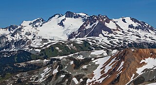
Overlord Mountain is a 2,625-metre (8,612-foot) glacier-clad peak located in the Garibaldi Ranges of the Coast Mountains, in Garibaldi Provincial Park of southwestern British Columbia, Canada. It is the highest point of the Fitzsimmons Range, which is a subset of the Garibaldi Ranges, and can be readily seen from the Whistler Blackcomb ski area. It is situated 15 km (9 mi) southeast of Whistler, and its nearest higher peak is Mount Macbeth, 3 km (2 mi) to the north-northeast. The Benvolio Glacier rests below the south aspect of the summit, the Fitzsimmons Glacier on the east aspect, and the expansive Overlord Glacier spans the northern and western aspects of the mountain. Precipitation runoff from the peak and meltwater from its glaciers drains into tributaries of the Cheakamus River. The first ascent of the mountain was made in 1923 by Phyllis Munday and Don Munday via the Benvolio Glacier. The mountain's descriptive name was recommended by the Garibaldi Park Board and officially adopted on September 2, 1930, by the Geographical Names Board of Canada.

Pelion Mountain is a 2,312-metre (7,585-foot) summit located in the Tantalus Range, in Tantalus Provincial Park, in southwestern British Columbia, Canada. It is situated 21 km (13 mi) northwest of Squamish, 0.8 km (0 mi) east of Ossa Mountain, and 5.5 km (3 mi) north-northwest of Mount Tantalus, which is its nearest higher peak and the highest peak in the Tantalus Range. Unnamed glaciers surround the peak and precipitation runoff from the peak drains into tributaries of the Squamish River and Clowhom River. The first ascent of the mountain was made in 1944 by V. Brink and B. McLellan. The mountain names in the Tantalus Range have a Greek mythology theme, and Pelion Mountain was named for the legendary Pelion mountain in Thessaly, upon which the Aloadaes are said to have attempted to pile Mount Pelion on top of Mount Ossa in their attempt to scale Olympus, home of the Greek gods. The mountain's name was officially adopted on June 6, 1957, by the Geographical Names Board of Canada.

Mount Rohr is a 2,423-metre (7,949-foot) mountain summit located in the Cayoosh Range of the Lillooet Ranges, in southwestern British Columbia, Canada. It is situated 29 km (18 mi) east of Pemberton, 8.2 km (5 mi) east of Cayoosh Mountain, and 6.8 km (4 mi) northeast of Joffre Peak, its nearest higher peak. Highway 99 traverses the southern base of the mountain between Cayoosh Pass and the west end of Duffy Lake, while Mount Chief Pascall rises on the opposite (south) side of this highway. Mount Rohr forms the westernmost boundary of Duffey Lake Provincial Park as it also represents the park's highest point. The mountain's name was submitted by Rev. Damasus Payne, a mountaineer, to honor Rev. Victor Sebastian Rohr (1873-1965), who spent 40 years in British Columbia and was a missionary to the First Nations in the region between Skookumchuck and Williams Lake. The name was officially adopted on April 21, 1966, by the Geographical Names Board of Canada. Two established climbing routes are the West Ridge and via Rohr Lake, both of which can be skied in winter. Precipitation runoff from the peak drains north into headwaters of Haylmore Creek, or south into Cayoosh Creek.

Mount Jimmy Jimmy is a 2,208-metre (7,244 ft) glaciated mountain located in the Coast Mountains in southwestern British Columbia, Canada. It is situated 32 kilometres (20 mi) northwest of Squamish, and 10 km (6 mi) northwest of Ossa Mountain, which is its nearest higher peak. Mt. Jimmy Jimmy is the highest point of the Tzoonie-Clowhom Divide. Precipitation runoff from the peak and meltwater from its immense glaciers drains into tributaries of the Squamish River and Clowhom River. The mountain was named for Chief Jimmy Jimmy, a leader of the Squamish Nation, who had traplines in the vicinity of the mountain and was a skilled paddler. The mountain's name was officially adopted on June 6, 1957, by the Geographical Names Board of Canada.
Cheakamus Mountain is a 2,588-metre (8,491-foot) glacier-clad peak located in the Garibaldi Ranges of the Coast Mountains, in Garibaldi Provincial Park of southwestern British Columbia, Canada. It is the fourth-highest peak of the Fitzsimmons Range, which is a subset of the Garibaldi Ranges. It is situated 16 km (10 mi) southeast of Whistler, and its nearest higher peak is Mount Benvolio, 1.65 km (1 mi) to the northwest. The Diavolo Glacier spreads out below the north aspect of the peak, and precipitation runoff from the peak with meltwater from the glacier drains into tributaries of the Cheakamus River. The peak was named in association with the river, which in turn is anglicized from Tseearkamisht, a Squamish word meaning "people who use the cedar rope fishing net". The mountain's name was officially adopted on September 2, 1930, by the Geographical Names Board of Canada. The first ascent of the mountain was made in 1950 by Roy Hooley, Jimmy Kilborn, and Ian Kirk.
Lydia Mountain is a 2,100-metre (6,890-foot) summit located in the Tantalus Range, in Tantalus Provincial Park, in southwestern British Columbia, Canada. It is situated 14.5 km (9 mi) northwest of Squamish, and 5.46 km (3 mi) south-southeast of Mount Tantalus, which is the highest peak in the Tantalus Range. The nearest higher neighbor is The Red Tusk, 0.5 km (0 mi) to the west, and Mount Niobe lies 2.17 km (1 mi) to the east-southeast. Lake Lovely Water lies below the eastern slope of the peak and precipitation runoff from the peak drains east to the Squamish River, and west to the Clowhom River via Red Tusk Creek. Topographic relief is significant as Lydia Mountain rises 1,400 meters (4,600 feet) above Red Tusk Creek in approximately three kilometers (two miles). The mountain's name was officially adopted on June 6, 1957, by the Geographical Names Board of Canada. The mountain was named for mythic Lydia, of which Tantalus was a primordial ruler in Greek mythology. Several peaks in the Tantalus Range are named in association with Tantalus. The first ascent of Lydia Mountain was made in 1914 by Basil Darling and Allan Morkill.
Mount Habrich is a mountain summit located in British Columbia, Canada.

Cloudburst Mountain is a summit in British Columbia, Canada.
Mount Tinniswood is a 2,606-metre (8,550-foot) mountain summit located in British Columbia, Canada.

Stupendous Mountain is a 2,682-metre (8,799-foot) mountain summit located in British Columbia, Canada.

Phyllis's Engine is a 2,517-metre (8,258-foot) granite pinnacle located in British Columbia, Canada.