Related Research Articles

Erosion is the action of surface processes that removes soil, rock, or dissolved material from one location on the Earth's crust and then transports it to another location where it is deposited. Erosion is distinct from weathering which involves no movement. Removal of rock or soil as clastic sediment is referred to as physical or mechanical erosion; this contrasts with chemical erosion, where soil or rock material is removed from an area by dissolution. Eroded sediment or solutes may be transported just a few millimetres, or for thousands of kilometres.
Soil, also commonly referred to as earth, is a mixture of organic matter, minerals, gases, liquids, and organisms that together support life of plants and soil organisms. Some scientific definitions distinguish dirt from soil by restricting the former term specifically to displaced soil.

Geomorphology is the scientific study of the origin and evolution of topographic and bathymetric features created by physical, chemical or biological processes operating at or near Earth's surface. Geomorphologists seek to understand why landscapes look the way they do, to understand landform and terrain history and dynamics and to predict changes through a combination of field observations, physical experiments and numerical modeling. Geomorphologists work within disciplines such as physical geography, geology, geodesy, engineering geology, archaeology, climatology, and geotechnical engineering. This broad base of interests contributes to many research styles and interests within the field.
Soil formation, also known as pedogenesis, is the process of soil genesis as regulated by the effects of place, environment, and history. Biogeochemical processes act to both create and destroy order (anisotropy) within soils. These alterations lead to the development of layers, termed soil horizons, distinguished by differences in color, structure, texture, and chemistry. These features occur in patterns of soil type distribution, forming in response to differences in soil forming factors.

A slump is a form of mass wasting that occurs when a coherent mass of loosely consolidated materials or a rock layer moves a short distance down a slope. Movement is characterized by sliding along a concave-upward or planar surface. Causes of slumping include earthquake shocks, thorough wetting, freezing and thawing, undercutting, and loading of a slope.
In geotechnical engineering, soil structure describes the arrangement of the solid parts of the soil and of the pore space located between them. It is determined by how individual soil granules clump, bind together, and aggregate, resulting in the arrangement of soil pores between them. Soil has a major influence on water and air movement, biological activity, root growth and seedling emergence. There are several different types of soil structure. It is inherently a dynamic and complex system that is affected by different factors.
Engineering geology is the application of geology to engineering study for the purpose of assuring that the geological factors regarding the location, design, construction, operation and maintenance of engineering works are recognized and accounted for. Engineering geologists provide geological and geotechnical recommendations, analysis, and design associated with human development and various types of structures. The realm of the engineering geologist is essentially in the area of earth-structure interactions, or investigation of how the earth or earth processes impact human made structures and human activities.
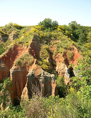
Denudation is the geological processes in which moving water, ice, wind, and waves erode the Earth's surface, leading to a reduction in elevation and in relief of landforms and landscapes. Although the terms erosion and denudation are used interchangeably, erosion is the transport of soil and rocks from one location to another, and denudation is the sum of processes, including erosion, that result in the lowering of Earth's surface. Endogenous processes such as volcanoes, earthquakes, and tectonic uplift can expose continental crust to the exogenous processes of weathering, erosion, and mass wasting. The effects of denudation have been recorded for millennia but the mechanics behind it have been debated for the past 200 years and have only begun to be understood in the past few decades.
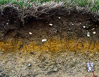
A soil horizon is a layer parallel to the soil surface whose physical, chemical and biological characteristics differ from the layers above and beneath. Horizons are defined in many cases by obvious physical features, mainly colour and texture. These may be described both in absolute terms and in terms relative to the surrounding material, i.e. 'coarser' or 'sandier' than the horizons above and below.
In the geosciences, paleosol is an ancient soil that formed in the past. The precise definition of the term in geology and paleontology is slightly different from its use in soil science.
Gypcrete or gypcrust is a hardened layer of soil, consisting of around 95% gypsum. Gypcrust is an arid zone duricrust. It can also occur in a semiarid climate in a basin with internal drainage, and is initially developed in a playa as an evaporate. Gypcrete is the arid climate's equivalent to calcrete, which is a duricrust that is unable to generate in very arid climates.
Claypan is a dense, compact, slowly permeable layer in the subsoil. It has a much higher clay content than the overlying material, from which it is separated by a sharply defined boundary. The dense structure restricts root growth and water infiltration. Therefore, a perched water table might form on top of the claypan. In the Canadian classification system, claypan is defined as a clay-enriched illuvial B (Bt) horizon.

A desert pavement, also called reg, serir, gibber, or saï is a desert surface covered with closely packed, interlocking angular or rounded rock fragments of pebble and cobble size. They typically top alluvial fans. Desert varnish collects on the exposed surface rocks over time.
Soil chemistry is the study of the chemical characteristics of soil. Soil chemistry is affected by mineral composition, organic matter and environmental factors. In the early 1870s a consulting chemist to the Royal Agricultural Society in England, named J. Thomas Way, performed many experiments on how soils exchange ions, and is considered the father of soil chemistry. Other scientists who contributed to this branch of ecology include Edmund Ruffin, and Linus Pauling.
The Canadian System of Soil Classification is more closely related to the American system than any other, but they differ in several ways. The Canadian system is designed to cover only Canadian soils. The Canadian system dispenses with the sub-order hierarchical level. Solonetzic and Gleysolic soils are differentiated at the order level.
A fragipan is a diagnostic horizon in USDA soil taxonomy. They are altered subsurface soil layers that restrict water flow and root penetration. Fragipans are similar to a duripan in how they affect land-use limitations. In soil descriptions, they are commonly denoted by a Bx or Btx symbol. They often form in loess ground. The first record of fragipans is probably that by John Hardcastle in New Zealand in the 1880s.

Bank erosion is the wearing away of the banks of a stream or river. This is distinguished from erosion of the bed of the watercourse, which is referred to as scour.
The soil biomantle can be described and defined in several ways. Most simply, the soil biomantle is the organic-rich bioturbated upper part of the soil, including the topsoil where most biota live, reproduce, die, and become assimilated. The biomantle is thus the upper zone of soil that is predominantly a product of organic activity and the area where bioturbation is a dominant process.

Soil aggregate stability is a measure of the ability of soil aggregates—soil particles that bind together—to resist breaking apart when exposed to external forces such as water erosion and wind erosion, shrinking and swelling processes, and tillage. Soil aggregate stability is a measure of soil structure and can be affected by soil management.
References
- ↑ Bell, F.G. (2007). Engineering geology (2nd ed.). Oxford: Butterworth-Heinemann. p. 84. ISBN 9780080469522.
- ↑ Glanville, S. F.; Smith, G. D. (1988). "Aggregate breakdown in clay soils under simulated rain and effects on infiltration". Soil Research. 26 (1): 111–120. doi:10.1071/sr9880111. ISSN 1838-6768.
| | This erosion article is a stub. You can help Wikipedia by expanding it. |