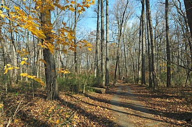
Rock Creek Park is a large urban park that bisects the Northwest quadrant of Washington, D.C. Created by Act of Congress in 1890, the park comprises 1,754 acres, generally along Rock Creek, a tributary of the Potomac River.

Chillum is an unincorporated area and census-designated place in Prince George's County, Maryland, United States, bordering Washington, D.C., and Montgomery County.

Sligo Creek is a free-flowing tributary of the Northwest Branch of the Anacostia River in Maryland. The creek is approximately 9.1 miles (14.6 km) long, with a drainage area of about 11.6 square miles (30 km2).

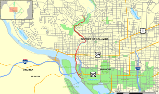
The Rock Creek and Potomac Parkway, informally called the Rock Creek Parkway, is a parkway maintained by the National Park Service as part of Rock Creek Park in Washington, D.C. It runs next to the Potomac River and Rock Creek in a generally north–south direction, carrying four lanes of traffic from the Lincoln Memorial and Arlington Memorial Bridge north to a junction with Beach Drive near Connecticut Avenue at Calvert Street, N.W., just south of the National Zoological Park.

Maryland Route 190 is a state highway in the U.S. state of Maryland. Known as River Road, the highway runs 15.88 miles (25.56 km) from MD 112 near Seneca east to Western Avenue at the District of Columbia boundary in Bethesda. MD 190 parallels the Potomac River through the affluent southwestern Montgomery County communities of Potomac and Bethesda and connects those suburbs with Interstate 495 (I-495). River Road was paved from Washington, D.C. west through part of Bethesda in the early 1910s. A second section of MD 190 was constructed through Potomac in the mid-1920s. The Bethesda and Potomac portions of the route were unified in the late 1920s. MD 190 was extended west toward Seneca in two steps in 1950 and the early 1970s. The highway was expanded to a four-lane divided highway through Bethesda in the early 1960s.

Maryland Route 195 is a state highway in the U.S. state of Maryland. Known as Carroll Avenue, the state highway runs 1.90 miles (3.06 km) from Eastern Avenue at the District of Columbia boundary in Takoma Park north to MD 193 in Silver Spring. MD 195 is the main north–south state highway through Takoma Park in southeastern Montgomery County. The highway provides access to Washington Adventist University and Washington Adventist Hospital and crosses Sligo Creek on the Carroll Avenue Bridge. The state highway was constructed from Washington, D.C. to Silver Spring in the late 1920s on a road that has existed since the 19th century. The Carroll Avenue Bridge was built in 1932 as the third bridge at the site. Reconstruction of the bridge began in 2015 and was completed in 2017.

Maryland Route 650 is a state highway in the U.S. state of Maryland. Known as New Hampshire Avenue for most of its length, the state highway runs 25.89 mi (41.67 km) from Eastern Avenue at the Washington, D.C. border north to MD 108 in Etchison. MD 650 serves as a major north-south commuter route in northwestern Prince George's County and eastern Montgomery County, connecting the District of Columbia with the residential suburbs of Takoma Park, Langley Park, Adelphi, Hillandale, White Oak, and Colesville. By contrast, the part of MD 650 north of Spencerville is a quiet rural road connecting several small communities along the northeastern fringe of Montgomery County.

Maryland Route 410 (MD 410) is a state highway in the U.S. state of Maryland and known for most of its length as East–West Highway. The highway runs east to west for 13.92 miles (22.40 km) from MD 355 in Bethesda east to Pennsy Drive in Landover Hills. MD 410 serves as a major east–west commuter route through the inner northern suburbs of Washington, D.C., connecting the commercial districts of Bethesda, Silver Spring, and Hyattsville. In addition, the highway serves the industrial area of Landover Hills and the residential suburbs of Chevy Chase, Takoma Park, Chillum, Riverdale, and East Riverdale. The road also connects many of the arterial highways and freeways that head out of Washington. Additionally, it provides a highway connection to transit and commercial hubs centered around Washington Metro subway stations in Bethesda, Takoma Park, Hyattsville, Silver Spring, and New Carrollton–the latter two of which provide additional connections to MARC and Amtrak trains.
Carole Highlands is an unincorporated community in Prince George's County, Maryland, United States. It is contained between East West Highway to the south, University Boulevard to the north, Larch Avenue, Hopewell Avenue, and 15th Avenue to the west, and Riggs Road to the east. Carole Highlands borders the adjacent neighborhoods of Chillum, Green Meadows, Lewisdale, and Langley Park in Prince George's County, while bordering the city of Takoma Park in Montgomery County. For statistical purposes, it is part of the Langley Park census-designated place (CDP). The community also has a community association and non-profit: Carole Highlands Neighborhood Association

U.S. Route 29 is a north–south United States highway that runs for 1,036 miles (1,667 km) from the western suburbs of Baltimore, Maryland, to Pensacola, Florida. In the U.S. state of Maryland, US 29 is a major highway that emerges from Washington, D.C., and runs north into eastern Montgomery County, stretching over 25.859 miles (41.62 km) through the state and terminating at Maryland Route 99 outside of Ellicott City. It serves the cities of Columbia and Ellicott City and provides the westernmost north–south route between Washington, D.C., and Baltimore.

Randolph Road is a county highway in the U.S. state of Maryland. The highway is the major component of a mostly four- to six-lane 16.8-mile (27.0 km) highway spanning southern Montgomery County and northwestern Prince George's County that also includes Montrose Road, Josiah Henson Memorial Parkway, and Cherry Hill Road, and forms an important link between eastern Montgomery County and Rockville. Montrose Road begins at Maryland Route 189 in Potomac. The highway heads east through a junction with Interstate 270 (I-270) before the main course continues as Josiah Henson Memorial Parkway in North Bethesda. Josiah Henson Memorial Parkway continues through a junction with MD 355, east of which the highway becomes Randolph Road. Randolph Road intersects MD 586 and MD 185 in Wheaton, MD 97 in Glenmont, and MD 650 in Colesville. The highway continues southeast toward Fairland, where it meets U.S. Route 29. The highway continues from US 29 as Cherry Hill Road through an intersection with MD 212 in Calverton before reaching its eastern end at US 1 in College Park.

Northwest Branch Anacostia River is a 21.5-mile-long (34.6 km) free-flowing stream in Montgomery County and Prince George's County, Maryland. It is a tributary of the Anacostia River, which flows to the Potomac River and the Chesapeake Bay.

The Anacostia Tributary Trail System (ATTS) is a unified and signed system of stream valley trails joining trails along the Anacostia tributaries of Northwest Branch, Northeast Branch, Indian Creek and Paint Branch with a trail along the Anacostia River, set aside and maintained by the Maryland-National Capital Park and Planning Commission (M-NCPPC) in the Maryland suburbs of Washington, D.C.

Maryland Route 192 is a state highway in the U.S. state of Maryland. The highway runs 2.53 miles (4.07 km) from Summit Avenue in Kensington east to MD 97 in Forest Glen. MD 192 connects MD 185 with the Kensington station on MARC's Brunswick Line and MD 97 and Interstate 495 (I-495) with the Forest Glen station on the Washington Metro's Red Line. The highway was constructed from Forest Glen to Kensington in the mid-1920s. MD 192 also included three sections between MD 97 and U.S. Route 29 in Four Corners built in the mid-1930s. The final segment east of MD 97 was removed from the state highway system in the late 1980s.

Maryland Route 320 is a state highway in the U.S. state of Maryland. Known as Piney Branch Road, the highway runs 2.84 miles (4.57 km) from Eastern Avenue at the District of Columbia boundary in Takoma Park north to MD 650 in Adelphi. MD 320 is a southwest–northeast highway that connects Takoma Park and Silver Spring in southeastern Montgomery County with Adelphi in far western Prince George's County. The state highway originally extended from downtown Silver Spring to White Oak and connected with U.S. Route 29 at both ends. The Silver Spring–Adelphi portion of the highway was constructed in 1910. The segment through Takoma Park and the Adelphi–White Oak segment, which later became MD 650, were built in the early 1930s; the Takoma Park portion was built as MD 513. MD 320 was widened over its whole length in the late 1940s and reduced to its present course in the mid-1950s.

Sligo Creek Parkway is a two-lane at-grade automobile parkway in Montgomery County in the U.S. state of Maryland. The two-lane parkway runs 5.6 mi (9.0 km) from Maryland Route 650 in Takoma Park through Silver Spring north to MD 193 in Maryland. Sligo Creek Parkway parallels Sligo Creek and the Sligo Creek Trail as it passes through various units of Sligo Creek Park and by a variety of recreational facilities. The parkway is maintained by the Maryland-National Capital Park and Planning Commission. Sligo Creek Parkway is closed to trucks at all times. In addition, the section between Old Carroll Avenue and MD 320 is closed to automobile traffic on Sundays.

Four Corners is a neighborhood and census-designated place (CDP) in Montgomery County, Maryland, United States. Many residents consider the neighborhood a part of Silver Spring, to whose CDP it belonged until 2010. It had a population of 8,316 at the 2020 census.

The Rock Creek Trails are a series of trails through the Rock Creek valley and along the Potomac River in Washington, DC and Montgomery County, MD. The main route extends 22 miles from Lake Needwood in Maryland to the Inlet Bridge in Washington, DC, with a loop in the north part of Rock Creek Park and other trails through the Klingle Valley, Turkey Branch Valley and along the North Branch of Rock Creek. There are three separate trails that make up the main Rock Creek Trail route and others that connect to it. Along the Potomac River from Arlington Memorial Bridge to Rock Creek is a section sometimes called the Shoreline Trail.

Franklin Knolls is a residential neighborhood located in Silver Spring, a census-designated place in Montgomery County.


