Slim, Oklahoma

Last updated
USA Oklahoma location map.svg
Red pog.svg
Slim
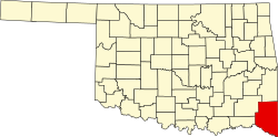
Location of Slim within the state of Oklahoma.

Slim was an unincorporated community in southwestern McCurtain County, Oklahoma, United States. [1] The community is located six miles north of Valliant. The community is about one-half mile south of Pine Creek Lake and the community of Mound Grove is one mile east. [2]

A post office operated in Slim from January 15, 1916 to July 31, 1933. During the years following Oklahoma's statehood, Slim's residents were economically more closely connected to communities in Pushmataha County, as the community lay near the Pushmataha County line. [3]

Related Research Articles

Cloudy is an unincorporated community located in Pushmataha County, Oklahoma, United States. It is 12 miles northeast of Rattan. Cloudy is located at 34°18′07″N95°16′52″W.

Adel is an unincorporated community in northwestern Pushmataha County, Oklahoma, United States, 12 miles west of Clayton. Adel is located at 34°34′45″N95°35′40″W.

Belzoni is a community in Pushmataha County, Oklahoma, United States. Located several miles southwest of Rattan, it was formerly home to a thriving community and continues as a place name.

Corinne is an unincorporated community in southern Pushmataha County, Oklahoma, United States, located 19 miles east of Antlers. Using the Public Land Survey System commonly in use in Oklahoma, the community is located in T22-4S-R19E.

Darwin is an unincorporated community in western Pushmataha County, Oklahoma, United States, nine miles west of Antlers. It is approximately one-half mile east of the Atoka County border.

Dela is an unincorporated community in Pushmataha County, Oklahoma, United States, located six miles southeast of Antlers. It is within the jurisdiction of the Choctaw Nation of Oklahoma.

Dunbar is a community in Pushmataha County, Oklahoma, United States, 17 miles north of Antlers. Dunbar is located at 34°27′31″N95°33′38″W.

Ethel is an unincorporated community in Pushmataha County, Oklahoma, United States, six miles east of Antlers. Ethel is located at 34°13′46″N95°32′39″W.

Eubanks is a former community in Pushmataha County, Oklahoma, United States, 13 miles north of Antlers.

Finley is an unincorporated community in Pushmataha County, Oklahoma, 10 miles northeast of Antlers.

Kiamichi is a former community in northern Pushmataha County, Oklahoma, United States, six miles east of Tuskahoma.

Miller is an unincorporated community in southwestern Pushmataha County, Oklahoma, United States, 10 miles northwest of Antlers and a short distance west of Moyers.

Nolia is a former community in eastern Pushmataha County, Oklahoma, United States, five miles east of Nashoba. Nolia is located at 34°28′35″N95°09′06″W.

Oleta is an unincorporated community in southeastern Pushmataha County, Oklahoma, United States, 15 miles east of Antlers. According to the Public Land Survey System in use in Oklahoma it is located in S18-T4S-R19E.

Rodney, Oklahoma

Rodney is a former community in Pushmataha County, Oklahoma, United States, five miles north of Antlers.

Sardis was a community in northern Pushmataha County, Oklahoma, United States, six miles northwest of Clayton.

Snow is an unincorporated community in Pushmataha County, Oklahoma, United States, 18 miles northeast of Antlers. Snow is located at 34°23′45″N95°24′46″W.

Sobol is an unincorporated community in southeastern Pushmataha County, Oklahoma, United States.

Stanley, Oklahoma

Stanley is an unincorporated community in northern Pushmataha County, Oklahoma, United States, eight miles southwest of Clayton.

Ringold, Oklahoma

Ringold is an unincorporated community in western McCurtain County, Oklahoma, United States, 12 miles northwest of Wright City. It was formerly called Burwell.

References

  1. U.S. Geological Survey Geographic Names Information System: Slim, Oklahoma
  2. Wright City, Oklahoma, 7.5 Minute Topographic Quadrangle, USGS, 1963 (1992 rev)
  3. George B. Shirk, Oklahoma Place Names, p. 194.

Coordinates: 34°05′03″N95°06′16″W / 34.08417°N 95.10444°W / 34.08417; -95.10444